
Alexandra Canal (New South Wales) facts for kids
Quick facts for kids Alexandra Canal |
|
|---|---|

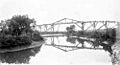
Alexandra Canal, looking upstream towards the Sydney CBD
|
|

Location of the mouth in Greater Sydney
|
|
| Other name(s) | Shea's Creek |
| Country | Australia |
| State | New South Wales |
| Local government areas |
|
| Physical characteristics | |
| Main source | Sydney Park Alexandria 1.5 metres (4 ft 11 in) AHD 33°54′37″S 151°11′29″E / 33.91028°S 151.19139°E |
| River mouth | Cooks River Tempe 0.5 metres (1 ft 8 in) AHD 33°55′59″S 151°9′43″E / 33.93306°S 151.16194°E |
| Length | 4.5 kilometres (2.8 mi) |
| Width |
|
| Basin features | |
| River system | Cooks River |
| Bridges |
|
| Type: | Built |
| Criteria: | a., c., d., e., f., g. |
| Designated: | 15 November 2002 |
| Reference #: | 01621 |
The Alexandra Canal is a special waterway in southern Sydney, New South Wales, Australia. It's not a natural river but an artificial waterway, meaning it was built by people. It's a branch of the Cooks River and is listed as a heritage site because of its history. The canal was named after Princess Alexandra, who married a future king of England in 1863.
This canal was Sydney's first man-made waterway for ships. It stretches about 4 kilometers from Alexandria, flowing through St Peters and Mascot, past Sydney Airport, and into the Cooks River at Tempe. The Cooks River then flows into Botany Bay. The canal is usually about 60 meters wide, widening to 80 meters at its end. It is one of only two canals built in New South Wales that ships can use.
Contents
How the Canal Was Built
The area where Alexandra Canal now sits was once a salt marsh called Shea's Creek. This creek was a branch of the Cooks River. Factories and businesses in the early days used Shea's Creek for their drainage. People often complained about the pollution.
To fix this, work began in 1887 to turn Shea's Creek into a canal. The idea was to help factories and industries in the area. They wanted to make it easier to transport goods by ship. People hoped the canal would turn the area into a big industrial hub, like "Birmingham of Australia." Many unemployed workers helped build the canal during a tough economic time in the 1890s.
The canal was originally lined with special barriers made of wood and earth. The first part of the canal went from near the railway bridge to the Canal Road Bridge. Later, there were plans to make it even longer, but only part of that extension was built.
Discoveries During Construction
In 1896, during the digging of Shea's Creek, something amazing was found. Workers discovered the bones of a dugong (a sea mammal, like a manatee) in the clay. Experts from the Australian Museum studied the bones. They found marks showing the animal had been cut up with a blunt tool. Two stone hatchet heads were also found nearby. These discoveries tell us that Indigenous Australians lived and hunted in this area long before Europeans arrived.
As parts of the canal were finished, docks were built along its sides. This was to encourage businesses to use the canal for shipping.
Challenges and Changes
The main part of the canal was finished around 1900. However, it never became as successful as planned. Ships found it hard to use because the water was often too shallow. The canal also kept filling up with mud.
Later, in the 1930s, road transport became more popular. This meant fewer people needed to use the canal for shipping. Two bridges over the canal that used to lift up for ships were changed to stay fixed. By the early 1940s, almost no one used the canal for navigation. The docks were no longer kept up and were eventually taken down.
During World War II, many large sheds were built along the eastern side of the canal. These were used to store huge amounts of wool during the war. Some of these old sheds are still there today.
Pollution and Cleanup Efforts
For many years, the canal became very polluted. Waste from nearby industries flowed into it, and the mud at the bottom was full of harmful metals. In 1998, Sydney Water planned a big project to clean up the canal. They wanted to improve the water quality, but this plan was later stopped.
Today, five smaller streams flow into the canal. In 1999, a very important internet cable, the Southern Cross Cable, was laid under the canal. This cable carries a lot of Australia's internet traffic to North America.
Future Plans for the Canal
In 1998, there was an idea to turn Alexandra Canal into a beautiful green area. Students from the University of New South Wales were asked to design ways to make it a "stunning water and green recreation corridor." They received money to help them create their designs. Nine of their ideas were shown to the public.
By 1999, a bigger plan was announced. This plan included building homes for many people, along with cafes, restaurants, and places for boating on the canal. A detailed plan in 2001 showed bike paths along both sides of the canal. In 2003, work was set to begin on these paths. Officials said the paths would bring people to the canal for picnics, walking, and cycling.
However, in 2003, the Department of Environment and Climate Change said it was too risky to disturb the canal. This was likely due to the pollution in the sediment. Because of this, the plans for redevelopment were put on hold.
What the Canal Looks Like Today
Alexandra Canal is an artificial waterway that is about 4.5 kilometers long. It stretches from the Cooks River in the south to near Huntley Street in Alexandria in the north. Its banks are made of sloped sandstone blocks, which give it a unique look.
The canal is crossed by four bridges:
- Shell pipeline bridge
- Sydenham to Botany railway line bridge
- Canal Road Bridge
- A small footbridge
The northern end of the canal connects to the Sheas Creek Stormwater Channel. On the eastern side, north of Coward Street, you can see old wool storage buildings from the mid-1900s. Some of these buildings are now used for different things, while others are empty. They are recognized as heritage buildings.
The southern part of the canal, near the Cooks River, was changed when the airport expanded. Some of the original stone banks in this area were removed. However, most of the canal's original stone work is still in place.
Why Alexandra Canal is Important
Alexandra Canal is very important for its history, beauty, and scientific value.
Historical Importance
It is a rare example of a canal built for navigation in Australia during the 1800s. It's one of only two such canals in New South Wales. It shows how the government tried to create water transport to help industries grow in the Alexandria and Botany areas. It also shows how the government used unemployed workers to build big projects during tough economic times.
The canal played a big part in how the local area and nearby suburbs changed. It helped fill in large areas of low-lying land so they could be developed for factories and businesses.
Aesthetic Importance
The parts of the canal that still have their original stone banks look very nice. The dry-packed sandstone gives the canal a textured and colored finish. It's a major landmark and a striking part of the industrial landscape, especially when seen from the Ricketty Street Bridge and Airport Drive.
Scientific Importance
The discovery of butchered dugong bones, Aboriginal axes, and an ancient forest during the canal's excavation was very important. These findings helped scientists understand how sea levels have changed along Australia's eastern coast. They also provided evidence of how long Aboriginal people have lived in the area. The original stone construction of the canal is also a rare example of late 19th-century engineering.
Alexandra Canal was officially listed on the New South Wales State Heritage Register on November 15, 2002.
Images for kids
-
Pipeline over Shea's Creek, 1886.
Image:Macleay Museum -
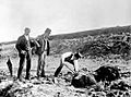
Excavation of dugong remains at Shea's Creek in 1896, during construction of the Alexandra Canal. The curator of the Australian Museum, Robert Etheridge, stands centre wearing a top hat.
Image: Australian Museum archives


