Allan, Queensland facts for kids
Quick facts for kids AllanQueensland |
|||||||||||||||
|---|---|---|---|---|---|---|---|---|---|---|---|---|---|---|---|

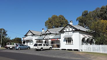
Darling Downs Hotel erected 1920s
|
|||||||||||||||
| Population | 91 (2021 census) | ||||||||||||||
| • Density | 10.46/km2 (27.1/sq mi) | ||||||||||||||
| Postcode(s) | 4370 | ||||||||||||||
| Area | 8.7 km2 (3.4 sq mi) | ||||||||||||||
| Time zone | AEST (UTC+10:00) | ||||||||||||||
| Location | |||||||||||||||
| LGA(s) | Southern Downs Region | ||||||||||||||
| State electorate(s) | Southern Downs | ||||||||||||||
| Federal Division(s) | Maranoa | ||||||||||||||
|
|||||||||||||||
Allan is a small country area in Queensland, Australia. It is part of the Southern Downs Region. This place used to be called Sandy Creek. In 2021, about 91 people lived in Allan.
Contents
What is Allan Like?
Land and Water
The Condamine River forms the north-eastern edge of Allan. Sandy Creek flows through the area. It starts near Leslie Dam in the west. Then it flows towards Leslie in the north-west. Eventually, Sandy Creek joins the Condamine River.
Roads and Railways
The Cunningham Highway goes through Allan. It connects Rosenthal Heights in the south-east to Leslie Dam in the west. The South Western railway line runs close to the highway. However, there is no train station in Allan itself.
Important local roads include Sandy Creek Road. It goes from the highway north-west to Leslie. Leslie Dam Road goes south from the highway towards the Leslie Dam.
Farming in Allan
Most of the land in Allan is used for farming. Farmers grow crops and raise animals like cattle.
A Look Back in Time
How Allan Got Its Name
Allan was probably named after William Allan. He was an early settler in the area. This name was given when the railway station opened in 1904. Another idea is that it was named after Allan Cunningham. He was a famous botanist and explorer. The area was first known as Sandy Creek, named after the local creek.
Old Buildings and Hotels
Several hotels were built in Sandy Creek in 1866. The Darling Downs Hotel, also called the Sandy Creek Pub, was built in 1875 by Adam Smith. It was a stop for coaches to change horses from 1880. This continued until the railway opened in 1904. The current Darling Downs Hotel building was built in the 1920s.
Schools and Churches
Sandy Creek Provisional School opened on May 13, 1872. W. Wallace and H. Marshall built the school and a house for £304/10/0. In 1929, its name changed to Allan State School. The school closed in December 1967.
St Matthew's Anglican Church opened on November 17, 1901. It closed in 1969. The church building was moved to the Slade School in Warwick.
The Railway Station
The South Western railway line opened from Warwick to Thane on July 1, 1904. Allan railway station served the local area. As of December 2019, Allan railway station is no longer in use.
Who Lives in Allan?
In 2016, Allan had 87 people living there. By 2021, the population grew slightly to 91 people.
Special Places in Allan
Allan has some places that are important to its history:
- Allan State School (former), located at 280 Sandy Creek Road. It used to be called Sandy Creek School.
- Darling Downs Hotel (Sandy Creek Pub), found at 345 Sandy Creek Road.
Learning Opportunities
There are no schools directly in Allan. For primary school, students can go to Wheatvale State School in Wheatvale (north-west). Or they can attend Warwick West State School in Warwick (south-east). For high school, the closest option is Warwick State High School in Warwick (east).
Fun Things to Do
The Sandy Creek Raceway is a fun place in Allan. It is home to the Warwick Kart Club. You can find it at 335 Sandy Creek Road.
 | Frances Mary Albrier |
 | Whitney Young |
 | Muhammad Ali |


