Allandale, Queensland facts for kids
Quick facts for kids AllandaleQueensland |
|||||||||||||||
|---|---|---|---|---|---|---|---|---|---|---|---|---|---|---|---|

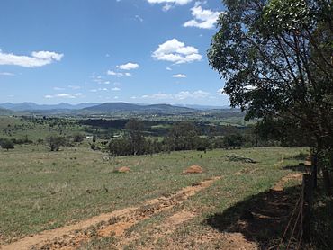
Paddocks and Mount French, 2016
|
|||||||||||||||
| Population | 69 (2021 census) | ||||||||||||||
| • Density | 1.414/km2 (3.66/sq mi) | ||||||||||||||
| Postcode(s) | 4310 | ||||||||||||||
| Area | 48.8 km2 (18.8 sq mi) | ||||||||||||||
| Time zone | AEST (UTC+10:00) | ||||||||||||||
| State electorate(s) | Scenic Rim | ||||||||||||||
| Federal Division(s) | Wright | ||||||||||||||
|
|||||||||||||||
Allandale is a small country area, also called a locality, in the Scenic Rim Region of Queensland, Australia. It's a quiet place with lots of open land. In 2021, only 69 people lived in Allandale.
Contents
What Allandale Looks Like
Allandale is a rural area, meaning it's mostly countryside. You won't find any big highways here.
Rivers and Land Use
The Teviot Brook river flows through the northern part of Allandale. Much of the land is used for farming. In the southeastern part, there are hills that are mostly undeveloped. This area is where water collects and flows into Allan Creek, which then joins the Logan River to the east.
A Look Back in Time
Allandale once had its own school!
Allandale State School
The Allandale State School first opened its doors on 27 February 1928. It taught local children for many years. However, the school closed down on 24 March 1963. It used to be located near the corner of Radcliffe/Geiger Road and Hutchinson Road.
Who Lives in Allandale?
The number of people living in Allandale is quite small.
Population Details
In 2016, there were 56 people living in Allandale. There were 33 homes in the area. Most of the people were males (60%), and females made up 40%. The average age of people living there was 53 years old.
By 2021, the population of Allandale grew a little bit to 69 people.
 | Janet Taylor Pickett |
 | Synthia Saint James |
 | Howardena Pindell |
 | Faith Ringgold |


