Alna, Maine facts for kids
Quick facts for kids
Alna, Maine
|
||
|---|---|---|
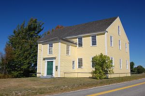
Alna Meeting House, built in 1789
|
||
|
||
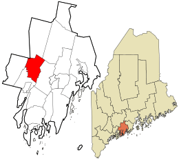
Location in Lincoln County and the state of Maine.
|
||
| Country | United States | |
| State | Maine | |
| County | Lincoln | |
| Settled | 1760 | |
| Incorporated | 1794 | |
| Government | ||
| • Type | Town Meeting | |
| Area | ||
| • Total | 21.32 sq mi (55.22 km2) | |
| • Land | 20.90 sq mi (54.13 km2) | |
| • Water | 0.42 sq mi (1.09 km2) | |
| Elevation | 128 ft (39 m) | |
| Population
(2020)
|
||
| • Total | 710 | |
| • Density | 34/sq mi (13.1/km2) | |
| Time zone | UTC-5 (Eastern) | |
| • Summer (DST) | UTC-4 (Eastern) | |
| ZIP code |
04535
|
|
| Area code(s) | 207 | |
| FIPS code | 23-01010 | |
| GNIS feature ID | 0582321 | |
| Website | http://alna.maine.gov | |
Alna is a small town in Lincoln County, Maine, United States. It's known for its old buildings and the historic village of Head Tide. In 2020, about 710 people lived in Alna. The town is also home to the Wiscasset, Waterville and Farmington Railway Museum, which is a popular place to visit.
Contents
History of Alna
Alna was first settled around 1760. It became an official town in 1794. At first, it was called New Milford. But the people living there didn't like that name. So, in 1811, the name was changed to Alna. This name comes from a Latin word for the alder tree. Many alder trees grow along the Sheepscot River in the area.
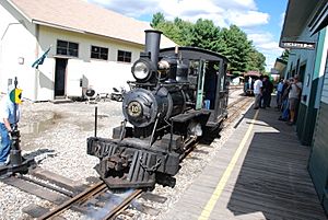
Alna was also the location of Maine's very first fish hatchery. This hatchery started soon after the Civil War. From 1895 to 1933, a special narrow-gauge railway called the Wiscasset, Waterville and Farmington Railway ran through the town. It had three stations: Head Tide, Alna Center, and Sheepscot. Today, the Sheepscot station is the main spot for a special heritage railway where you can ride old trains.
In 2024, a local shop called The Alna Store was named one of America's Best Restaurants by The New York Times. It's located at the intersection of Dock Road and Alna Road.
Geography of Alna
Alna covers about 21.32 square miles (55.22 square kilometers). Most of this area is land, about 20.90 square miles (54.13 square kilometers). The rest is water, about 0.42 square miles (1.09 square kilometers). The Sheepscot River flows through Alna.
Two main roads cross the town: Maine State Route 194 and Maine State Route 218. Alna shares its borders with several other towns:
- To the south: Wiscasset
- To the west: Dresden
- To the north: Pittston, Whitefield, and Jefferson
- To the east (across the Sheepscot River): Newcastle
Population of Alna
| Historical population | |||
|---|---|---|---|
| Census | Pop. | %± | |
| 1800 | 636 | — | |
| 1810 | 797 | 25.3% | |
| 1820 | 978 | 22.7% | |
| 1830 | 1,175 | 20.1% | |
| 1840 | 990 | −15.7% | |
| 1850 | 916 | −7.5% | |
| 1860 | 805 | −12.1% | |
| 1870 | 747 | −7.2% | |
| 1880 | 687 | −8.0% | |
| 1890 | 512 | −25.5% | |
| 1900 | 444 | −13.3% | |
| 1910 | 457 | 2.9% | |
| 1920 | 320 | −30.0% | |
| 1930 | 294 | −8.1% | |
| 1940 | 339 | 15.3% | |
| 1950 | 350 | 3.2% | |
| 1960 | 347 | −0.9% | |
| 1970 | 315 | −9.2% | |
| 1980 | 425 | 34.9% | |
| 1990 | 571 | 34.4% | |
| 2000 | 675 | 18.2% | |
| 2010 | 709 | 5.0% | |
| 2020 | 710 | 0.1% | |
| U.S. Decennial Census | |||
What the 2010 Census Showed
In 2010, there were 709 people living in Alna. Most of the people living in Alna were White. A small number of people were from other racial backgrounds. About 28% of the homes had children under 18 living there. The average age of people in Alna was about 45.7 years old.
Fun Places to Visit in Alna
Alna has some interesting historical sites and attractions:
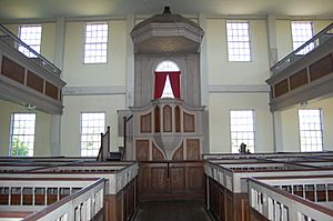
- Alna Meetinghouse (built in 1789)
- Alna School (built in 1795)
- Wiscasset, Waterville and Farmington Railway Museum
Famous People from Alna
Some notable people have connections to Alna:
- Fred H. Albee, a famous surgeon
- John T. Averill, a US congressman
- Edwin Arlington Robinson, a well-known poet
See also
 In Spanish: Alna (Maine) para niños
 | Anna J. Cooper |
 | Mary McLeod Bethune |
 | Lillie Mae Bradford |


