
Amblie facts for kids
Quick facts for kids
Amblie
|
|
|---|---|
|
Part of Ponts sur Seulles
|
|
 |
|

Amblie
Location in France

Amblie
Location in Normandy
|
|
| Country | France |
| Region | Normandy |
| Department | Calvados |
| Arrondissement | Caen |
| Canton | Thue et Mue |
| Commune | Ponts sur Seulles |
| Area
1
|
5.82 km2 (2.25 sq mi) |
| Population
(2018)
|
274 |
| • Density | 47.08/km2 (121.9/sq mi) |
| Time zone | UTC+01:00 (CET) |
| • Summer (DST) | UTC+02:00 (CEST) |
| Postal code |
14480
|
| Elevation | 2–53 m (6.6–173.9 ft) (avg. 25 m or 82 ft) |
| 1 French Land Register data, which excludes lakes, ponds, glaciers > 1 km2 (0.386 sq mi or 247 acres) and river estuaries. | |
Amblie (pronounced "ahm-blee") was once a small village in the Calvados area of Normandy, northwestern France. On January 1, 2017, Amblie joined with other villages to form a new, larger commune called Ponts sur Seulles.
Contents
Where is Amblie?

Amblie is located about 17 kilometers (10 miles) northwest of Caen. It's also 15 kilometers (9 miles) northeast of Bayeux. The village is very close, only 5 kilometers (3 miles), to the famous Normandy landings beaches from World War II.
Amblie sits between two river valleys: the Thue and the Seulles. These rivers flow through the area. The Seulles river forms the northern edge of the village. The Thue river flows from the south right through the village. These rivers make the land very good for farming.
You can reach Amblie by road D22 from Caen. Another road, D35, goes through the village itself. Besides the main village, there are small areas called Le Bout de Haut and Les Planches. Most of the land around Amblie is used for farming. There are only a few small patches of forest.
 |
Colombiers-sur-Seulles | Banville | Reviers | |
| Creully | Beny-sur-Mer | |||
| Lantheuil | Le Fresne-Camilly | Fontaine-Henry |
What's in a Name?
The name "Amblie" might come from the Latin words Ambo Amnes. This means "two rivers," which makes sense because Amblie is located between the Thue and Seulles rivers.
A Look Back in Time: Amblie's History
This small village has a long history. People have lived here since ancient times. For many centuries, important French noble families owned land in Amblie.
In the 1800s, the textile industry grew in Amblie. This means they made cloth and fabric. Many women worked in this industry. Water mills along the Thue river helped with this work. These mills also ground grain into flour. They kept working until 1945.
Like many small villages, Amblie's population started to shrink in the early 1900s. After World War I, some farmers from Belgium moved to the area.
Amblie was very close to the D-Day landing beaches during World War II. Luckily, the village itself was not destroyed. It even helped the nearby city of Caen. Amblie became a safe place for thousands of injured people from Caen.
A special event happened in Amblie on June 29, 1944. The Canadian Red Ensign flag was raised over the headquarters of the First Canadian Army. This was a big moment! It was the first time Canadian soldiers fought under their own flag. This flag had the British Union Jack in the corner. It also had the Canadian coat of arms. The Red Ensign was Canada's national flag until 1965. Then, it was replaced by the red and white maple leaf Flag of Canada we know today.
Who Lived Here?
The people who live in Amblie are called Ambliais (for boys and men) or Ambliaises (for girls and women). Sometimes they are also called Ambligeois or Ambligeoises.
The population of Amblie has changed a lot over the years.
| Historical population | ||||||||||||||||||||||||||||||||||||||||||||||||||||||||||||||||||||||||||||||||||||||||||||||||||||||||||||||||
|---|---|---|---|---|---|---|---|---|---|---|---|---|---|---|---|---|---|---|---|---|---|---|---|---|---|---|---|---|---|---|---|---|---|---|---|---|---|---|---|---|---|---|---|---|---|---|---|---|---|---|---|---|---|---|---|---|---|---|---|---|---|---|---|---|---|---|---|---|---|---|---|---|---|---|---|---|---|---|---|---|---|---|---|---|---|---|---|---|---|---|---|---|---|---|---|---|---|---|---|---|---|---|---|---|---|---|---|---|---|---|---|---|
|
|
|||||||||||||||||||||||||||||||||||||||||||||||||||||||||||||||||||||||||||||||||||||||||||||||||||||||||||||||
| Source: EHESS and INSEE | ||||||||||||||||||||||||||||||||||||||||||||||||||||||||||||||||||||||||||||||||||||||||||||||||||||||||||||||||
Buildings and Old Places
Old Castles and Farms
- The Chateau des Planches (built in 1785)
 is a registered historical monument. A family called Planches owned this land in the 1500s. Later, a new castle was built here. It has a main building with a triangular top.
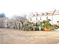
 - The Chateau of the Achard de Bonvouloir family. The main part of this castle was built in 1792. It is made from local limestone. The castle is surrounded by a large park. During World War II, this building was used as a camp. It helped thousands of injured people from the city of Caen.
- There are two Fortified Farms in Amblie:
- The Bourg farm, also called "Fiquet," looks like it's from the 1500s. It has been rebuilt many times.
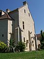
- The old Levallois farm is a typical Norman farmhouse. It has an enclosed courtyard, a dovecote (for pigeons), stables, and a bakery. It also has two old porches from the 1700s. Inside the main house, you can still see old sinks from the 1200s or 1300s. There's also a tower with a spiral staircase. This staircase is typical of the Middle Ages. During the Normandy landings, the headquarters for the First Canadian Army was located near this farm.
- The Chateau Farm from the 1800s is called the Fiquet Vallerande farm. It has a special style called Maine Anjou.
Other Interesting Places
- Old Mills: In the 1800s, Amblie had about a dozen mills along the Thue river. These mills were important for industry. They mostly ground grain. Some also pressed textiles.
- The Seulles and Thue Valleys: These are the two rivers that flow near Amblie.
- The Marettes Nature Garden: This is a special garden where people can learn how to grow vegetables together.
- The old Press: Near the Bonvouloir castle, there's an old building from the 1400s or 1500s. It used to be a press for the village. You can still see its cider tower and Wine press.
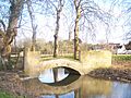
- The old Pedestrian Bridge (built in 1743). This bridge is made of local limestone. It crosses the Seulles river. It was once used by cows to cross the river.
- The Orival Stone Quarry: This is an open-air quarry where a special stone is dug out. This stone is called Orival Quarry Tile. It's very strong and resists frost better than other stones. This quarry has been important for the economy for a very long time. Stone from here was used to build famous places like Bayeux Cathedral in the 1000s and 1100s. People have been taking stone from here since the 1800s, and it's sent to many places.
- The Menhir of Planches: A menhir is a large upright stone, usually from ancient times.
The Village Church
- The Church (from the 1200s) is also a registered historical monument. This church has been rebuilt many times. Part of it, like the nave (the main part of the church), is from the 1100s. The front of the church was redone in the 1200s. In the 1800s, a new tower was added. Some of the stone carvings inside are very interesting. They show funny figures, like a huge man's head or people being bitten by strange animals. These were common jokes in the Romanesque style of art. The main entrance on the front of the church is from the 1200s. It has a special round decoration that is rare in France.
Images for kids
-
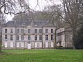
The Chateau de la Bonvouloir
-
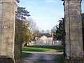
The Château des Planches of the Buisson de Courson family
-
Western gable end of the lordly manor of Amblie
-
View along the Seulles river
-
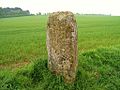
The Menhir
-
The Levallois farm
-
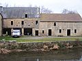
An old mill: formerly a canteen for the Canadians
-
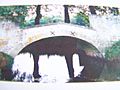
The old Creuilly limestone footbridge
-
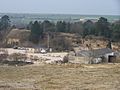
The Quarry
-
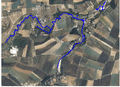
Amblie and its rivers from a satellite view. The white dot is the Orival quarry.


Famous People from Amblie
- Harry Crerar (1888-1965) was a Canadian General. He was the "Commander of the land armies" for Canada during World War II. He set up his main office in Amblie on June 18, 1944.
See also
 In Spanish: Amblie para niños
