Amboy, Minnesota facts for kids
Quick facts for kids
Amboy
|
|
|---|---|

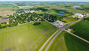
US-169 runs through town
|
|

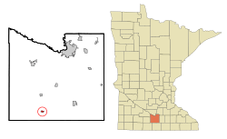
Location of Amboy, Minnesota
|
|
| Country | United States |
| State | Minnesota |
| County | Blue Earth |
| Government | |
| • Type | Mayor - Council |
| Area | |
| • Total | 0.31 sq mi (0.81 km2) |
| • Land | 0.31 sq mi (0.81 km2) |
| • Water | 0.00 sq mi (0.00 km2) |
| Elevation | 1,043 ft (318 m) |
| Population
(2020)
|
|
| • Total | 535 |
| • Density | 1,714.74/sq mi (662.78/km2) |
| Time zone | UTC-6 (Central (CST)) |
| • Summer (DST) | UTC-5 (CDT) |
| ZIP code |
56010
|
| Area code(s) | 507 |
| FIPS code | 27-01324 |
| GNIS feature ID | 2393945 |
Amboy (pronounced AM-boy) is a small city in Blue Earth County, Minnesota, in the United States. In 2020, about 535 people lived there. It is part of the larger Mankato-North Mankato area. Amboy was founded in 1879 and celebrated its 125th birthday in 2004.
Contents
History of Amboy
The area around Amboy was first organized as Shelby Township in 1858. This was the same year Minnesota became a state. People were drawn to the township because of its rich, fertile soil, which was great for farming. There were also good places to get wood along the Blue Earth River.
By 1860, Shelby Township was the most populated area in Blue Earth County. It had 315 residents and a busy village called Shelbyville. This village was located about two miles south of where Amboy is today. In the early 1860s, Shelbyville even hosted the county fair. It had many important buildings like a hotel, a church, a school, stores, and a post office.
By 1875, Shelby Township was a well-known farming area. Farmers grew grains and raised livestock. The population stayed around 800 people for the next 30 years. However, things were about to change within the township itself.
The biggest change came in 1879 when the St. Paul and Sioux City Railway decided to build a new train line. This line would run north to south through Blue Earth County. Along the planned route, many towns offered money or land to the railroad company. They wanted a train station, called a depot, in their town. The people of Shelbyville, however, voted against giving the railroad $10,000.
Just a week before that vote, a group of farmers living two miles north of Shelbyville made their own offer. They suggested buying 40 acres of land for the railroad. In return, they asked the railroad to:
- Lay out town lots (areas for building houses and businesses).
- Build a depot (train station).
- Build a grain elevator (a tall building to store grain).
The railroad accepted the farmers' offer. The new town, named Amboy, was officially planned in October 1879. This led to the end of Shelbyville. Within three years, Shelbyville was empty, as its buildings were moved to other places. Amboy became an official city in 1887. By the year 1900, it had more than 400 people living there.
Geography of Amboy
Amboy is a small city, covering about 0.31 square miles (0.81 square kilometers) of land. There is no water area within the city limits.
Two important roads run through Amboy:
- U.S. Route 169
- Minnesota State Highway 30
Climate in Amboy
Amboy experiences a climate typical of Minnesota, with warm summers and cold, snowy winters. The weather can change a lot between seasons.
| Climate data for Amboy, Minnesota, 1991–2020 normals, extremes 1905–2019 | |||||||||||||
|---|---|---|---|---|---|---|---|---|---|---|---|---|---|
| Month | Jan | Feb | Mar | Apr | May | Jun | Jul | Aug | Sep | Oct | Nov | Dec | Year |
| Record high °F (°C) | 62 (17) |
66 (19) |
84 (29) |
92 (33) |
102 (39) |
101 (38) |
101 (38) |
98 (37) |
96 (36) |
94 (34) |
82 (28) |
68 (20) |
102 (39) |
| Mean daily maximum °F (°C) | 25.5 (−3.6) |
30.2 (−1.0) |
42.8 (6.0) |
59.4 (15.2) |
72.5 (22.5) |
81.7 (27.6) |
84.1 (28.9) |
81.6 (27.6) |
75.9 (24.4) |
61.5 (16.4) |
44.2 (6.8) |
30.4 (−0.9) |
57.5 (14.2) |
| Daily mean °F (°C) | 16.9 (−8.4) |
21.2 (−6.0) |
33.5 (0.8) |
47.8 (8.8) |
60.6 (15.9) |
70.6 (21.4) |
73.4 (23.0) |
70.7 (21.5) |
63.7 (17.6) |
50.4 (10.2) |
35.3 (1.8) |
22.4 (−5.3) |
47.2 (8.4) |
| Mean daily minimum °F (°C) | 8.3 (−13.2) |
12.2 (−11.0) |
24.3 (−4.3) |
36.3 (2.4) |
48.7 (9.3) |
59.5 (15.3) |
62.6 (17.0) |
59.8 (15.4) |
51.6 (10.9) |
39.2 (4.0) |
26.4 (−3.1) |
14.3 (−9.8) |
36.9 (2.7) |
| Record low °F (°C) | −33 (−36) |
−36 (−38) |
−16 (−27) |
7 (−14) |
21 (−6) |
35 (2) |
46 (8) |
38 (3) |
26 (−3) |
14 (−10) |
−16 (−27) |
−27 (−33) |
−36 (−38) |
| Average precipitation inches (mm) | 0.83 (21) |
0.87 (22) |
1.67 (42) |
3.30 (84) |
4.27 (108) |
5.26 (134) |
4.15 (105) |
3.93 (100) |
3.34 (85) |
2.56 (65) |
1.47 (37) |
1.12 (28) |
32.77 (831) |
| Average snowfall inches (cm) | 10.4 (26) |
8.9 (23) |
7.4 (19) |
3.5 (8.9) |
0.1 (0.25) |
0.0 (0.0) |
0.0 (0.0) |
0.0 (0.0) |
0.0 (0.0) |
0.4 (1.0) |
4.8 (12) |
10.8 (27) |
46.3 (117.15) |
| Average precipitation days (≥ 0.01 in) | 5.3 | 5.2 | 6.7 | 9.4 | 10.7 | 10.7 | 8.4 | 8.0 | 6.9 | 6.9 | 5.0 | 6.6 | 89.8 |
| Average snowy days (≥ 0.1 in) | 4.3 | 4.3 | 2.5 | 1.2 | 0.1 | 0.0 | 0.0 | 0.0 | 0.0 | 0.2 | 2.0 | 5.0 | 19.6 |
| Source 1: NOAA | |||||||||||||
| Source 2: XMACIS2 | |||||||||||||
People of Amboy
The population of Amboy has changed over the years. Here's a look at how many people have lived there during different census counts:
| Historical population | |||
|---|---|---|---|
| Census | Pop. | %± | |
| 1880 | 56 | — | |
| 1890 | 215 | 283.9% | |
| 1900 | 432 | 100.9% | |
| 1910 | 435 | 0.7% | |
| 1920 | 527 | 21.1% | |
| 1930 | 593 | 12.5% | |
| 1940 | 576 | −2.9% | |
| 1950 | 585 | 1.6% | |
| 1960 | 629 | 7.5% | |
| 1970 | 571 | −9.2% | |
| 1980 | 606 | 6.1% | |
| 1990 | 517 | −14.7% | |
| 2000 | 575 | 11.2% | |
| 2010 | 534 | −7.1% | |
| 2020 | 535 | 0.2% | |
| U.S. Decennial Census 2020 Census |
|||
Amboy in 2010
In 2010, the census counted 534 people living in Amboy. There were 232 households, which are groups of people living together in one home. Out of these, 157 were families.
The city had about 1,723 people per square mile. Most of the people living in Amboy were White (96.8%). A smaller number were African American (1.3%), Native American (0.2%), or Asian (0.4%). About 5.1% of the population identified as Hispanic or Latino.
Here's more about the households in 2010:
- 26.3% of households had children under 18.
- 55.2% were married couples living together.
- 8.6% were led by a female with no husband present.
- 3.9% were led by a male with no wife present.
- 32.3% were non-family households (individuals living alone or with non-relatives).
The average household had 2.30 people, and the average family had 2.78 people. The median age in Amboy was 41.7 years old. This means half the people were younger than 41.7 and half were older.
Here's a breakdown of ages:
- 21.2% were under 18 years old.
- 9% were between 18 and 24.
- 23% were between 25 and 44.
- 28.4% were between 45 and 64.
- 18.2% were 65 years or older.
The city had slightly more males (50.7%) than females (49.3%).
Education in Amboy
Amboy used to have a school called Maple River West Middle School. This school taught students in 6th, 7th, and 8th grades. However, in 2009, the school board decided to close the middle school. They did this to save money and reorganized where students would go.
Now, elementary school students from Amboy usually go to schools in nearby towns like Minnesota Lake or Mankato. Older students, those in middle or high school, typically attend schools in Mapleton, Lake Crystal, or Mankato.
See also
 In Spanish: Amboy (Minnesota) para niños
 | Laphonza Butler |
 | Daisy Bates |
 | Elizabeth Piper Ensley |

