Amherst (CDP), New Hampshire facts for kids
Quick facts for kids
Amherst, New Hampshire
|
|
|---|---|

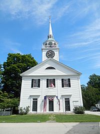
Congregational Church of Amherst
|
|
| Country | United States |
| State | New Hampshire |
| County | Hillsborough |
| Town | Amherst |
| Area | |
| • Total | 0.73 sq mi (1.88 km2) |
| • Land | 0.73 sq mi (1.88 km2) |
| • Water | 0.00 sq mi (0.00 km2) |
| Elevation | 264 ft (80 m) |
| Population
(2020)
|
|
| • Total | 697 |
| • Density | 960.06/sq mi (370.50/km2) |
| Time zone | UTC-5 (Eastern (EST)) |
| • Summer (DST) | UTC-4 (EDT) |
| ZIP code |
03031
|
| Area code(s) | 603 |
| FIPS code | 33-01220 |
| GNIS feature ID | 2629710 |
Amherst is a special kind of community called a census-designated place (CDP). It's like the main village in the bigger town of Amherst in Hillsborough County, New Hampshire, United States. In 2020, about 697 people lived in this village center. The whole town of Amherst had over 11,753 residents. The heart of Amherst village is so important that it's listed on the National Register of Historic Places as the Amherst Village Historic District. This means it has a lot of history and special buildings!
Exploring Amherst Village
The village of Amherst is located right in the middle of the larger town of Amherst. It's bordered by New Hampshire Route 101 to the east. To the south, you'll find Thornton Ferry Road, Courthouse Road, and Atherton Lane. Old Milford Road and the western edge of Meadow View Cemetery are to the west. To the north, you'll see Jones Road, Mack Hill Road, and Manchester Road.
Route 101 is an important road. It goes northeast about 10 miles (16 km) to the start of the Manchester bypass. If you go southwest on Route 101 for about 10 miles (16 km), you'll reach Wilton. Another nearby town, Milford, is about 2.5 miles (4.0 km) southwest via Amherst Street.
The Amherst CDP covers a total area of about 0.73 square miles (1.88 km2). All of this area is land, with no large bodies of water inside the village limits.
Who Lives in Amherst?
| Historical population | |||
|---|---|---|---|
| Census | Pop. | %± | |
| 2010 | 613 | — | |
| 2020 | 697 | 13.7% | |
| U.S. Decennial Census | |||
Let's look at the people who live in Amherst village. In 2010, there were 613 people living here. By 2020, the population grew to 697 people.
Most people living in the CDP are white, making up about 99% of the population in 2010. There were also small numbers of Asian residents and people from two or more races. About 0.8% of the population identified as Hispanic or Latino.
In 2010, there were 241 households in Amherst village. A household is a group of people living together in one home. About 38% of these households had children under 18 living with them. Most households (about 65%) were married couples living together.
The average age of people in Amherst village in 2010 was about 45.6 years old. About 27% of residents were under 18. About 20% were 65 years old or older.
The average yearly income for a household in Amherst village between 2011 and 2015 was quite high, around $112,344. This shows that Amherst is a prosperous community.
See also
 In Spanish: Amherst (condado de Hillsborough) para niños
 | Delilah Pierce |
 | Gordon Parks |
 | Augusta Savage |
 | Charles Ethan Porter |


