
Anacapa Island Light facts for kids
 |
|

Anacapa Island Light
Location in California

Anacapa Island Light
Location in the United States
|
|
| Location | Anacapa Island Ventura County California United States |
|---|---|
| Coordinates | 34°00′57″N 119°21′34″W / 34.015827°N 119.359548°W |
| Year first constructed | 1912 (first) |
| Year first lit | 1932 (current) |
| Automated | 1968 |
| Foundation | brick and concrete base |
| Construction | reinforced concrete tower |
| Tower shape | cylindrical tower with balcony and lantern |
| Markings / pattern | white tower, black lantern |
| Height | 55 feet (17 m) |
| Focal height | 277 feet (84 m) |
| Original lens | Third order Fresnel lens |
| Current lens | DCB-24 aerobeacon |
| Characteristic | Fl (2) W 60s. |
| Fog signal | blast every 15s. |
| Admiralty number | G3940 |
| ARLHS number | USA-012 |
| USCG number | 6-0185 |
The Anacapa Island Lighthouse is a famous lighthouse in California, United States. It stands on Anacapa Island, guiding ships into the Santa Barbara Channel. Built in 1912, it was one of the last major lighthouses made on the West Coast.
Anacapa Island and other nearby islands became the Channel Islands National Monument in 1938. The lighthouse still works today, but it is fully automated. This means no one lives there to operate it. The National Park Service (NPS) now manages the island as part of the Channel Islands National Park.
Anacapa Island is also known for a successful environmental project. The NPS worked to remove non-native rats that were harming local wildlife. This program started in 2003. By 2014, the island was declared rat-free. This helped native animals and plants to thrive again.
History
Anacapa Island was a perfect spot for a lighthouse. It sits at the eastern entrance to the Santa Barbara Channel. The Lighthouse Board decided to put a light there. To save money, they first built an unmanned light in 1912. This light used an acetylene lens lantern on a tower.
In 1932, the current lighthouse was built. It was the last major light station built on the West Coast. The lighthouse tower is 39-foot (12 m) tall. It also has a fog signal. Both were built on the highest point of the island.
In 1938, President Franklin D. Roosevelt made Santa Barbara and Anacapa Islands a national monument. It was called the Channel Islands National Monument. The United States Coast Guard made the lighthouse automatic in 1966. This meant lighthouse keepers were no longer needed.
In 1980, Congress created the Channel Islands National Park. This park includes five of the eight Channel Islands. These are Anacapa, Santa Cruz, Santa Rosa, San Miguel, and Santa Barbara Island. It also includes 125,000 acres (51,000 ha) of underwater lands. The Anacapa Island Lighthouse still helps ships navigate today.
Island's Name and Features
The name "Anacapa" comes from a native-American word. It means "ever changing." Juan Rodríguez Cabrillo first explored the islands in 1542. Later, Captain George Vancouver renamed them Anacapa. This name came from the local Chumash people.
Anacapa Island is actually a chain of three small islands. They stretch about four and a half miles from east to west. The eastern island is about one mile long and rises 250 feet (76 m) high. The middle island is one and a half miles long and 325 feet (99 m) high. The western island is the largest. It is two miles long and rises to 930 feet (280 m).
The lighthouse tower and foghorn building are on East Anacapa. Since 1932, its bright light and loud foghorn have guided ships. The light flashes white twice every 60 seconds. The foghorn blasts twice for two seconds each, with short silences in between. It then stays silent for 14 seconds. Before the lighthouse became automatic in 1968, Coast Guard families lived in houses nearby.
Current usage
The National Park Service now uses the buildings near the lighthouse. These buildings help them manage the park.
Geography
Anacapa is the smallest of the Channel Islands. It is also the closest to the mainland. It is about 9 miles (14 km) across the Santa Barbara Channel. It lies southwest of the city of Ventura.
Image gallery
-
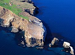
Aerial photo 2009
-
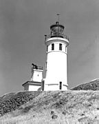
U.S. Coast Guard archive photo.
-
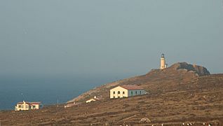
Lighthouse and National Park structures at sunset.
-
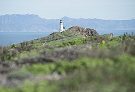
Looking across Santa Barbara Channel towards mainland, 2019.


