Anchor, Illinois facts for kids
Quick facts for kids
Anchor, Illinois
|
|
|---|---|

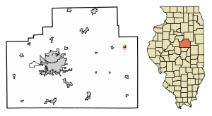
Location in McLean County, Illinois
|
|
| Country | United States |
| State | Illinois |
| County | McLean |
| Township | Anchor |
| Area | |
| • Total | 0.17 sq mi (0.44 km2) |
| • Land | 0.17 sq mi (0.44 km2) |
| • Water | 0.00 sq mi (0.00 km2) |
| Elevation | 774 ft (236 m) |
| Population
(2020)
|
|
| • Total | 163 |
| • Density | 953.22/sq mi (368.44/km2) |
| Time zone | UTC-6 (CST) |
| • Summer (DST) | UTC-5 (CDT) |
| ZIP code |
61720
|
| Area code(s) | 309 |
| FIPS code | 17-01361 |
| GNIS ID | 2397959 |
Anchor is a small village located in McLean County, Illinois, United States. In 2020, about 163 people lived there. It's considered part of the larger Bloomington-Normal area.
Where is Anchor, Illinois?
Anchor is located in the eastern part of McLean County. It is south of Illinois Route 165. The city of Bloomington, which is the main city in the county, is about 28 miles (45 km) to the west. Another town, Sibley, is about 9 miles (14 km) to the east.
The village covers a total area of about 0.17 square miles (0.44 square kilometers). All of this area is land. Water from the village flows south into the Mackinaw River. This river eventually flows west into the larger Illinois River.
The Story of Anchor Village
Anchor was officially started on April 28, 1880. A man named Daniel B. Stewart, who owned a lot of land in the area, helped create the town. He was born in New York and moved to Illinois in the early 1860s.
Stewart and others gave $10,000 to help build ten miles of a new railroad. The town of Anchor was created when the Clinton Bloomington and Northeastern Railroad was built. Other nearby towns like Colfax, Cropsey, and Cooksville were also started around the same time. This railroad soon became part of the Illinois Central railroad system.
The very first trains passed through Anchor on July 4, 1880. The village got its name from Anchor Township, the area it is in. Early historians of McLean County were not sure how the name "Anchor" first came about.
When Anchor was first planned, it was a rectangle shape. It stretched out on both sides of the railroad tracks. A small triangle-shaped area north of the tracks was called "Depot Park." The train station was on the north side of the tracks. Two grain elevators, which are tall buildings for storing grain, were on the south side. Most of the first shops and businesses were on the north side of Second Street. By 1895, there was a brick factory and a coal mine nearby. There were also a few stores and a hotel called the Morris Hotel.
Population Facts
Here's how Anchor's population has changed over the years:
| Historical population | |||
|---|---|---|---|
| Census | Pop. | %± | |
| 1880 | 32 | — | |
| 1960 | 194 | — | |
| 1970 | 200 | 3.1% | |
| 1980 | 192 | −4.0% | |
| 1990 | 178 | −7.3% | |
| 2000 | 175 | −1.7% | |
| 2010 | 146 | −16.6% | |
| 2020 | 163 | 11.6% | |
| Decennial US Census | |||
In 2000, there were 175 people living in Anchor. These people lived in 65 different homes, and 47 of those were families. About 33.8% of the homes had children under 18 living there. Most homes, 67.7%, were married couples living together. About 23.1% of all homes were single individuals.
The average home had about 2.69 people, and the average family had about 3.17 people. In terms of age, about 32% of the population was under 18. About 22.3% of the people were 65 years old or older. The average age in the village was 39 years old.
See also
 In Spanish: Anchor (Estados Unidos) para niños
 | Sharif Bey |
 | Hale Woodruff |
 | Richmond Barthé |
 | Purvis Young |


