Angel City, Florida facts for kids
Quick facts for kids
Angel City
|
|
|---|---|
| Country | United States |
| State | Florida |
| County | Brevard |
| Post Office founded | 1927 |
| Elevation | 0 ft (0 m) |
| ZIP code |
32952
|
| Area code(s) | 321 |
Angel City is a small community located on the Horti Point peninsula of Merritt Island. It's in Brevard County, Florida, United States. Angel City had its own post office for a short time, from 1927 to 1931.
People believe the community was named after an early settler. Some say it was named for John Angel. Others say Hattie Worley, whose husband Oscar was a bridge tender, named it after Captain Angel from Rhode Island. He was one of the first people to build a home there.
Connecting Angel City: The Old Bridge Story

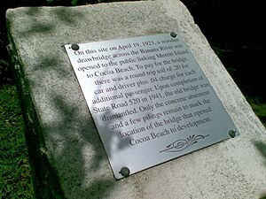
From 1922 to 1941, a wooden drawbridge connected Cocoa Beach to Angel City. This bridge was part of the Merritt Island Causeway. To use the bridge, drivers had to pay a small fee, called a toll. It cost 20 cents for a car and driver, plus 4 cents for each extra passenger.
A special plaque marks the spot where this old bridge once stood. It tells us that the bridge opened on April 19, 1923. It was very important because it helped Cocoa Beach grow. When State Road 520 was finished in 1941, the old wooden bridge was taken down. Today, you can still see some concrete parts and old pilings that show where it used to be.
Oscar Worley was the person who collected the tolls at this bridge. He worked there until the new SR 520 opened on June 5, 1941. Sadly, Oscar didn't get to work at the new bridge. Instead, he started a fish business in Angel City. He lived there until he passed away in 1956 at age 83.
The Worley family was one of the first to settle in Angel City. A road called Worley Avenue is named after them. The Worley family still lives in Angel City today. Interestingly, Oscar Worley's grandson, Donald Worley, was born right on the bridge! His birth certificate even says his place of birth was "Banana River toll bridge."
Exploring Angel City's Surroundings
Angel City is surrounded by water on three sides. To the south and east, you'll find the Banana River. To the west, there's Newfound Harbor. To the north, you'll see SR 520. Buck Point is the southernmost tip of the peninsula, where Newfound Harbor meets the Banana River.
South of Buck Point, there are two islands that no one lives on. They are called Brady and George's islands. You can reach them from nearby communities like Lotus and Georgiana. These islands were created from sand and dirt that was dug up from the water.
The southern island is often called Bird Island by local people. It's a popular spot for boating, camping, and other fun activities. It's not just called Bird Island because of the many birds there. From high up in the air, the island actually looks like a pelican flying!
These islands are great places to spot amazing wildlife. You might see gentle manatees and playful dolphins swimming in the water. Many birds also live here, like pelicans, great blue herons, and seagulls. You might also spot southern stingrays and even rat snakes. In late winter, you can see white pelicans during their migratory journey.
The Intracoastal Waterway passes by the north and east sides of the islands. To the west, you'll find Lotus, which is also known as Honeymoon Hill. If you look south, you can see the Pineda Causeway. To the east is Patrick Space Force Base.
 | Toni Morrison |
 | Barack Obama |
 | Martin Luther King Jr. |
 | Ralph Bunche |


