
Anzac Parade, Sydney facts for kids
Quick facts for kids Anzac ParadeNew South Wales |
|
|---|---|
 |
|
| Bunnerong Road ,Kingsford | |
| General information | |
| Type | Road |
| Length | 13.5 km (8.4 mi) |
| Opened | 1917 |
| Gazetted | August 1928 |
| Former route number |
|
| Major junctions | |
| North end | Flinders Street Moore Park, Sydney |
|
|
| South end | No through road La Perouse, Sydney |
| Location(s) | |
| Major suburbs | Kensington, Kingsford, Maroubra, Matraville, Malabar, Chifley, Little Bay |

Anzac Parade is a really important road in Sydney, Australia. It's in the south-eastern part of the city. This road is named to remember the brave soldiers, called Anzacs, who marched along it during World War I. They were heading to Sydney Harbour to sail off to Europe. Many of these soldiers were part of the First Australian Imperial Force. Their barracks, where they lived, are now a historic part of the University of New South Wales.
Contents
What is Anzac Parade Like?
Anzac Parade starts in Moore Park, near the Eastern Distributor highway. It heads south as a big road with six lanes. As you travel along it, the road goes through several suburbs like Kensington, Kingsford, Maroubra, and Matraville.
Further south, it passes through Malabar, Chifley, and Little Bay. Near the end, it becomes a smaller, two-lane road. The road finally ends in La Perouse.
Along Anzac Parade, you'll see some important places. These include the University of New South Wales and the National Institute of Dramatic Art (NIDA). You can also find Pacific Square in Maroubra.
This road was even part of the marathon route during the 2000 Summer Olympics held in Sydney. You can still see a blue line on the road that marks the marathon's path!
History of the Road
Anzac Parade wasn't always one long road. It used to be several smaller streets that were joined together. In 1917, these different streets were given the single name "Anzac Parade" to honour the soldiers.
Some of its old names included:
- Randwick Road (between Moore Park and Alison Road)
- Eastern Avenue (in Kensington)
- Bunnerong Road (in Kingsford and Little Bay)
- Broad Road (between Kingsford and Little Bay)
Later, in 1934, a street called Quambi Avenue in La Perouse was also added to Anzac Parade.
The government officially recognised Anzac Parade as an important "Main Road" in 1928. This meant the state government helped fund its upkeep. In 2015, a new bridge called the Albert Cotter Bridge was built over Anzac Parade. This bridge helps people walk and cycle safely to events at the Sydney Cricket Ground and Sydney Football Stadium.
Getting Around on Anzac Parade

Anzac Parade is a very busy route for public transport. Many Transdev John Holland buses use this road. They can take you to the city, Railway Square, Bondi Junction, and many suburbs along the road like Maroubra, Coogee, and La Perouse. There are special bus lanes to help buses move faster.
In recent years, a new way to travel was built: the CBD and South East Light Rail. Construction started in 2015. This light rail line runs from Circular Quay in the city centre, through George Street, and then crosses Moore Park to follow Anzac Parade.
The light rail splits into two branches. One branch continues down Anzac Parade to Kingsford, opening in 2020. The other branch goes to Randwick and opened in 2019. For a while, parts of Anzac Parade had to be temporarily changed to allow for the light rail tunnel to be built underneath.
Before the light rail, there used to be a tram service along Anzac Parade. The wide grassy area in the middle of the road, especially south of Kingsford, was where the trams used to run. The tram line closed in 1961, and buses took over the route.
Images for kids
-
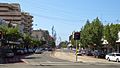
Bunnerong Road in Kingsford, part of Anzac Parade.
