Appila, South Australia facts for kids
Quick facts for kids AppilaSouth Australia |
|||||||||||||||
|---|---|---|---|---|---|---|---|---|---|---|---|---|---|---|---|

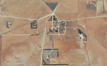
Aerial view of Appila, 2015
|
|||||||||||||||
| Established | 1874 | ||||||||||||||
| Postcode(s) | 5480 | ||||||||||||||
| Location |
|
||||||||||||||
| LGA(s) | Mount Remarkable | ||||||||||||||
| State electorate(s) | Stuart | ||||||||||||||
| Federal Division(s) | Grey | ||||||||||||||
|
|||||||||||||||
Appila is a small place in the Mid North region of South Australia. It is located east of the lower Flinders Ranges. This area covers most of the eastern part of the Hundred of Appila. It also includes a strip on the western side of the nearby Hundred of Tarcowie. Appila was once known by the name Yarrowie.
Contents
History of Appila
How Appila Was Settled
The town was first called Yarrowie. This name comes from an Aboriginal word meaning "hunting ground." It was started in 1872. This happened after a law called the Strangways Land Act was made in 1869. This law helped people settle closer together on the land.
Growth of the Early Town
The town of Yarrowie grew very quickly. Many settlers moved to the area. By the 1880s, it was a busy place. It had two hotels where people could stay. There were also four blacksmiths who worked with metal. Three carpenters built and fixed things. The town had different schools, including Protestant, Catholic, and government schools. A post office and telegraph station helped people communicate. There were also other stores for daily needs.
Why the Name Changed
In 1877, the town's name was changed. It became Appila-Yarrowie first, and then just Appila. This change was made to avoid confusion. There were other towns nearby with similar-sounding names. These included Yarcowie, Tarcowie, Terowie, Caltowie, and Willowie.
Schools in Appila
Appila had several schools. One of them was a Lutheran school. In 1918, this school was closed by the state government. At that time, 33 students were attending the school.
 | Claudette Colvin |
 | Myrlie Evers-Williams |
 | Alberta Odell Jones |


