Archdale, North Carolina facts for kids
Quick facts for kids
Archdale, North Carolina
|
|||||
|---|---|---|---|---|---|
|
|||||
| Motto(s):
"Crossroad of progress"
|
|||||

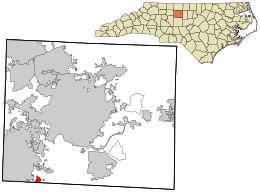
Location in Guilford County and the state of North Carolina
|
|||||
| Country | United States | ||||
| State | North Carolina | ||||
| Counties | Randolph, Guilford | ||||
| Founded | 1786 | ||||
| Incorporated | 1874, 1969 | ||||
| Named for | John Archdale | ||||
| Area | |||||
| • Total | 8.86 sq mi (22.95 km2) | ||||
| • Land | 8.84 sq mi (22.89 km2) | ||||
| • Water | 0.02 sq mi (0.06 km2) | ||||
| Elevation | 804 ft (245 m) | ||||
| Population
(2020)
|
|||||
| • Total | 11,907 | ||||
| • Density | 1,347.25/sq mi (520.15/km2) | ||||
| Time zone | UTC-5 (Eastern (EST)) | ||||
| • Summer (DST) | UTC-4 (EDT) | ||||
| ZIP code |
27263
|
||||
| Area code(s) | 336 | ||||
| FIPS code | 37-01720 | ||||
| GNIS feature ID | 2403108 | ||||
Archdale is a city in North Carolina, a state in the United States. It is located in both Guilford and Randolph counties.
Archdale is about 15 miles southwest of Greensboro. It is part of the larger Greensboro-High Point area. In 2020, about 11,907 people lived in Archdale.
Contents
Where is Archdale Located?
Archdale is mostly in Randolph County. A small part of the city reaches into Guilford County. The city of Trinity is to its southwest. High Point is to its north.
Major Roads in Archdale
Interstate 85 goes through Archdale. This highway can take you northeast to Greensboro. It also goes southwest to Charlotte.
Interstate 74 passes just east of Archdale. This road leads northwest to Winston-Salem. It also goes southeast to Asheboro.
Waterways in Archdale
Archdale has a total area of about 8.8 square miles. A very small part of this area is water. The city is in the area drained by the Deep River. This river flows into the Cape Fear River. Muddy Creek also starts within Archdale.
How Many People Live in Archdale?
| Historical population | |||
|---|---|---|---|
| Census | Pop. | %± | |
| 1890 | 224 | — | |
| 1900 | 182 | −18.7% | |
| 1910 | 145 | −20.3% | |
| 1920 | 178 | 22.8% | |
| 1930 | 628 | 252.8% | |
| 1940 | 1,097 | 74.7% | |
| 1950 | 1,218 | 11.0% | |
| 1960 | 1,520 | 24.8% | |
| 1970 | 4,874 | 220.7% | |
| 1980 | 5,326 | 9.3% | |
| 1990 | 6,913 | 29.8% | |
| 2000 | 9,014 | 30.4% | |
| 2010 | 11,415 | 26.6% | |
| 2020 | 11,907 | 4.3% | |
| 2022 (est.) | 12,003 | 5.2% | |
| U.S. Decennial Census | |||
Population in 2020
In 2020, there were 11,907 people living in Archdale. There were 4,596 households and 2,977 families.
Population in 2010
In 2010, the city had 11,415 people. There were 4,556 households. About 30.7% of these households had children under 18.
The population was spread out by age. About 23.8% of people were under 18 years old. About 15.6% were 65 years or older. The average age in the city was 40 years.
History of Archdale
Archdale was first known as "Bush Hill." It started as a settlement mainly for Quaker people. The city was named "Archdale" to honor John Archdale. He was an early Quaker governor.
Archdale officially became a city in July 1969. The people living there voted to become a city. This helped them get important services like water and sewer systems.
Historic Places and People
Two important historic homes in Archdale are listed on the National Register of Historic Places. These are the Moses Hammond House and the Harper House.
Jerry W. Tillman (1940–2023) was a politician from North Carolina. He was born in Archdale.
Fun Things to Do in Archdale
- Creekside Park, managed by Archdale Parks and Recreation
- Kersey Valley
- The Bush Hill Festival
See also
 In Spanish: Archdale para niños


