Arenig Fach facts for kids
Quick facts for kids Arenig Fach |
|
|---|---|

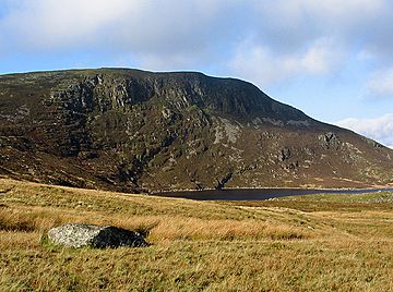
The north-eastern face of Arenig Fach
|
|
| Highest point | |
| Elevation | 689 m (2,260 ft) |
| Prominence | 294 m (965 ft) |
| Parent peak | Arenig Fawr |
| Listing | Marilyn, Hewitt, Nuttall |
| Naming | |
| English translation | Small High Ground |
| Language of name | Welsh |
| Geography | |
| Location | Gwynedd, Wales |
| Parent range | Snowdonia |
| OS grid | SH827370 |
| Topo map | OS Landranger 124 |
Arenig Fach is a mountain located in the southern part of Snowdonia, a beautiful national park in north Wales. It's part of the Arenig mountain range. This mountain sits to the north of its larger neighbor, Arenig Fawr.
Exploring Arenig Fach
Arenig Fach is a mountain that stands 689 meters (about 2,260 feet) tall. It's known as a "Marilyn," "Hewitt," and "Nuttall," which are special lists for hills and mountains in the UK based on their height and how much they rise above the land around them. Its name, "Arenig Fach," comes from the Welsh language and means "Small High Ground."
Where is Arenig Fach?
This mountain is found in Gwynedd, a county in Wales. It's located near Llyn Celyn, a large reservoir. You can find it close to the A4212 highway, which connects the towns of Trawsfynydd and Bala.
From a distance, Arenig Fach might look like a big, rounded hill. It rises from an area of moorland called the Migneint.
What's at the Top?
The very top of Arenig Fach is called Carnedd Bachgen. This name comes from an old stone pile, or cairn, called Carnedd y Bachgen, which is just a bit north-east of the highest point.
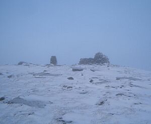
At the summit, you'll find a trig point. This is a special pillar used by surveyors to measure distances and map the land. There's also a large stone shelter built there. This shelter helps protect hikers from the wind and weather.
The Mountain's Look
While much of Arenig Fach looks like a bulky, heather-covered hill, its north-eastern side is quite different. Here, you'll see steep cliffs. At the bottom of these cliffs is a small lake called Llyn Arenig Fach. This type of lake, formed in a bowl-shaped hollow, is known as a corrie lake.
Scientists believe that the last time glaciers were in this corrie was during a cold period called the Loch Lomond Stadial. This was a time when ice covered parts of the land.
 | Janet Taylor Pickett |
 | Synthia Saint James |
 | Howardena Pindell |
 | Faith Ringgold |


