Arenig Fawr facts for kids
Quick facts for kids Arenig Fawr |
|
|---|---|

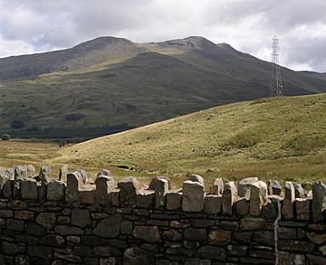
Arenig Fawr from the A4212 to Ffestiniog.
|
|
| Highest point | |
| Elevation | 854 m (2,802 ft) |
| Prominence | 479 m (1,572 ft) |
| Parent peak | Moel Siabod |
| Listing | Marilyn, Hewitt, Nuttall |
| Naming | |
| English translation | Great High Ground |
| Language of name | Welsh |
| Geography | |
| Location | Gwynedd, Wales |
| Parent range | Snowdonia |
| OS grid | SH827370 |
| Topo map | OS Landranger 124 |
Arenig Fawr (which means "Great High Ground" in Welsh) is a cool mountain located in Snowdonia, North Wales. It stands close to the Llyn Celyn reservoir. You can find it near the A4212 between the towns of Trawsfynydd and Bala.
Contents
Where is Arenig Fawr Located?
Arenig Fawr is the tallest mountain in the Arenig mountain group. A smaller mountain nearby, called Arenig Fach, is to the north. Its name means "Small High Ground". Arenig Fawr is surrounded by other mountains. These include Moel Llyfnant to the west and Rhobell Fawr to the south. Mynydd Nodol is to the east.
Climbing to the Top of Arenig Fawr
It takes about 2½ hours to climb to the top of Arenig Fawr from Llyn Celyn. This climb is considered easy to medium difficulty. There aren't clear walking paths, but an old wire fence helps guide the way.
The Lake Below the Mountain
Below the mountain is Llyn Arenig Fawr. This is a reservoir that holds drinking water. It supplies water to Bala and other nearby villages.
The Summit and its Memorial
The very top of the mountain is also known as Moel yr Eglwys. This means "Bare hill of the church". At the summit, you'll find a trig point. This is a special marker used for surveying.
There is also a memorial at the top. It remembers eight American aircrew members. Their Flying Fortress bomber plane crashed here on August 4, 1943. You can still see some parts of the plane wreckage scattered on the hillside. They are about 300 meters (330 yards) from the memorial.
Amazing Views from the Summit
If the weather is good, the views from the top are incredible! You can see many famous Welsh mountain ranges. To the west, you might spot the Rhinogs. Snowdon is visible to the northwest. The Clwydian Hills are in the northeast. You can see the Berwyns to the east. The Arans are to the southeast. And to the south, you can see Cadair Idris. Many people say this is one of the best views in all of Wales.
On very clear days, you might even see further! You could spot the Wicklow Mountains in Ireland. The Blackpool Tower in England might be visible. Some peaks from the Peak District near Manchester can be seen. You might also see parts of the Lake District and the Brecon Beacons. The furthest peaks ever seen include Cross Fell and Great Dun Fell in Cumbria. Mountains in the Mourne Mountains of Northern Ireland and Blackstairs Mountain in Republic of Ireland have also been spotted.
The Old Railway Line
There used to be a train stop called Arenig Halt. It was a "request stop" on the Bala Ffestiniog Line. This meant the train would only stop if someone asked. It stopped carrying passengers in 1960 and freight in 1961. Today, there are no buildings left from the station.
Arenig Fawr in Art and Stories
Arenig Fawr has inspired artists and writers. Artists James Dickson Innes and Augustus John painted in the Arenig valley. They used the mountain as a background for their art between 1911 and 1912. A BBC show in 2011, called The Mountain That Had to Be Painted, was about their work.
The mountain is also mentioned in an old English poem. It's called The Faerie Queene by Sir Edmund Spenser. In the poem, a wise old character lives "Under the foot of Rauran mossy hore". A historian, Sir John Edward Lloyd, believed "Rauran" was actually a name for Arenig Fawr.
There's even a special boulder in a small village in England. It's in Bell Heath, near Belbroughton, Worcestershire. A brass plaque on the boulder says it came from Arenig Mountain. It was carried there by a huge sheet of ice during the Ice Age!
 | Sharif Bey |
 | Hale Woodruff |
 | Richmond Barthé |
 | Purvis Young |

