Mynydd Nodol facts for kids
Quick facts for kids Mynydd Nodol |
|
|---|---|
 |
|
| Highest point | |
| Elevation | 539 m (1,768 ft) |
| Prominence | 168 m (551 ft) |
| Listing | Marilyn |
| Naming | |
| English translation | nodal hill |
| Language of name | Welsh |
| Geography | |
| Location | Gwynedd, Wales |
| Parent range | Arenigs |
| OS grid | SH865393 |
| Topo map | OS Landranger 124 / Explorer OL18 |
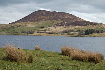
Mynydd Nodol is a hill that stands 539 meters (about 1,768 feet) tall. It is located in the beautiful Snowdonia National Park in North Wales. Specifically, it is found in the area known as Llanycil within the county of Gwynedd.
This hill rises above the southern edge of Llyn Celyn, which is a large reservoir. It is about 4 kilometers (2.5 miles) northeast of a taller mountain called Arenig Fawr. Mynydd Nodol creates a stunning view from the car park near the dam on the A4212 road. The hill also has a wide slope that extends towards the east.
What Mynydd Nodol is Made Of
Mynydd Nodol is mostly made from very old volcanic rocks. These rocks are called "acid ash-flow tuffs" and belong to the Llyn Conwy Formation. They were formed during the Ordovician period, which was hundreds of millions of years ago. These strong volcanic rocks are also found in many other hills and mountains nearby.
Beneath the eastern slopes of the hill, you can find softer rocks called "mudstones." These mudstones are part of the Nant Hir Formation. There are also some areas where different types of volcanic rock, called "quartz-latite," stick out of the ground. However, much of the lower ground is covered by "glacial till," which is a mix of rock and soil left behind by ancient glaciers.
For about 40 years, starting in 1867, people mined for manganese on the northern and western sides of Mynydd Nodol. You can still see abandoned mining tunnels and piles of waste rock from those days.
Exploring Mynydd Nodol
Almost all of Mynydd Nodol is considered "open country." This means that, thanks to the Countryside and Rights of Way Act 2000, people are allowed to walk freely across most of the hill. You can explore and enjoy the natural beauty of the area.
To get close to the hill, there is a small public road that runs northwest from Bala. This road goes along the southwestern edge of Mynydd Nodol.
 | Laphonza Butler |
 | Daisy Bates |
 | Elizabeth Piper Ensley |

