Arenig Fawr South Ridge Top facts for kids
Quick facts for kids Arenig Fawr South Ridge Top |
|
|---|---|

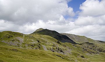
Arenig Fawr South Ridge Top from the south
|
|
| Highest point | |
| Elevation | 712 m (2,336 ft) |
| Prominence | 18 m (59 ft) |
| Parent peak | Arenig Fawr |
| Listing | Nuttall |
| Naming | |
| English translation | Great High Ground |
| Language of name | Welsh |
| Geography | |
| Location | Gwynedd, Wales |
| Parent range | Snowdonia |
| OS grid | SH827370 |
| Topo map | OS Landranger 124 |
Arenig Fawr South Ridge Top is a special part of a larger mountain called Arenig Fawr. This mountain is located in the beautiful area of Snowdonia in North Wales. It's like a smaller peak or a high point on the side of the main mountain.
This spot is found on the wide southern side of Arenig Fawr. It's an interesting place with rocky hills and small lakes called tarns.
Contents
Discovering Arenig Fawr South Ridge Top
This area is known for its rugged and natural beauty. It's a great place for exploring if you enjoy being outdoors.
What is a "Top"?
In the world of mountains, a "top" is a high point or a smaller peak that is part of a larger mountain. It's not quite the main summit, but it's still a significant high spot. Arenig Fawr South Ridge Top is the highest rocky part in its area.
The Summit and Its Views
The very top of Arenig Fawr South Ridge Top is marked by a few stones. From here, the views are a bit limited. This is because the huge size of Arenig Fawr itself blocks some of the scenery. However, you can still enjoy the feeling of being high up in the mountains.
Exploring the Area
There is a path that goes down the western side of this ridge. This path leads towards another interesting spot called Moel Llyfnant. Exploring these paths can be a fun adventure for hikers.
 | Valerie Thomas |
 | Frederick McKinley Jones |
 | George Edward Alcorn Jr. |
 | Thomas Mensah |

