
Arlington, Georgia facts for kids
Quick facts for kids
Arlington, Georgia
|
|
|---|---|

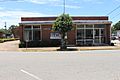
City hall and police station
|
|

Location in Calhoun County and the state of Georgia
|
|

Arlington, Georgia
Location in Georgia (U.S. state)

Arlington, Georgia
Location in the United States

Arlington, Georgia
Location in North America
|
|
| Country | United States |
| State | Georgia |
| Counties | Calhoun, Early |
| Area | |
| • Total | 4.01 sq mi (10.38 km2) |
| • Land | 4.00 sq mi (10.35 km2) |
| • Water | 0.01 sq mi (0.03 km2) |
| Elevation | 299 ft (91 m) |
| Population
(2020)
|
|
| • Total | 1,209 |
| • Density | 302.48/sq mi (116.79/km2) |
| Time zone | UTC-5 (Eastern (EST)) |
| • Summer (DST) | UTC-4 (EDT) |
| ZIP codes |
31713, 39813
|
| Area code(s) | 229 |
| FIPS code | 13-02928 |
| GNIS feature ID | 0310614 |
Arlington is a small city in the state of Georgia, United States. It is special because it is located in two different counties: Calhoun County and Early County. In 2020, about 1,209 people lived there.
Contents
History of Arlington
Arlington was started in 1873. It officially became a city in 1881. For a short time, from 1923 to 1929, Arlington was the main town, or "county seat," for Calhoun County. The city was named after the famous Arlington House in Virginia. This house was the home of General Robert E. Lee.
Geography of Arlington
Arlington is located in southwest Georgia. You can find it at these coordinates: 31°26′22″N 84°43′29″W / 31.43944°N 84.72472°W. It is about 46 miles northeast of Dothan, Alabama. It is also about 45 miles southwest of Albany.
The city covers a total area of about 10.7 square kilometers (4.1 square miles). Most of this area is land. Only a tiny part, about 0.03 square kilometers (0.01 square miles), is water. Arlington is mainly in Calhoun and Early counties. It also shares a border with Baker County to its east.
Population and People
The number of people living in Arlington has changed over the years.
| Historical population | |||
|---|---|---|---|
| Census | Pop. | %± | |
| 1880 | 250 | — | |
| 1890 | 417 | 66.8% | |
| 1900 | 755 | 81.1% | |
| 1910 | 1,308 | 73.2% | |
| 1920 | 1,331 | 1.8% | |
| 1930 | 1,232 | −7.4% | |
| 1940 | 1,337 | 8.5% | |
| 1950 | 1,382 | 3.4% | |
| 1960 | 1,462 | 5.8% | |
| 1970 | 1,698 | 16.1% | |
| 1980 | 1,572 | −7.4% | |
| 1990 | 1,513 | −3.8% | |
| 2000 | 1,602 | 5.9% | |
| 2010 | 1,479 | −7.7% | |
| 2020 | 1,209 | −18.3% | |
| U.S. Decennial Census 1850-1870 1870-1880 1890-1910 1920-1930 1940 1950 1960 1970 1980 1990 2000 2010 2020 |
|||
In 2010, the city had 1,479 residents. By the 2020 census, the population went down to 1,209 people.
The people living in Arlington come from different backgrounds. In 2020, most residents were Black or African American. A smaller group was White. There were also a few people from other racial or ethnic groups.
Education in Arlington
Students in Arlington attend schools in two different school districts. This depends on which county they live in.
Calhoun County Schools
If students live on the Calhoun County side of Arlington, they are part of the Calhoun County School District.
- Calhoun County Elementary School teaches students from kindergarten to 5th grade. Some students from Arlington go here.
- Calhoun County Middle/High School is located in the nearby town of Edison.
Early County Schools
Students living on the Early County side of Arlington go to schools in the Early County School District. All of these schools are located in Blakely. This includes Early County High School.
Notable Person
- James Earl Carter, Sr. – He was a farmer, a businessman, and a politician. He was also the father of former U.S. President Jimmy Carter.
Gallery
-
Arlington Post Office

See also
 In Spanish: Arlington (Georgia) para niños
