Arnett, Oklahoma facts for kids
Quick facts for kids
Arnett, Oklahoma
|
|
|---|---|

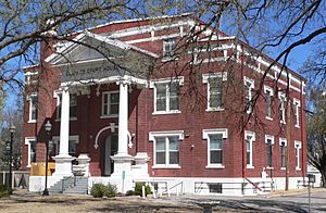
Ellis County courthouse
|
|

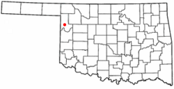
Location of Arnett within Oklahoma
|
|
| Country | United States |
| State | Oklahoma |
| County | Ellis |
| Founded | 1900 |
| Incorporated | 1909 |
| Area | |
| • Total | 0.52 sq mi (1.34 km2) |
| • Land | 0.52 sq mi (1.34 km2) |
| • Water | 0.00 sq mi (0.00 km2) |
| Elevation | 2,451 ft (747 m) |
| Population
(2020)
|
|
| • Total | 495 |
| • Density | 959.30/sq mi (370.23/km2) |
| Time zone | UTC-6 (Central (CST)) |
| • Summer (DST) | UTC-5 (CDT) |
| ZIP code |
73832
|
| Area code(s) | 580 |
| FIPS code | 40-02800 |
| GNIS feature ID | 2411646 |
Arnett is a small town in Oklahoma, United States. It is the main town, also known as the county seat, of Ellis County. In 2020, about 495 people lived there.
Contents
History
The town of Arnett started where different trading paths met. In 1902, a post office was opened here. William G. Brown was the first postmaster. He is said to have named the post office Arnett after his minister, A. S. Arnett, from Fayetteville, West Virginia.
Oklahoma became a state in 1907. After this, some county borders changed. The southern part of old Day County and the southwestern part of Woodward County joined to form Ellis County. In June 1908, people voted to decide where the county seat should be. Arnett won against Shattuck, Oklahoma. Arnett is still the county seat today.
After Arnett became the county seat, the town grew. Two weekly newspapers, the Ellis County Capital and the Arnett Leader, started up. There were also lawyer offices, banks, and shops for real estate and loans. Grocery stores and blacksmiths also opened before World War I.
Geography
Arnett is in northwestern Oklahoma. It is about 9 miles (14 km) north-northeast of the Canadian River. The town is in a hilly area called the Red Plains, which is part of the Great Plains.
Arnett is located where two major roads meet: U.S. Route 60 and U.S. Route 283. It is about 131 miles (211 km) west-northwest of Oklahoma City. It is also 135 miles (217 km) northeast of Amarillo and 172 miles (277 km) southwest of Wichita.
The United States Census Bureau says the town covers about 0.4 square miles (1.0 km2) of land. There is no water area within the town limits.
Climate
Arnett has a humid subtropical climate. This means it has hot, humid summers. The winters are cold and dry. The average temperature in Arnett is about 57°F (14°C). The town gets about 25.4 inches (645 mm) of rain each year.
January is usually the coldest month. July is the warmest month. May is typically the wettest month. The highest temperature ever recorded in Arnett was 110°F (43°C) in 1951. The lowest temperature was -12°F (-24°C) in 1959.
| Climate data for Arnett, Oklahoma, United States | |||||||||||||
|---|---|---|---|---|---|---|---|---|---|---|---|---|---|
| Month | Jan | Feb | Mar | Apr | May | Jun | Jul | Aug | Sep | Oct | Nov | Dec | Year |
| Record high °F (°C) | 85 (29) |
88 (31) |
93 (34) |
98 (37) |
102 (39) |
110 (43) |
109 (43) |
110 (43) |
105 (41) |
99 (37) |
88 (31) |
87 (31) |
110 (43) |
| Mean daily maximum °F (°C) | 45 (7) |
51 (11) |
59 (15) |
69 (21) |
77 (25) |
86 (30) |
91 (33) |
90 (32) |
82 (28) |
71 (22) |
57 (14) |
47 (8) |
69 (21) |
| Daily mean °F (°C) | 33 (1) |
37 (3) |
46 (8) |
57 (14) |
66 (19) |
75 (24) |
80 (27) |
79 (26) |
70 (21) |
59 (15) |
46 (8) |
35 (2) |
57 (14) |
| Mean daily minimum °F (°C) | 20 (−7) |
25 (−4) |
33 (1) |
42 (6) |
52 (11) |
62 (17) |
66 (19) |
65 (18) |
57 (14) |
45 (7) |
32 (0) |
23 (−5) |
44 (6) |
| Record low °F (°C) | −12 (−24) |
−9 (−23) |
−6 (−21) |
18 (−8) |
28 (−2) |
43 (6) |
52 (11) |
49 (9) |
30 (−1) |
14 (−10) |
5 (−15) |
−11 (−24) |
−12 (−24) |
| Average precipitation inches (mm) | 0.63 (16) |
0.95 (24) |
1.95 (50) |
2.23 (57) |
4.54 (115) |
3.50 (89) |
2.08 (53) |
2.41 (61) |
2.47 (63) |
2.15 (55) |
1.44 (37) |
1.01 (26) |
25.36 (644) |
| Source: The Weather Channel; Weatherbase | |||||||||||||
Demographics
| Historical population | |||
|---|---|---|---|
| Census | Pop. | %± | |
| 1910 | 511 | — | |
| 1920 | 404 | −20.9% | |
| 1930 | 426 | 5.4% | |
| 1940 | 529 | 24.2% | |
| 1950 | 690 | 30.4% | |
| 1960 | 547 | −20.7% | |
| 1970 | 711 | 30.0% | |
| 1980 | 714 | 0.4% | |
| 1990 | 547 | −23.4% | |
| 2000 | 520 | −4.9% | |
| 2010 | 524 | 0.8% | |
| 2020 | 495 | −5.5% | |
| U.S. Decennial Census | |||
In 2010, there were 524 people living in Arnett. Most people were White (96.35%). A small number were African American, Native American, or from other backgrounds. About 1.35% of the population was Hispanic or Latino.
There were 238 households in the town. About 23% of these households had children under 18 living with them. Many households (51.3%) were married couples. About 39% of all households had just one person living there. Some people living alone were 65 years old or older.
The average age of people in Arnett was 44 years. About 21% of the population was under 18. About 23% were 65 or older. The town had slightly more males than females.
The average income for a household in Arnett was about $26,618. For families, the average income was about $29,861. Some families and individuals lived below the poverty line.
Education
Arnett Public Schools runs one school in the town. This school is called Arnett School. It teaches students from Pre-Kindergarten all the way through 12th grade.
Transportation
Several important roads pass through Arnett. U.S. Route 60 and SH-51 run together through the town from east to west. U.S. Route 283 also joins U.S. 60 and SH-51 just east of town. It then runs with them through Arnett. Arnett is also where SH-46 begins. This highway goes north and south.
Media
Arnett has its own weekly newspaper. It is called The Ellis County Capital.
Historical Sites
The Ellis County Courthouse is a historic building in Arnett. It was built in 1912. The courthouse is located in the center of Courthouse Square. It is listed on the National Register of Historic Places listings in Ellis County, Oklahoma. This means it is a very important historical site.
A log cabin sits near the courthouse. It is sometimes called the Historic Log Cabin of Arnett. This cabin was built in 1893 using large cedar logs. Some logs were as wide as 2.5 feet (0.76 m)! People lived in this cabin until 1939. Later, it was taken apart and rebuilt in Arnett to keep it safe.
The remains of Grand, Oklahoma are about 14 miles (23 km) south of Arnett. This old town is also on the National Register of Historic Places. Grand was the main town for old Day County in 1893. But Day County was removed when Oklahoma became a state. The post office in Grand closed in 1943. Today, only the foundations of its buildings remain.
Recreation
There are several places near Arnett for outdoor fun.
- Fort Supply Reservoir and Cooper Wildlife Management Area are to the northwest.
- Lake Lloyd Vincent and the Ellis County Wildlife Management Area are to the southwest.
- Paddlesack Wildlife Management Area is to the south.
- The Black Kettle National Grassland is even further south.
Notable people
Some well-known people were born or lived in Arnett:
- Olin Branstetter, who was a state legislator in Oklahoma.
- Donald J. Gott (1923-1944), a U.S. Army 1st Lieutenant who received the Medal of Honor.
See also
 In Spanish: Arnett (Oklahoma) para niños
 | Audre Lorde |
 | John Berry Meachum |
 | Ferdinand Lee Barnett |

