
Arnold Creek (Huntington Creek tributary) facts for kids
Quick facts for kids Arnold Creek |
|
|---|---|

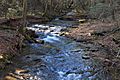
Arnold Creek looking upstream
|
|
| Physical characteristics | |
| Main source | valley a short distance from the edge of the Bowman Creek watershed in Ross Township, Luzerne County, Pennsylvania 1,960 ft (600 m) |
| River mouth | Huntington Creek in Ross Township, Luzerne County, Pennsylvania 935 ft (285 m) 41°16′43″N 76°11′31″W / 41.27861°N 76.19189°W |
| Length | 5.2 mi (8.4 km) |
| Basin features | |
| Progression | Huntington Creek → Fishing Creek → Susquehanna River → Chesapeake Bay |
| Basin size | 4.72 sq mi (12.2 km2) |
| Tributaries |
|
Arnold Creek is a cool stream in Luzerne County, Pennsylvania. It flows into Huntington Creek. This creek is about 5.2 miles (8.4 km) long. It runs through a place called Ross Township.
The area that drains into Arnold Creek is about 4.72 square miles (12.2 km2). The creek has three small streams that flow into it, but they don't have names. Arnold Creek is special because it's known for its wild trout. These fish, called brook trout, live and reproduce naturally here. You can also find beech trees growing along its banks.
Contents
Where Does Arnold Creek Flow?

Arnold Creek starts in a deep valley in Ross Township. It's not far from another stream called Bowman Creek. The creek first flows towards the south-southwest. Then it turns and flows south-southeast for a bit.
As it continues, a small, unnamed stream joins it from the left side. The valley around the creek gets deeper. Two more unnamed streams then join Arnold Creek. One comes from the left, and another from the right.
Later, the valley becomes less deep. The creek turns south-southwest and then south. It crosses Pennsylvania Route 118 near a community called Kyttle. After crossing the road, the creek flows south-southwest again. It makes a turn and then flows south-southeast for about 1.5 miles (2.4 km). The valley gets deep once more. Finally, Arnold Creek leaves its valley and meets up with Huntington Creek.
Arnold Creek joins Huntington Creek about 21.18 miles (34.09 km) upstream from where Huntington Creek ends.
What Are Arnold Creek's Tributaries?
Arnold Creek doesn't have any named streams flowing into it. However, it does have three smaller, unnamed streams that join it along its path.
Water and Land Around the Creek
The water in Arnold Creek has a certain level of alkalinity. This means how much it can balance acids. Upstream from Pennsylvania Route 118, the alkalinity is 4 milligrams per liter. Downstream from the road, it goes up slightly to 5 milligrams per liter.
The lowest point of Arnold Creek, where it meets Huntington Creek, is about 935 feet (285 meters) above sea level. The highest point, where the creek starts, is about 1960 feet (597 meters) above sea level.
Pennsylvania Route 118 crosses Arnold Creek about 2.7 miles (4.3 km) upstream from its mouth. The end of the creek is just north of a place called Harveyville.
How Big is the Creek's Watershed?
The watershed of Arnold Creek covers an area of 4.72 square miles (12.2 km2). A watershed is all the land where water drains into a particular stream or river.
Arnold Creek is entirely located within the Sweet Valley area, as mapped by the United States Geological Survey. Some parts of the creek are open for people to visit. Upstream from Pennsylvania Route 118, about 63 percent of the creek is open to the public. The other 37 percent is private land. Downstream from the road, 59 percent is open to the public, and 41 percent is private.
A part of Arnold Creek also flows through Pennsylvania State Game Lands Number 206. These are areas set aside for wildlife and public recreation.
History of Arnold Creek
Arnold Creek was officially added to the Geographic Names Information System on August 2, 1979. This system keeps track of names for places and features in the United States.
A special bridge was built over Arnold Creek in 1957. It's called a prestressed box beam bridge and is about 24.9 feet (7.6 meters) long. This bridge carries T-547 and Patla Road. Another bridge carries Pennsylvania Route 118 over the creek. In 1996, there were plans to fix up this bridge, which was estimated to cost $3,000.
In 1999, the entire length of Arnold Creek was given a special status. It was named "Class A Wild Trout Waters." This means it's a great place for wild trout to live and thrive.
Wildlife in Arnold Creek
The Pennsylvania Fish and Boat Commission considers two parts of Arnold Creek to be "Class A Wild Trout Waters." This is a very important designation for fishing and conservation.
One section of the creek, about 2.3 miles (3.7 km) long, runs from where the creek starts down to Pennsylvania Route 118. The second section, about 2.7 miles (4.3 km) long, goes from Pennsylvania Route 118 to where the creek joins Huntington Creek. Both of these sections are excellent habitats for brook trout. These trout are special because they reproduce naturally in the creek.
Arnold Creek is one of six streams that flow directly into Huntington Creek and are designated as Class A Wild Trout Waters. The other streams are Mitchler Run, Shingle Run, Lick Branch, Phillips Creek, and part of Kitchen Creek.
Besides trout, you can also find young beech trees growing along the banks of Arnold Creek.
Images for kids
-
Arnold Creek looking upstream
-
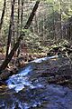
Arnold Creek looking downstream
