Ascutney Mill Dam facts for kids
Quick facts for kids Windsor Upper Dam |
|
|---|---|

Windsor Upper Dam
|
|
| Location | Windsor, Vermont |
| Coordinates | 43°28′36″N 72°23′46″W / 43.47667°N 72.39611°W |
| Construction began | June 1834 |
| Opening date | November 1834 |
| Operator(s) | Ascutney Mill Dam Company |
| Dam and spillways | |
| Impounds | Mill Brook |
| Height | 40 ft (12 m) |
| Length | 250 ft (76 m) |
| Width (base) | 36 ft (11 m) |
|
Ascutney Mill Dam Historic District
|
|
| Lua error in Module:Location_map at line 420: attempt to index field 'wikibase' (a nil value). | |
| Location | 55 and 57 Ascutney St., Windsor, Vermont |
| Area | 4.8 acres (1.9 ha) |
| Built | 1783 |
| Architect | Simeon Cobb |
| Architectural style | Federal-Greek Revival |
| NRHP reference No. | 06001236 |
| Added to NRHP | January 9, 2007 |
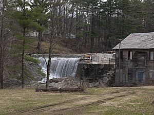
The Ascutney Mill Dam, also known as the Windsor Upper Dam or the Mill Pond Dam, is a very old and important dam in the United States. It is an arch-gravity dam, which means it uses both its curved shape and its heavy weight to hold back water. This dam is made of strong, cut granite stone.
You can find it in Windsor, Vermont, in Windsor County, close to the Connecticut River. For many years, it helped power nearby mills. First, it provided hydropower (power from moving water), and later, it helped make hydroelectric power (electricity from water).
Because of its historical importance, the dam has been recognized in a few ways. It has been on the ASCE list of historic civil engineering landmarks since 1970. It is also listed on the National Register of Historic Places as the Ascutney Mill Dam Historic District since January 9, 2007.
Contents
What is the Windsor Upper Dam?
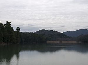
The Windsor Upper Dam was built in the valley of the Mill Brook. This brook is a small river that flows into the Connecticut River. The water held back by the dam forms a pond called the Mill Pond.
The main goal of the dam was to control the water flow. This was important for local businesses like sawmills and gristmills. These mills used water power to operate. Before the dam, they often had to stop working when the Mill Brook's water level was too low. The dam allowed water to be stored, especially in winter, and then released when needed during drier seasons.
Building the Dam
The Ascutney Mill Dam Company was created in 1833 to build this important structure. Construction started in June 1834 and was finished by November of the same year. This was a very quick build, taking only about seven months!
Ithamar A. Beard, an engineer from New England, surveyed the area and chose the best spot for the dam. Simeon Cobb and Joseph Mason were the contractors who managed the building work. Allen Wardner, a well-known businessman from Windsor, oversaw the project.
The first step was to remove a smaller dam that was already there. Then, in June, the first large granite blocks were put into place. This granite came from quarries nearby. The finished dam was about 40 ft (12 m) high and 76.25 ft (23.24 m) long. It was one of the first arch-gravity dams in the U.S. and might be the oldest large masonry dam (a dam built from stone or brick) in the country.
Early Challenges
When the dam was first built, water would fill up behind it in winter. In spring, the water and ice would flow over the top and fall 40 feet (12 m) to the rocks below. This created a lot of noise and vibrations that worried the people living nearby. Even though inspections showed the dam was safe, a stone support was built below it to help stop the vibrations.
How the Dam Works Today
The Windsor Upper Dam is still in good shape, even though it's one of the oldest dams in the United States. In the 20th century, a concrete layer was added to the top of the dam. This helps make sure it stays strong during floods.
Dams like this are sometimes inspected to make sure they are safe. In 1978, an inspection found the dam to be in "fair condition" and safe for normal use. Today, only dams that can hold back more than 500,000 cubic feet (14,000 m3) of water need to be inspected in Vermont. The Windsor Upper Dam is smaller than that, so it doesn't require regular state inspections.
Understanding the Area
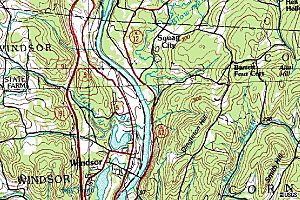
A United States Geological Survey (USGS) map of the Windsor area shows that it has many mountains. In fact, Windsor County, Vermont, has over 200 mountain peaks!
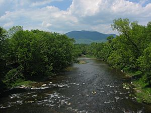
In areas with uneven terrain like this, the amount of water flowing in rivers can change a lot. When it rains heavily, water flows quickly down the mountains into the rivers. This can cause river levels to rise very fast. Because the Connecticut River is also nearby, controlling the dam's gates to manage water flow was very important for making hydroelectric power.
Nearby Places
| Nearby Cities and Towns | Distance |
|---|---|
| Windsor, VT | <.1 mile |
| Cornish Mills, NH | 1.4 miles (2.3 km) ESE |
| Cornish City, NH | 2.4 miles (3.9 km) ESE |
| Squag City, NH | 3.1 miles (5.0 km) NNE |
| Balloch, NH | 3.1 miles (5.0 km) S |
| Cornish Center, NH | 3.9 miles (6.3 km) E |
| Brownsville, VT | 3.9 miles (6.3 km) W |
| Hartland, VT | 4.3 miles (6.9 km) N |
| Plainfield, NH | 4.5 miles (7.2 km) NNE |
| South Cornish, NH | 4.7 miles (7.6 km) ESE |
Fishing
The area around the Windsor Upper Dam is a popular spot for fishing. People enjoy both fly fishing and using bait. You can find fish like bluegill, brook trout, and rock bass here. The area is open to the public, but remember, you'll need a Vermont fishing license to cast your line!
See Also
- List of historic civil engineering landmarks
 | William Lucy |
 | Charles Hayes |
 | Cleveland Robinson |


