
Aterno-Pescara facts for kids
Quick facts for kids Aterno-Pescara |
|
| River | |
 The Aterno-Pescara river.
|
|
| Country | Italy |
|---|---|
| State | Southern Italy |
| Region | Abruzzo |
| Provinces | L'Aquila, Pescara, Chieti |
| Tributaries | |
| - left | Tirino |
| - right | Raio, Sagittario, Pescara, Orta |
| Cities | L'Aquila, Chieti, Pescara |
| Source | Monti della Laga |
| - location | Montereale, Abruzzo, Italy |
| - elevation | 1,013 m (3,323 ft) |
| - coordinates | 42°09′53.17″N 13°49′18.29″E / 42.1647694°N 13.8217472°E |
| Mouth | Adriatic Sea |
| - location | Pescara, Abruzzo, Italy |
| - elevation | 0 m (0 ft) |
| - coordinates | 42°28′10.87″N 14°13′46.62″E / 42.4696861°N 14.2296167°E |
| Length | 145 km (90 mi) |
| Basin | 3,188 km² (1,231 sq mi) |
| Discharge | for Pescara |
| - average | 57 m³/s (2,013 cu ft/s) |
The Aterno-Pescara is the longest river in the Abruzzo region of Italy. It also has the largest watershed (the area of land where all water drains into the river) among rivers flowing into the Adriatic Sea south of the Reno river. Its watershed covers about 3,190 square kilometers (1,230 square miles).
The river starts high up in the Monti della Laga mountains. It is first called the Aterno river. It flows mostly through the L'Aquila and Pescara provinces. It also passes through the Chieti province for a short distance. Near the town of Popoli, another river called the Pescara joins it. From that point, the river is known as the Aterno-Pescara. It then flows into the Adriatic Sea at the city of Pescara.
Contents
River Facts
The Aterno-Pescara river is about 145 kilometers (90 miles) long. Its drainage basin covers an area of about 3,188 square kilometers (1,231 square miles).
This river can be thought of in three main parts:
- The Aterno part, from where it starts until it meets the Sagittario river.
- The Aterno-Sagittario part, from that meeting point until it joins the Pescara river.
- The Aterno-Pescara part, from there until it reaches the Adriatic Sea.
Where the Aterno Begins
The Aterno river starts in the Monti della Laga mountain range. It begins at an altitude of 1,013 meters (3,323 feet) above sea level. This starting point is just northeast of Aringo, a small village in the Montereale area. The river flows through the Montereale canyon and generally moves towards the southeast. It passes south of the city of L'Aquila.
After passing through the San Venanzio canyon and the town of Raiano, the Aterno river turns and flows towards the northeast.
Joining the Sagittario
In the town of Popoli, the Aterno river meets its most important tributary (a smaller river that flows into a larger one), which is called the Sagittario. For many kilometers after this, the river is known as the Aterno-Sagittario.
Becoming the Aterno-Pescara
Later on, the Aterno-Sagittario river is joined by the Pescara river. This Pescara river is quite short. From this meeting point, the main river is called the Aterno-Pescara, or sometimes just the Pescara. It continues to flow towards the northeast.
The river then travels through the valley of Pescara. It passes near the lower part of the city of Chieti. Finally, it reaches the city of Pescara, where it flows into the Adriatic Sea.
Cities and Towns Along the River
The Aterno-Pescara river flows through many municipalities (towns and cities). Some of these include:
- Province of L'Aquila
- Montereale
- Cagnano Amiterno
- Barete
- Pizzoli
- L'Aquila
- San Demetrio ne' Vestini
- Raiano
- Province of Pescara
- Popoli
- Bussi sul Tirino
- Castiglione a Casauria
- Pescara
- Province of Chieti
Main Rivers Joining the Aterno-Pescara
Many smaller rivers, called tributaries, flow into the Aterno-Pescara river. Here are some of the main ones:
|
Rivers joining from the left:
|
Rivers joining from the right:
|
Images for kids
-

The San Venanzio canyon.
-
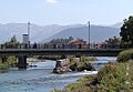
A bridge over the Aterno in Popoli.
-
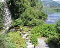
The source of the Pescara river.
-
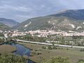
A view of a spring of the Pescara river, with Popoli in the background.
-
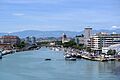
The mouth of the Pescara river where it meets the sea.
.jpg)


Related pages
See also
 In Spanish: Aterno-Pescara para niños
