AuSable, New York facts for kids
Quick facts for kids
Au Sable, New York
|
|
|---|---|

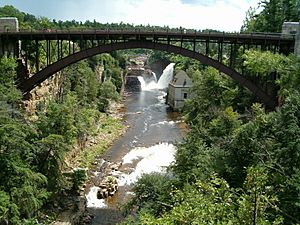
The AuSable Chasm Bridge
|
|

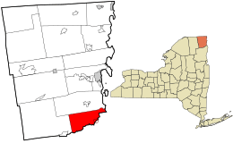
Location in Clinton County and the state of New York.
|
|
| Country | United States |
| State | New York |
| County | Clinton |
| Government | |
| • Type | Town Council |
| Area | |
| • Total | 43.85 sq mi (113.58 km2) |
| • Land | 39.11 sq mi (101.30 km2) |
| • Water | 4.74 sq mi (12.28 km2) |
| Elevation | 778 ft (237 m) |
| Population
(2010)
|
|
| • Total | 3,146 |
| • Estimate
(2016)
|
3,082 |
| • Density | 78.80/sq mi (30.42/km2) |
| Time zone | UTC-5 (Eastern (EST)) |
| • Summer (DST) | UTC-4 (EDT) |
| FIPS code | 36-019-03221 |
| GNIS feature ID | 0978699 |
Au Sable, also called Ausable, is a town in Clinton County, New York, in the United States. In 2010, about 3,146 people lived there. The town gets its name from the Ausable River, which flows through it. The name "Au Sable" means "of sand."
The town is located in the southeastern part of Clinton County. It is south of the city of Plattsburgh.
Contents
History of Au Sable
The area that is now Au Sable was first settled around 1795. Most of the early settlers were of English background. The town itself was officially formed in 1839. It was created from a part of the nearby town of Peru.
A famous landmark, the AuSable Chasm Bridge, was built in Au Sable between 1932 and 1933.
Geography and Nature
Au Sable covers a total area of about 43.85 square miles (113.6 square kilometers). Most of this area is land, about 39.11 square miles (101.3 square kilometers). The rest, about 4.74 square miles (12.3 square kilometers), is water.
Water Features
The town is next to Lake Champlain on its eastern side. The southern border of Au Sable is also the border of Essex County.
A very popular place for tourists is Ausable Chasm. This is a deep gorge carved by the Ausable River. It is located along the southeastern edge of the town.
Roads and Transportation
Several important roads pass through Au Sable. Interstate 87, also known as the Adirondack Northway, is a major highway that runs north and south. You can get to Au Sable from Exit 34 (Route 9N) on this highway.
U.S. Route 9 runs closer to Lake Champlain. New York State Route 9N goes east and west along the southern town line. It connects with US 9 in Keeseville. New York State Route 22 is another north-south highway, mostly located west of the Northway.
Population Information
| Historical population | |||
|---|---|---|---|
| Census | Pop. | %± | |
| 1840 | 3,222 | — | |
| 1850 | 4,492 | 39.4% | |
| 1860 | 3,227 | −28.2% | |
| 1870 | 2,863 | −11.3% | |
| 1880 | 2,980 | 4.1% | |
| 1890 | 2,532 | −15.0% | |
| 1900 | 2,195 | −13.3% | |
| 1910 | 2,045 | −6.8% | |
| 1920 | 1,636 | −20.0% | |
| 1930 | 1,868 | 14.2% | |
| 1940 | 1,985 | 6.3% | |
| 1950 | 1,903 | −4.1% | |
| 1960 | 2,605 | 36.9% | |
| 1970 | 2,652 | 1.8% | |
| 1980 | 2,792 | 5.3% | |
| 1990 | 2,870 | 2.8% | |
| 2000 | 3,015 | 5.1% | |
| 2010 | 3,146 | 4.3% | |
| 2016 (est.) | 3,082 | −2.0% | |
| U.S. Decennial Census | |||
In 2000, there were 3,015 people living in Au Sable. There were 1,180 households, which are groups of people living together. About 831 of these were families. The population density was about 77 people per square mile.
About 33% of the households had children under 18 living with them. Many households, about 54%, were married couples. About 24% of all households were made up of people living alone.
The average age of people in the town was 38 years old. About 26% of the population was under 18 years old.
Communities and Places in Au Sable
- Au Sable Beach – This is a spot on the shore of Lake Champlain. It is located where the Au Sable River meets the lake.
- Ausable Chasm – This is a deep gorge created by the Au Sable River. It is a popular place for tourists to visit. There is also a small community (hamlet) nearby with the same name.
- Au Sable River – This river flows along the town's border and into Lake Champlain.
- Birmingham Falls – A historic place located near Keeseville.
- Clintonville – A small community (hamlet) near the southern town line. It is on New York State Route 9N. This community used to be a village but later changed its status.
- Harkness – A hamlet located near the northern border of the town.
- Keese Corners – A place near the northern town line.
- Keeseville – This used to be a village on U.S. Route 9. It is located at the southern town line and extends into the town of Chesterfield in Essex County.
- New Sweden – A historic location within the town.
- Rogers – A hamlet in the southwestern part of the town, located on New York State Route 9N.
- Thomasville – A place in the southwestern part of the town.
- Union – A historic location at the northern town line.
See also
 In Spanish: Au Sable (Nueva York) para niños

