
Avila Beach, California facts for kids
Quick facts for kids
Avila Beach, California
|
|
|---|---|

Avila Beach, with Point San Luis at left
|
|

Location of Avila Beach in San Luis Obispo County, California.
|
|

Avila Beach, California
Location in California

Avila Beach, California
Location in the United States
|
|
| Country | |
| State | |
| County | San Luis Obispo |
| Area | |
| • Total | 6.31 sq mi (16.34 km2) |
| • Land | 6.09 sq mi (15.77 km2) |
| • Water | 0.22 sq mi (0.58 km2) 0.29% |
| Elevation | 430 ft (130 m) |
| Population
(2020)
|
|
| • Total | 1,576 |
| • Density | 258.91/sq mi (99.96/km2) |
| Time zone | UTC-8 (Pacific (PST)) |
| • Summer (DST) | UTC-7 (PDT) |
| ZIP codes |
93424
|
| Area code(s) | 805 |
| FIPS code | 06-03330 |
| GNIS feature ID | 2582937 |


Avila Beach (which means Ávila in Spanish) is a small town in San Luis Obispo County, California, USA. It sits right on San Luis Obispo Bay. It's about 160 miles (257 km) northwest of Los Angeles and 200 miles (322 km) south of San Francisco. In 2010, about 1,576 people lived here. It's known as a "census-designated place" (CDP) for counting people.
Contents
History of Avila Beach
How Avila Beach Got Its Name
The town of Avila Beach is named after Miguel Ávila. He was given a large piece of land called Rancho San Miguelito in 1842. The town itself started in the late 1800s.
Early Days and Growth
Avila Beach was once the main shipping port for San Luis Obispo. Around that time, a hotel was built here for honeymoons. Steamboats brought many visitors from San Francisco and Los Angeles.
Avila Beach Today
Today, Avila Beach still has a working pier for commercial fishing. There are also many apple orchards nearby. However, tourism is now the most important industry. Not many old buildings are left. One of the oldest is the Point San Luis Lighthouse, built in 1890 after many ship accidents.
Cleaning Up the Town
In the late 1990s, a company called Unocal cleaned up oil that had leaked from old pipes under the town. This oil had caused a big spill. Over 6,750 truckloads of dirty soil were removed. Clean sand from the Guadalupe Dunes replaced it. Many homes and businesses had to be taken down for this cleanup. New buildings, walkways, and benches have since been built.
Exploring Avila Beach's Geography
Where is Avila Beach Located?
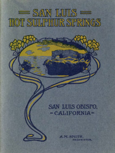
The main part of Avila Beach is just a few blocks near the beach. You can find restaurants, bars, and shops along Front Street. Homes, hotels, and small businesses are also close by. There are some fancy housing areas inland near a golf course. Avila Beach is also famous for its hot springs, which are used at resort spas.
San Luis Obispo Creek
The San Luis Obispo Creek flows into the ocean just west of downtown. This creek collects water from much of the San Luis Obispo area. It's not recommended for swimming because of some farm runoff.
What is the Size of Avila Beach?
Avila Beach covers about 6.0 square miles (15.6 km²). Most of this area is land (99.71%), and a small part is water (0.29%).
Beaches to Visit
Avila Beach has a main beach that is less than 0.5 miles (0.8 km) long. It is protected in San Luis Bay by land on both sides. This means it is usually warmer than other beaches on the Central Coast.
- Olde Port Beach: This beach is west of the Cal Poly SLO pier. It is a good place to bring your dog. It's not as good for water sports as the main town beach.
- Fisherman's Beach: This is a small beach closest to the port.
Fun Trails to Explore
The Avila Beach area has three well-known trails for walking or biking.
- The Bob Jones Trail: This trail connects the Avila Beach Golf Resort to Highway 101. It is three miles long and follows an old railroad path. It will eventually connect to San Luis Obispo.
- The Shell Beach Bluff Trail: This trail starts near Cave Landing Road. It leads to Smuggler's Cave and Pirate's Cove Beach. You can get a great view of the town by looking through Smuggler's Cave.
- The Pecho Coast Trail: This trail goes from Port San Luis to the Point San Luis Lighthouse. You need a guide to hike this trail.
Avila Beach Weather
The weather in Avila Beach doesn't change much throughout the year. Temperatures range from 47-49°F (8-9°C) to 70-72°F (21-22°C) from November to April. From May to October, temperatures are usually between 60-69°F (16-21°C) and 80-82°F (27-28°C). The area gets about 15 inches (38 cm) of rain each year. Most of the rain falls in winter, from December to March. Summers are usually very dry.
People of Avila Beach
Who Lives in Avila Beach?
The 2010 United States census counted 1,627 people living in Avila Beach. Most of the people (92.6%) were White. About 6.8% of the people were of Hispanic or Latino background.
Households and Families
There were 842 households in Avila Beach. About 13.7% of these households had children under 18. Many households (49.4%) were married couples. The average household had about 1.93 people.
Age Groups
The population of Avila Beach includes people of all ages. About 11.2% of the people were under 18 years old. A large portion, 31.3%, were 65 years or older. The average age in Avila Beach was 56.9 years.
Economy and Attractions
Piers in Avila Beach
Avila Beach and nearby Port San Luis have three piers.
- Avila Beach Pier: This pier is the farthest east and is 1,685 feet (514 m) long. It has been closed since 2015 due to safety concerns.
- Cal Poly SLO Pier: This is the middle pier. It belongs to California Polytechnic State University (Cal Poly SLO) and is used for marine research. It is not open to the public.
- Harford Pier: This is the westernmost pier. It has been used by commercial fishing boats since 1873 to unload their catch.
Whale Watching
The Harford Pier is a great spot for whale watching. Many gray and humpback whales come into the bay near the pier to feed. This brings many visitors during whale season.
Diablo Canyon Power Plant
The Diablo Canyon Power Plant is located about 6 miles (10 km) northwest of Avila Beach. It is the last working nuclear power plant in California. The road to the plant is near the Harford Pier.
Gallery
-
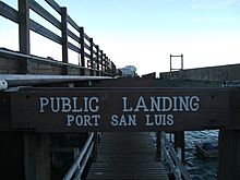
Port San Luis Pier. The pier also has a live fish market and harbor patrol office.
-
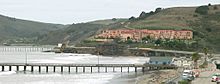
Avila Beach and its piers.
-
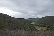
See Canyon in Avila Beach, with apple orchards visible in the distance.
-
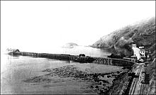
Avila Beach and Harford Pier, late 19th century. Point San Luis and Whaler's Island are visible in the near distance.
-
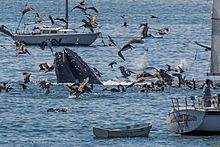
Humpback whale lunge feeding off Avila Beach, 2012
-
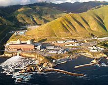
Diablo Canyon Power Plant


See also
 In Spanish: Avila Beach para niños
