Avocado Heights, California facts for kids
Quick facts for kids
Avocado Heights, California
|
|
|---|---|

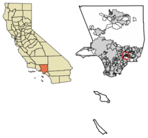
Location of Avocado Heights in Los Angeles County, California
|
|
| Country | |
| State | |
| County | |
| Area | |
| • Total | 2.25 sq mi (5.84 km2) |
| • Land | 2.25 sq mi (5.83 km2) |
| • Water | 0.00 sq mi (0.01 km2) 4.77% |
| Elevation | 338 ft (103 m) |
| Population
(2020)
|
|
| • Total | 13,317 |
| • Density | 5,916.04/sq mi (2,284.54/km2) |
| Time zone | UTC-8 (PST) |
| • Summer (DST) | UTC-7 (PDT) |
| ZIP code |
91746
|
| Area code(s) | 626 |
| FIPS code | 06-03344 |
| GNIS feature ID | 1724314 |
Avocado Heights () is a special community in Los Angeles County, California, United States. It's not a city, but a "census-designated place" (CDP). This means it's a defined area used for gathering population data. It is mostly surrounded by the City of Industry.
Avocado Heights is close to major highways like the Pomona (SR-60) and San Gabriel (I-605) freeways. The San Gabriel River is to its west. This community is about 15 miles (24 km) from downtown Los Angeles. In 2020, about 13,317 people lived here.
A large part of Avocado Heights still feels like the countryside, with many homes on big pieces of land. Because of nearby factories and a landfill, property values stayed lower for a long time. This meant the area didn't develop as much as other parts of the San Gabriel Valley.
Contents
Geography of Avocado Heights

Avocado Heights is located at 34°2′19″N 118°0′16″W / 34.03861°N 118.00444°W. This is about 1.7 miles (2.7 km) southeast of El Monte. The area covers about 2.8 square miles (7.3 square kilometers). Most of this area is land, with a small amount of water.
The main road in Avocado Heights is Don Julian Road. It is named after William Workman, an early settler. His home was just to the east in Industry. The community has a school called Don Julian Elementary School. It is part of the Bassett Unified School District.
Culture and Community Life
Avocado Heights is well-known for its private ranches. Many people enjoy horse riding here.
For many years, from the 1920s to the early 2000s, a tall, single white tower stood on 3rd Avenue and Starlight Lane. More recently, in the 2010s, a skatepark was built in Avocado Heights, giving young people a place to skate.
Climate in Avocado Heights
Avocado Heights has a "Hot Summer Mediterranean climate." This means it has warm winters and very hot summers. Nearby hills to the south help keep the area warmer than other cities nearby.
| Climate data for Avocado Heights, California (1981–2010 normals) | |||||||||||||
|---|---|---|---|---|---|---|---|---|---|---|---|---|---|
| Month | Jan | Feb | Mar | Apr | May | Jun | Jul | Aug | Sep | Oct | Nov | Dec | Year |
| Mean daily maximum °F (°C) | 72 (22) |
73 (23) |
76 (24) |
80 (27) |
84 (29) |
90 (32) |
95 (35) |
96 (36) |
95 (35) |
85 (29) |
79 (26) |
72 (22) |
83 (28) |
| Mean daily minimum °F (°C) | 49 (9) |
50 (10) |
52 (11) |
54 (12) |
59 (15) |
63 (17) |
65 (18) |
67 (19) |
65 (18) |
60 (16) |
53 (12) |
49 (9) |
57 (14) |
| Average precipitation inches (mm) | 3.78 (96) |
3.53 (90) |
2.66 (68) |
.93 (24) |
.33 (8.4) |
.06 (1.5) |
.01 (0.25) |
.03 (0.76) |
.18 (4.6) |
.30 (7.6) |
1.21 (31) |
2.43 (62) |
16.43 (417) |
Population and Demographics
| Historical population | |||
|---|---|---|---|
| Census | Pop. | %± | |
| 1970 | 9,810 | — | |
| 1980 | 11,721 | 19.5% | |
| 1990 | 14,232 | 21.4% | |
| 2000 | 15,148 | 6.4% | |
| 2010 | 15,411 | 1.7% | |
| 2020 | 13,317 | −13.6% | |
| U.S. Decennial Census 1850–1870 1880-1890 1900 1910 1920 1930 1940 1950 1960 1970 1980 1990 2000 2010 |
|||
Population in 2010
The 2010 United States census showed that Avocado Heights had 15,411 people. The population density was about 5,424 people per square mile (2,094 people per square kilometer).
The community is very diverse. Many people identified as Hispanic or Latino. There were also many White, Asian, African American, and Native American residents.
About 27% of the population was under 18 years old. The average age was 33.7 years. Most people lived in family homes. The average household had about 4 people.
Population in 2000
In the 2000 United States census, the population was 15,148. The population density was about 5,676 people per square mile (2,192 people per square kilometer).
Like in 2010, the community was very diverse. About 77% of the population identified as Hispanic or Latino.
The average income for a household in Avocado Heights was about $48,712. About 16% of the population lived below the poverty line.
Education in Avocado Heights
Students in the northern part of Avocado Heights go to Don Julian Elementary School. This school is part of the Bassett Unified School District. They then go to Bassett High School.
Students in the southern part of Avocado Heights attend Wallen Andrews Elementary School. This school is in the Whittier City School District. They then go to Pioneer High School, which is part of the Whittier Union High School District.
See also
 In Spanish: Avocado Heights para niños
 | Tommie Smith |
 | Simone Manuel |
 | Shani Davis |
 | Simone Biles |
 | Alice Coachman |


