Axis, Alabama facts for kids
Quick facts for kids
Axis, Alabama
|
|
|---|---|

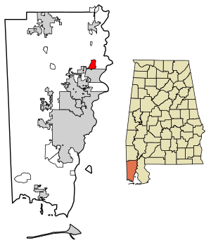
Location in Mobile County, Alabama
|
|
| Country | United States |
| State | Alabama |
| County | Mobile |
| Area | |
| • Total | 3.50 sq mi (9.08 km2) |
| • Land | 3.50 sq mi (9.05 km2) |
| • Water | 0.01 sq mi (0.03 km2) |
| Elevation | 39 ft (12 m) |
| Population
(2020)
|
|
| • Total | 561 |
| • Density | 160.52/sq mi (61.98/km2) |
| Time zone | UTC-6 (Central (CST)) |
| • Summer (DST) | UTC-5 (CDT) |
| ZIP code |
36505
|
| Area code(s) | 251 |
| FIPS code | 01-03508 |

Axis is a small community in Mobile County, Alabama, United States. It is known as an "unincorporated community" and a "census-designated place" (CDP). This means it's a recognized area by the government for counting people, but it doesn't have its own city government.
In 2020, about 561 people lived in Axis. This was a decrease from 757 people in 2010. The community has its own post office with the ZIP code 36505. A special place called the Kirk House in Axis is listed on the Alabama Register of Landmarks and Heritage.
Contents
People Living in Axis
| Historical population | |||
|---|---|---|---|
| Census | Pop. | %± | |
| 2020 | 561 | — | |
| U.S. Decennial Census | |||
In 2010, Axis had a population of 757 people. Most of the people living there were white (66.8%). About 26.9% were Black or African American. Other groups included Native American (3.2%), Asian (0.1%), and Pacific Islander (0.1%). About 2.6% of people were from two or more races. A small number, 0.9%, were Hispanic or Latino.
Where is Axis Located?
Axis is in the northeastern part of Mobile County. It sits at coordinates 30°55′48″N 88°01′38″W / 30.92990°N 88.02722°W and is about 39 feet (12 meters) above sea level. The city of Creola is just south of Axis.
U.S. Route 43 is a main road that goes through the western side of Axis. This road goes south about 17 miles (27 km) to downtown Mobile. It also goes north about 11 miles (18 km) to Mount Vernon.
The Axis census-designated place covers an area of about 3.5 square miles (9.1 square kilometers). Only a very small part of this area, about 0.01 square miles (0.03 square kilometers), is water.
Schools in the Axis Area
Public schools in Axis are part of the Mobile County Public School System. Students in Axis usually attend North Mobile County K-8 School. This school used to be called North Mobile County Middle School. After K-8, students go to Citronelle High School in Citronelle.
North Mobile County Middle School opened in 2010. It took over from Adams Middle School in Saraland. This change happened because students outside of Saraland were no longer assigned to Adams Middle. The new school was built on a "16th section" of land. This is a special piece of land set aside for schools by an Alabama law.
Before the city of Satsuma created its own school system, students from Axis went to Satsuma High School. After Satsuma separated, there were discussions about which high schools Axis students would attend.
The Viscose Plant in Axis
A company called Courtaulds used to make a material called viscose rayon at a plant near Axis. This plant started operating around 1952. The process of making viscose rayon released a chemical called carbon disulfide (CS2) into the air.
In 1991, government agencies found that the Axis plant released more carbon disulfide than all nine other plants in Alabama that also released this chemical. New laws, like the United States' Clean Air Act in 1990, required factories to reduce their pollution.
The plant tried to improve its process. Between 1993 and 1997, the factory was updated. These changes helped them reuse about 50-55% of the carbon disulfide. This meant less of it was released into the air. However, the company did not use a special technology that could have reduced emissions by 90%. This technology had been used in their European factories for many years.
See also
 In Spanish: Axis (Alabama) para niños
 | Emma Amos |
 | Edward Mitchell Bannister |
 | Larry D. Alexander |
 | Ernie Barnes |


