Citronelle, Alabama facts for kids
Quick facts for kids
Citronelle, Alabama
|
|||
|---|---|---|---|
|
|||
| Nickname(s):
"The Best Kept Secret in Southern Alabama"
|
|||

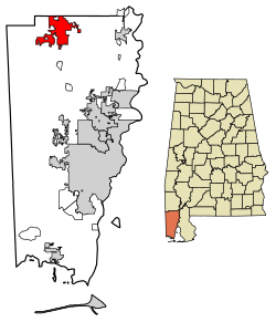
Location in Mobile County, Alabama
|
|||
| Country | United States | ||
| State | Alabama | ||
| County | Mobile | ||
| Area | |||
| • Total | 26.12 sq mi (67.65 km2) | ||
| • Land | 25.84 sq mi (66.94 km2) | ||
| • Water | 0.28 sq mi (0.71 km2) | ||
| Elevation | 312 ft (95 m) | ||
| Population
(2020)
|
|||
| • Total | 3,946 | ||
| • Density | 152.68/sq mi (58.95/km2) | ||
| Time zone | UTC-6 (Central (CST)) | ||
| • Summer (DST) | UTC-5 (CDT) | ||
| ZIP code |
36522
|
||
| Area code(s) | 251 | ||
| FIPS code | 01-15064 | ||
| GNIS feature ID | 0116155 | ||
Citronelle is a city in Mobile County, Alabama, United States. It's located near the northern border of the county. In 2020, about 3,946 people lived there. Citronelle is part of the larger Mobile area and is about 34 miles (55 km) north of the city of Mobile.
Contents
History of Citronelle
Early Inhabitants and European Settlers
For thousands of years, different groups of Native Americans lived in the Citronelle area. When Europeans first arrived, the Choctaw and Creek tribes often hunted here.
French explorers were the first Europeans to visit this area in the 1700s. They discovered that the land had special healing herbs and natural springs. People started settling in Citronelle in 1811, and it officially became a town in 1892. The name "Citronelle" comes from a French word for the citronella plant.
A Popular Resort Town
In the late 1800s, Citronelle became a very popular place for people to visit. They came for the nice weather, the healing herbs, and the special spring water. Many hotels were built to welcome all the visitors who wanted to relax and feel better.
The End of the Civil War
A very important event happened in Citronelle on May 4, 1865. One of the last major Confederate armies surrendered here. Lieutenant General Richard Taylor gave up his army under a large tree, which became known as the "Surrender Oak." This was a big step in ending the American Civil War.
This surrender was the third of five main surrenders that finished the war. The first two happened in Virginia and North Carolina. Today, people in Citronelle sometimes hold a special event to act out this historic surrender. Sadly, the original "Surrender Oak" tree was destroyed by a hurricane in 1902.
Oil Discovery in Alabama
In 1955, something new and exciting was found in Citronelle: oil! Because of this discovery, Citronelle is now known as the "oil capital" of Alabama.
Citronelle's Unique Geology
Citronelle sits on something called the Citronelle Dome. Imagine a giant underground bubble of salt that is slowly pushing upwards. This dome is why the streams around Citronelle flow away from the center, like spokes on a wheel.
In 1955, oil was found deep inside this dome. This was a big deal because it showed that oil could be found much deeper than people thought. The Citronelle Dome became one of the first "deep" oil fields. This oil field has produced a lot of oil over the years.
Geography of Citronelle
Citronelle is located in the northern part of Mobile County. The city's northern edge touches the border of Washington County. U.S. Route 45 is a main road that goes through the city from north to south.
If you drive on US 45, downtown Mobile is about 34 miles (55 km) to the south. The city of Citronelle covers a total area of about 26.1 square miles (67.6 square kilometers). Most of this area is land, with a small part being water.
Population of Citronelle
| Historical population | |||
|---|---|---|---|
| Census | Pop. | %± | |
| 1850 | 250 | — | |
| 1880 | 169 | — | |
| 1900 | 696 | — | |
| 1910 | 935 | 34.3% | |
| 1920 | 932 | −0.3% | |
| 1930 | 1,082 | 16.1% | |
| 1940 | 1,057 | −2.3% | |
| 1950 | 1,350 | 27.7% | |
| 1960 | 1,918 | 42.1% | |
| 1970 | 1,935 | 0.9% | |
| 1980 | 2,841 | 46.8% | |
| 1990 | 3,671 | 29.2% | |
| 2000 | 3,659 | −0.3% | |
| 2010 | 3,905 | 6.7% | |
| 2020 | 3,946 | 1.0% | |
| U.S. Decennial Census 2013 Estimate |
|||
Citronelle's Population in 2020
In 2020, there were 3,946 people living in Citronelle. There were 1,412 households and 1,021 families in the city.
| Race | Num. | Perc. |
|---|---|---|
| White (non-Hispanic) | 2,592 | 65.69% |
| Black or African American (non-Hispanic) | 782 | 19.82% |
| Native American | 232 | 5.88% |
| Asian | 13 | 0.33% |
| Pacific Islander | 1 | 0.03% |
| Other/Mixed | 260 | 6.59% |
| Hispanic or Latino | 66 | 1.67% |
Citronelle's Population in 2010
In 2010, Citronelle had a population of 3,905 people. About 70.7% of the people were white, 20.2% were Black or African American, and 4.9% were Native American.
Education in Citronelle
The city of Citronelle is part of the Mobile County Public School System. Students in Citronelle attend these public schools:
- McDavid-Jones Elementary School (for grades K-5)
- Lott Middle School (for grades 6-8)
- Citronelle High School (for grades 9-12)
Notable People from Citronelle
- Bama Rowell: He was a professional baseball player. He played for the Boston Braves and the Philadelphia Phillies. Bama Rowell was born and grew up in Citronelle, and he lived there his whole adult life.
- Joey Dumas: He is a race car driver who won a big race at Daytona International Speedway in 2021. Joey was also born and raised in Citronelle.
See also
 In Spanish: Citronelle (Alabama) para niños
 | Valerie Thomas |
 | Frederick McKinley Jones |
 | George Edward Alcorn Jr. |
 | Thomas Mensah |


