
Bözberg facts for kids
Quick facts for kids
Bözberg
|
||
|---|---|---|

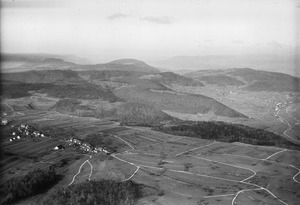
Oberbözberg village
|
||
|
||

Bözberg
Location in Switzerland

Bözberg
Location in Canton of Aargau
|
||
| Country | Switzerland | |
| Canton | Aargau | |
| District | Brugg | |
| Area | ||
| • Total | 15.5 km2 (6.0 sq mi) | |
| Elevation | 540 m (1,770 ft) | |
| Population
(Dec 2020 )
|
||
| • Total | 1,663 | |
| • Density | 107.3/km2 (277.9/sq mi) | |
| Postal code |
5224/5
|
|
| Surrounded by | Effingen, Mönthal, Remigen, Riniken | |

Bözberg is a town, also called a municipality, in the canton of Aargau in Switzerland. It is located in the Brugg district. Bözberg as we know it today was formed on January 1, 2013. This happened when four smaller towns – Gallenkirch, Linn, Oberbözberg, and Unterbözberg – decided to join together. Before this, the original Bözberg municipality had split into Oberbözberg and Unterbözberg way back in 1873.
Contents
History of Bözberg
The area of Bözberg has a long and interesting past. Different parts of what is now Bözberg have their own unique stories.
Gallenkirch's Story
Gallenkirch was first written about in 1338. Back in the Middle Ages (a long time ago!), Gallenkirch was part of a larger area controlled by the city of Bad Säckingen. People in Gallenkirch used to go to church in Hornussen. There was a small chapel in Gallenkirch dedicated to a saint named Gall. This chapel is no longer there, but parts of it were used in a building built later.
After the Protestant Reformation (a big change in religion in the 1500s), Gallenkirch became part of the Bözberg church area. For many years, from 1460 to 1798, the village was ruled by Bern, a powerful Swiss city. In more recent times, Gallenkirch tried to join with the nearby village of Linn several times, but it didn't happen until 2013. However, children from Gallenkirch have been going to school in Linn since 1917. Today, most people in Gallenkirch are farmers or travel to bigger towns for work.
Linn's Story
Linn was first mentioned around 1303. Its name might come from a very old, famous Linden tree nearby. This tree is thought to be 500 to 800 years old! In the Middle Ages, Linn was likely part of an area called Elfingen. In 1460, it became part of the Bözberg court, which was controlled by the Canton of Bern.
Before 1528, Linn had its own chapel. For a long time, farming was the main way people made a living. But in the mid-1800s, many farming families moved away because it was hard to find work. By the end of the 1900s, there were only a few farms left. Most people worked in the nearby town of Brugg. Since the 1990s, you can get to Linn by Postauto, which is like a bus service.
Oberbözberg and Unterbözberg
Both Oberbözberg and Unterbözberg were first mentioned in 1189 as "Bozeberch." For a long time, they were just one municipality called Bözberg. But in 1873, Bözberg split into two separate towns: Oberbözberg and Unterbözberg. They remained separate until they rejoined with Gallenkirch and Linn to form the new Bözberg in 2013.
Geography


The towns that now make up Bözberg cover a total area of about 15.52 square kilometers (about 6 square miles).
- Gallenkirch is about 1.4 square kilometers (0.54 square miles). Most of its land (74.3%) is used for farming. About 18.6% is covered by forests, and 7.1% has buildings or roads. It's located west of the mountain pass where the modern Bözbergstrasse road runs. Gallenkirch is about 5 kilometers (3 miles) from Brugg, the main town of the district.
- Linn is about 2.55 square kilometers (0.98 square miles). About half of its land (50.6%) is used for farming, and 44.3% is forest. The rest (4.7%) has buildings or roads. Linn is a linear village, meaning its houses are built along a road. It sits on a flat area of the Bözberg mountain.
- Oberbözberg is about 5.45 square kilometers (2.1 square miles). About 50.5% of its land is for farming, and 44% is forest. It also has buildings, roads, and a tiny bit of rivers or lakes. Oberbözberg includes the main village and a small group of houses called a hamlet named Ueberthal, plus scattered farms.
- Unterbözberg is about 6.12 square kilometers (2.36 square miles). More than half of its land (53.6%) is used for farming, and 37.9% is forest. About 9.6% has buildings or roads.
Population
The total population of Bözberg is 1,607 people (as of December 2022). This number includes all the people living in what used to be Gallenkirch, Linn, Oberbözberg, and Unterbözberg.
Special Places to See
The village of Linn, the hamlet of Ueberthal, and the village church of Bözberg are all very important. They are listed as part of the Inventory of Swiss Heritage Sites. This means they are special places that show Switzerland's history and culture.
Weather
Bözberg gets a good amount of rain or snow each year. On average, it has about 136 days with precipitation and receives about 1099 millimeters (43 inches) of rain or snow.
The wettest month is June, when it gets about 116 millimeters (4.6 inches) of rain or snow over about 12 days. May has the most days with precipitation (around 13 days), but less rain overall. The driest month is October, with about 77 millimeters (3 inches) of precipitation over about 12 days.
See also
 In Spanish: Bözberg para niños
