Balao facts for kids
Quick facts for kids
Balao
|
|||
|---|---|---|---|
|
Town
|
|||

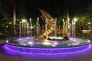
Central park of Balao
|
|||
|
|||
| Motto(s):
Por la Gloria y el Progreso de Balao (For the Glory and Progress of Balao)
|
|||
| Country | |||
| Provinces | Guayas | ||
| Canton | Balao | ||
| Founded | before 1700 | ||
| Area | |||
| • Town | 1.34 km2 (0.52 sq mi) | ||
| Elevation | 10 m (30 ft) | ||
| Population
(2022 census)
|
|||
| • Town | 12,850 | ||
| • Density | 9,590/km2 (24,840/sq mi) | ||
| Demonym(s) | Balaoense | ||
| Time zone | UTC-5 (ECT) | ||
| Website | http://www.municipiodebalao.gob.ec/ | ||
Balao is a town in southern Guayas, Ecuador. It's close to the Azuay and El Oro provinces. Balao is the main town of Balao Canton, which was created in 1987.
In 2022, about 25,655 people lived in Balao Canton. The town is connected to bigger cities like Guayaquil and Machala. It even has its own small airport, called an airstrip.
The town and the canton are named after a type of tree. Another idea is that the name Balao comes from an old tribe called Palau. They might have lived in this area long before Europeans arrived. The most important rivers here are the Balao River, the Jagua River, and the Gala River. Farmers in Balao grow many important crops. These include bananas, cacao, rice, maize (corn), cassava, tomatoes, coffee, and different tropical fruits.
Contents
Exploring Balao's Past
Balao started as a small settlement surrounded by farms. The people who lived there, either native or from nearby areas, made their living by farming and fishing. Balao has been known as a town since the 1700s.
How Balao Became a Parish
In 1831, an official from the Guayas Province visited Balao. He wanted to see what the town produced and sold. This was because the residents asked for Balao to become a "Parish." A parish is like a local district. According to old records from Guayaquil, Balao officially became a parish of the Guayaquil canton on March 19, 1832.
Becoming a Canton
Many years later, in 1986, the people of Balao worked hard for their town to become part of a new canton. A canton is a larger administrative area, similar to a county. Their efforts paid off! Every year on November 17, Balao celebrates its "cantonization." This happened when Law number 75 was passed and published on November 17, 1987. This law clearly set the boundaries for the new Balao Canton. After this, the first Cantonal Council was chosen. Dr. Lisímaco Martillo Landívar became Balao's first mayor.
Balao's Role in History
From October 1941 to February 1942, Balao was important in a historical event. It marked the northern edge of a special area called the "Ecuadorian Demilitarized Zone." This zone was set up to keep peace between countries.
Balao's Weather
| Climate data for Balao (Tenguel), elevation 20 m (66 ft), (1961–1990) | |||||||||||||
|---|---|---|---|---|---|---|---|---|---|---|---|---|---|
| Month | Jan | Feb | Mar | Apr | May | Jun | Jul | Aug | Sep | Oct | Nov | Dec | Year |
| Mean daily maximum °C (°F) | 31.2 (88.2) |
30.8 (87.4) |
31.2 (88.2) |
31.5 (88.7) |
30.7 (87.3) |
29.2 (84.6) |
29.5 (85.1) |
28.3 (82.9) |
27.7 (81.9) |
27.7 (81.9) |
28.3 (82.9) |
29.8 (85.6) |
29.7 (85.4) |
| Daily mean °C (°F) | 25.7 (78.3) |
26.0 (78.8) |
26.2 (79.2) |
26.7 (80.1) |
25.8 (78.4) |
24.7 (76.5) |
24.7 (76.5) |
24.2 (75.6) |
23.8 (74.8) |
23.7 (74.7) |
24.2 (75.6) |
25.0 (77.0) |
25.1 (77.1) |
| Mean daily minimum °C (°F) | 21.2 (70.2) |
20.8 (69.4) |
21.3 (70.3) |
21.6 (70.9) |
21.3 (70.3) |
21.1 (70.0) |
21.1 (70.0) |
21.1 (70.0) |
20.0 (68.0) |
20.2 (68.4) |
20.2 (68.4) |
20.3 (68.5) |
20.8 (69.5) |
| Average precipitation mm (inches) | 132.0 (5.20) |
135.0 (5.31) |
123.0 (4.84) |
100.0 (3.94) |
53.0 (2.09) |
29.0 (1.14) |
18.0 (0.71) |
25.0 (0.98) |
40.0 (1.57) |
57.0 (2.24) |
34.0 (1.34) |
31.0 (1.22) |
777 (30.58) |
| Source: FAO | |||||||||||||
See also

 In Spanish: Balao (Ecuador) para niños
 | William M. Jackson |
 | Juan E. Gilbert |
 | Neil deGrasse Tyson |


