Balgowlah Heights facts for kids
Quick facts for kids Balgowlah HeightsSydney, New South Wales |
|||||||||||||||
|---|---|---|---|---|---|---|---|---|---|---|---|---|---|---|---|

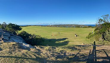
Tania Park, Balgowlah Heights
|
|||||||||||||||
| Population | 3,342 (2016 census) | ||||||||||||||
| Established | 1832 | ||||||||||||||
| Postcode(s) | 2093 | ||||||||||||||
| Elevation | 76 m (249 ft) | ||||||||||||||
| Location | 11 km (7 mi) north-east of Sydney CBD | ||||||||||||||
| LGA(s) | Northern Beaches Council | ||||||||||||||
| State electorate(s) | Manly | ||||||||||||||
| Federal Division(s) | Warringah | ||||||||||||||
|
|||||||||||||||
Balgowlah Heights is a beautiful suburb located in northern Sydney, New South Wales, Australia. It is about 11 kilometers north-east of the main Sydney central business district. This area is part of the Northern Beaches Council and the wider Northern Beaches region. Balgowlah Heights shares its postcode, 2093, with the nearby suburbs of Balgowlah and North Balgowlah.
The suburb sits on a high ridge, reaching up to 80 meters above North Harbour and Middle Harbour. Because of its high position, many houses in Balgowlah Heights have amazing views. You can see across the harbour to the Eastern Suburbs and even the Spit Bridge. The area also has natural bushland, which is part of the National Park. This park includes areas around Dobroyd Head and Grotto Point. Tania Park, on the eastern side, is a great place to relax. From there, you can watch the Manly ferry as it travels to Circular Quay.
Discovering Balgowlah Heights' Past
The name Balgowlah comes from an Aboriginal word. It means 'north harbour,' which describes its location on Port Jackson. The name was first used in 1832. However, the suburb as we know it today was mostly developed much later. Most of the homes and buildings in Balgowlah Heights were built in the 1960s.
Who Lives in Balgowlah Heights?
According to the 2016 census, 3,342 people lived in Balgowlah Heights. Most residents, about 67.3%, were born in Australia. The next largest group, 10.7%, came from England. When it comes to languages spoken at home, 87.0% of people spoke only English. For religious beliefs, the most common responses were No Religion (32.8%), Catholic (24.2%), and Anglican (24.2%).
Local Schools
Balgowlah Heights has a local public school for children.
- Balgowlah Heights Public School


