Balneário Camboriú facts for kids
Quick facts for kids
Balneário Camboriú
|
|||
|---|---|---|---|
|
Municipality
|
|||
| Municipality of Balneário Camboriú | |||
|
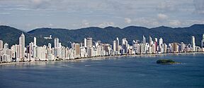
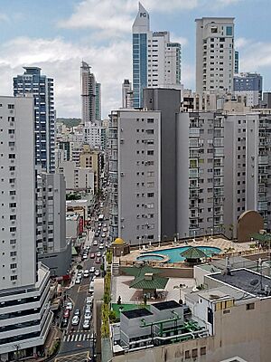
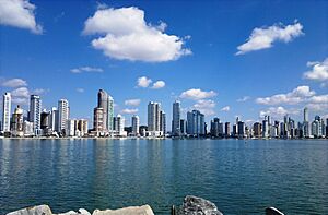
Skyline of Balneário Camboriú
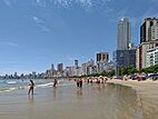
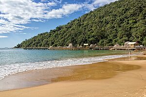
Praia Central
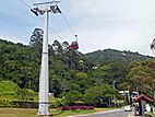
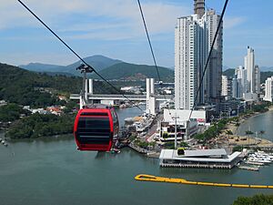
Parque Unipraias cable car
|
|||
|
|||
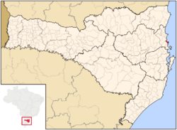
Location of Balneário Camboriú
|
|||
| Country | |||
| Region | Southern | ||
| State | |||
| Incorporated | July 20, 1964 | ||
| Area | |||
| • Municipality | 46 km2 (17.9 sq mi) | ||
| Elevation | 2 m (7 ft) | ||
| Population
(2020)
|
|||
| • Municipality | 139,155 | ||
| • Density | 30,707/km2 (7,953,1/sq mi) | ||
| • Metro | 390,990 | ||
| Time zone | UTC−3 (BRT) | ||
| • Summer (DST) | -3 | ||
| Postal Code |
88330-000
|
||
| Area code(s) | +55 47 | ||
| HDI (2010) | 0.845 – very high | ||
Balneário Camboriú is a lively city on the coast in southern Brazil. It is located in the state of Santa Catarina. The city is built on hills that go right down to the sea.
It is a very popular place for tourists from South America. Many people visit its main ocean road, Avenida Atlântica. The city's population of about 145,000 people can grow to over one million in the summer!
Balneário Camboriú is known for its special cable car. This cable car connects the city's main beach to Laranjeiras beach. The city is about 10 kilometers (6 miles) south of Itajaí. It is also 96 kilometers (60 miles) south of Joinville. The state capital, Florianópolis, is about 80 kilometers (50 miles) north.
The city is served by Ministro Victor Konder International Airport. This airport is in the nearby town of Navegantes.
The meaning of the city's name is not fully known. Some say it means "River filled with Snook," which is a common fish there.
Contents
Fun Facts About Balneário Camboriú
Ilha das Cabras, or Goats' Island, is right across from the city. It is too small for people to live on, but it is lit up at night. Visitors can take 17th-century style pirate ships to Laranjeiras Beach. These ships sail around Goats' Island before returning to Balneário Camboriú.
The city also has a large statue similar to Rio de Janeiro's famous Christ the Redeemer. This statue is called Cristo Luz (Christ Light). It stands on top of Morro da Cruz hill. Cristo Luz shows Jesus holding a circular "broad-brimmed hat" on his shoulder. This hat stands for the sun. It also has a spotlight that shines over the city. The Cristo Luz is 33 meters (108 feet) tall. This is only five meters shorter than the Redeemer statue. Colorful lights inside and outside the statue light it up at night.
Another common sight in the city is paragliders flying over the beach. They launch from a special area in Praia dos Amores. To the west, the city is next to the Camboriú River. This river meets the ocean at the southern edge of the city center. This is also where the cable car starts from the main beach.
Balneário Camboriú has been called the "Brazilian Dubai". This is because it has many tall skyscrapers and attracts wealthy tourists.
City History
Early Settlers
The Tupi-Guaraní tribe lived in this area first. European families began to settle here in 1758. They moved from Porto Belo to a place they called Our Lady of Bon Sucesso. This area is now known as Barra. Francisco Garcia and his family also lived nearby. This is why the village became known as Garcia. Baltasar Pinto Corrêa, from the Azores, was another early settler. Later, groups of Germans came from other valleys. They were looking for good farming land. They built the church of Our Lady of Good Success. They also founded the town of Bom Sucesso.
Becoming a City
In 1848, the area became a district of the city of Itajaí. It stayed that way until 1884. By 1930, people started to choose this beautiful coastal spot for vacations. Two years later, the town's first hotel was built. This hotel was at the meeting point of Central and Atlantic Avenues. In 1964, the district became its own city. It was first named Balneário de Camboriú. In 1979, its name was changed to Balneário Camboriú.
What Does the Name Mean?
There are two ideas about where the name Camboriú comes from. One idea is that people used to say "camba the river." This was because the river had a sharp bend near where it met the ocean. "Cambar" is a Portuguese word that can mean "to sharply change direction." Another idea comes from a local priest, Raulin Reitz. He said that old maps showed the name Rio Camboriú even before Europeans arrived. He believed the name Camboriú comes from the Tupi language.
People and Population
Balneário Camboriú has grown a lot over the years. In 1970, its population was around 10,839 people. By 2022, it had grown to 139,155 residents.
Ethnic Backgrounds
The first European settlers in this area were from the Azores. However, most people living in Balneário Camboriú today have German family roots.
| Color / Race | % |
|---|---|
| White | 92.5% |
| Black | 1.2% |
| Pardo (Multiracial) | 5.6% |
| Asian | 0.7% |
City Climate
The climate in Balneário Camboriú is generally mild. It is known as a humid subtropical climate with hot summers. In summer, temperatures are usually around 25°C (77°F). They rarely reach 40°C (104°F). In winter, the average temperature is about 15°C (59°F). Early mornings can be cooler, sometimes between 0°C and 4°C (32°F and 39°F). The average temperature for the whole year is 19°C (66°F).
The city usually has a humid climate. It gets about 1,500 mm (59 inches) of rain each year. There isn't a specific dry season. The sea water temperature changes with the seasons. In winter, it averages 16°C (61°F). In summer, it averages 24.4°C (76°F). Spring and autumn temperatures are around 21°C (70°F). February and March are the best months for enjoying the beach.
City Economy
The main way the city makes money is through its real estate market. This means buying and selling homes and buildings. Local companies build many tall buildings. Some beachfront high-rises can be very expensive. The city has some of the tallest buildings in the southern hemisphere. Some are over 280 meters (918 feet) tall.
The number of people in the city grows a lot in summer. This can sometimes put a strain on city services. For example, water quality for beaches or fresh water supply can be affected. The city has been working to fix these issues.
Getting to Balneário Camboriú is mainly by the BR-101 highway. When many tourists visit, this can cause big traffic jams. The closest airport is in Navegantes, about 16 km (9.9 miles) away. A new cruise ship terminal is planned to be ready in 2025 or 2026. This will make it even easier for tourists to visit.
Near the future cruise terminal, there is a cable car. This cable car is part of the Tourist Complex UNIPRAIAS. It connects the main beach to the nearby Laranjeiras beach. There are many other beaches south of Balneário Camboriú. These include Bamboos, Estaleiro, Estaleirinho, and Pinho beach. These beaches are connected by the Interpraias road.
Other important parts of the city's economy are trade and services. The city has about 100 hotels. It also has 350 large commercial buildings. There are 1,035 tall residential buildings for middle and upper-class families.
Most tourists who visit Balneário Camboriú are from Brazil. About 45% come from the State of São Paulo. Many others come from nearby states like Paraná and Rio Grande do Sul. For international visitors, about 30% come from Argentina. The rest come from neighboring countries like Uruguay, Paraguay, and Chile.
Places to See
- Parque Unipraias – This park includes parts of the Mata Atlântica (Atlantic Woods). These woods are very rare now. The park also offers amazing ocean views.
- Cristo Luz – This is a 33-meter (108-foot) tall monument. It stands on top of Morro da Cruz. There is a tourist area around it with restaurants, shops, live shows, and playgrounds.
- Parque Cyro Gevaerd (also called Santur) – This park has a zoo with birds, an aquarium, and museums. The museums include an Archeology and Oceanography Museum and a Fishermen Museum. There is also a Minifarm. You can see local animals and plants in their natural homes. The zoo has lions, tigers, monkeys, and alligators.
- Capela de Santo Amaro (St. Amaro Chapel) – This chapel was built in 1810. It was made with a mix of whale oil and mortar. In June 1998, it was named a local Historical Landmark. It is in the Bairro da Barra neighborhood. It is right in front of the Fishermen Plaza and the School of Arts.
- Parque Natural Municipal Raimundo Gonçalez Malta – This park was once known as Parque Ecológico Rio Camboriú. It has many types of local plants. There are gardens like Bromelia, Viveira da Mata Atlântica, and São Francisco Garden. You can find several walking trails, playgrounds, and parking lots. It is located at the end of Angelina Street.
Music Scene
Forbes magazine wrote in 2012 about how popular electronic music was becoming in Brazil. Balneário Camboriú was called the country's "capital of electronic music." According to Forbes, Balneário Camboriú is home to two of Brazil's best clubs. These are the Warung club (in Itajaí) and the Green Valley club. Forbes said these clubs could make a lot of money in one night. Green Valley has been named the top nightclub in the world many times by DJ Mag magazine. This has made the city a top spot for electronic music worldwide.
Sister Cities
Balneário Camboriú has "sister city" relationships with:
See also
 In Spanish: Balneario Camboriú para niños
- List of tallest buildings in Balneário Camboriú
 | Toni Morrison |
 | Barack Obama |
 | Martin Luther King Jr. |
 | Ralph Bunche |


