Balranald facts for kids
Quick facts for kids BalranaldNew South Wales |
|||||||||
|---|---|---|---|---|---|---|---|---|---|

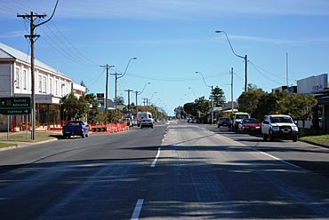
The Sturt Highway at Balranald
|
|||||||||
| Population | 1,063 (2021 census) | ||||||||
| Established | 1851 | ||||||||
| Postcode(s) | 2715 | ||||||||
| Elevation | 61 m (200 ft) | ||||||||
| Location | |||||||||
| LGA(s) | Balranald Shire | ||||||||
| County | Caira | ||||||||
| State electorate(s) | Murray | ||||||||
| Federal Division(s) | Farrer | ||||||||
|
|||||||||
Balranald is a town in the far south-western part of New South Wales, Australia. It's located in the Murray region, within the Balranald Shire.
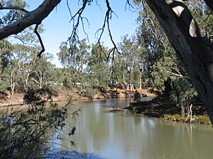
The town sits where the Sturt Highway crosses the Murrumbidgee River. This area is quite remote and semi-desert. Even though Balranald is in New South Wales, people there often watch TV channels from Victoria. They can also get newspapers from both Sydney and Melbourne. From 2010 to 2015, Balranald was shown in Australian tourism ads. These ads highlighted the beautiful native plants, including over 30 types of shrubs unique to the area.
Contents
History of Balranald
Balranald is on the traditional lands of the Muthi Muthi people. This area has a long history before European settlers arrived. A strong Indigenous culture continues to be important here today.
How the Town Began
Around 1847–1848, a government official named George James McDonald came to this spot. He was the Commissioner for Crown Lands for the Lower Darling District. McDonald chose this location as his base and set up camp. Soon after, in 1848, Leighton Robinson and Thomas Duggan opened a general store. A public-house, called the Balranald Inn, was also built by Mr Robertson that same year.
In 1849, Commissioner McDonald suggested that a town should be officially started here. McDonald was from Scotland, born in a place called Balranald on North Uist. He decided to name the new settlement after his birthplace. He believed the town's location on the Murrumbidgee River would be important. This was because steam boats were soon expected to travel on the Murray River.
A surveyor named Francis MacCabe mapped out the area in 1849. He included a spot for a new town, which was officially approved in November 1849. The first land sale for Balranald happened on January 14, 1852. An official post office opened in the town on March 1, 1852. Mail services also began along the Murrumbidgee River.
More businesses opened as the town grew. The Carriers' Arms hotel was built around 1852. In 1859, Denis Hanan bought a special boat called a punt from Captain Cadell. He used it to help people cross the river. The gold rushes in Victoria, which started around the same time, greatly affected the Riverina region. They made the market for livestock much bigger. However, Balranald's growth slowed down a bit by the late 1850s.
Growth Up to 1900
Balranald became a key place for livestock to cross the river from South Australia. In 1866, Peter Young built the Royal Hotel and started another punt service. A toll-house was later built near Young's punt. The Commercial Hotel opened in 1869. In 1871, a new Post & Telegraph Office was built. This was the first brick building in Balranald.
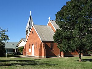
The first church in Balranald was the Church of England, which began services in 1873. A Roman Catholic church was finished in 1875. A local newspaper, the Riverina Recorder, started in 1877.
By 1881, Balranald had about 400 people. It had five stores and six hotels. Balranald became a Municipality in 1882, and Herman Levy was chosen as its first mayor. A special bridge with a lift-span was built over the Murrumbidgee River. It opened in April 1883. A new Court House was built in 1885. By 1887, Balranald was described as a "squarely built little town." It had two churches, a hospital, a bank, and a Masonic Hall. A Presbyterian church was also built by 1888.
From 1901 to Today
The first public telephone service in Balranald was set up in 1911. The local council faced some money problems in 1912, but they were solved the next year.
In March 1926, Balranald was connected to the Victorian railway system. This allowed trains to travel to Echuca. However, the Balranald railway line is now closed.
In 1956, the local government changed its name to the Shire of Balranald. Shire Presidents took over from Mayors. New offices for the Balranald Shire Council opened in August 1964. They are located on Market Street, next to the Police Station.
Climate
Balranald has a semi-arid climate. This means it has hot summers and cool winters. It gets a mild amount of rain throughout the year. The winter months and early spring usually have more rainy days.
Weather records for Balranald have been kept since 1879. Temperatures can vary a lot during the year. The average highest temperature in January is 33.0°C (91.4°F). The average lowest temperature in July is 3.5°C (38.3°F). The hottest temperature ever recorded was 47.7°C (117.9°F) in January 1908. The coldest was -4.8°C (23.4°F) in July 1982. The town gets about 324.1 mm (12.76 in) of rain each year.
| Climate data for Balranald RSL | |||||||||||||
|---|---|---|---|---|---|---|---|---|---|---|---|---|---|
| Month | Jan | Feb | Mar | Apr | May | Jun | Jul | Aug | Sep | Oct | Nov | Dec | Year |
| Record high °C (°F) | 47.7 (117.9) |
46.2 (115.2) |
42.2 (108.0) |
37.6 (99.7) |
35.6 (96.1) |
25.6 (78.1) |
27.0 (80.6) |
30.1 (86.2) |
36.7 (98.1) |
40.8 (105.4) |
44.6 (112.3) |
45.6 (114.1) |
47.7 (117.9) |
| Mean daily maximum °C (°F) | 33.0 (91.4) |
32.5 (90.5) |
29.2 (84.6) |
24.0 (75.2) |
19.4 (66.9) |
16.1 (61.0) |
15.7 (60.3) |
17.6 (63.7) |
20.9 (69.6) |
24.5 (76.1) |
28.1 (82.6) |
30.9 (87.6) |
24.3 (75.7) |
| Mean daily minimum °C (°F) | 16.4 (61.5) |
16.3 (61.3) |
13.6 (56.5) |
9.6 (49.3) |
6.8 (44.2) |
4.3 (39.7) |
3.5 (38.3) |
4.7 (40.5) |
7.1 (44.8) |
9.8 (49.6) |
12.6 (54.7) |
14.7 (58.5) |
10.0 (50.0) |
| Record low °C (°F) | 7.5 (45.5) |
7.2 (45.0) |
0.6 (33.1) |
0.8 (33.4) |
−3.0 (26.6) |
−3.3 (26.1) |
−4.8 (23.4) |
−2.4 (27.7) |
−2.2 (28.0) |
−3.9 (25.0) |
3.5 (38.3) |
5.5 (41.9) |
−4.8 (23.4) |
| Average precipitation mm (inches) | 22.4 (0.88) |
25.4 (1.00) |
22.5 (0.89) |
23.2 (0.91) |
31.3 (1.23) |
29.7 (1.17) |
26.5 (1.04) |
29.6 (1.17) |
29.1 (1.15) |
30.8 (1.21) |
28.0 (1.10) |
25.6 (1.01) |
324.1 (12.76) |
| Average rainy days | 3.0 | 3.0 | 3.5 | 4.0 | 6.2 | 7.4 | 8.1 | 7.9 | 6.6 | 5.9 | 4.7 | 3.9 | 64.2 |
Agriculture
Farming activities in the Balranald area include raising sheep. People also cut wood and make charcoal. Some areas along the rivers use irrigation to grow crops.
Attractions
The Balranald Shire is home to Yanga National Park. It also includes parts of the World Heritage listed Mungo National Park. These parks offer amazing natural sights and history.
Australia's First Telephone
The very first telephone used in Australia was set up at a nearby property called "Yanga" station. It was used to connect the main house with the shearers' quarters. James Cromyn installed it. He followed instructions sent from England by his uncle, Alexander Graham Bell, who helped invent the telephone.
The Balranald telephone exchange was updated from manual to automatic operation between 1988 and 1990. This made phone calls much easier.
Community
The town has an Australian rules football team. They play in the Central Murray Football League.
Golf fans can play at the Balranald Golf and Sporting Club. It is located on O'Connor Street.
Population
| Historical population | ||
|---|---|---|
| Year | Pop. | ±% |
| 1921 | 874 | — |
| 1933 | 1,261 | +44.3% |
| 1947 | 1,249 | −1.0% |
| 1954 | 1,273 | +1.9% |
| 1961 | 1,331 | +4.6% |
| 1966 | 1,490 | +11.9% |
| 1971 | 1,424 | −4.4% |
| 1976 | 1,396 | −2.0% |
| 1981 | 1,442 | +3.3% |
| 1986 | 1,398 | −3.1% |
| 1991 | 1,327 | −5.1% |
| 1996 | 1,419 | +6.9% |
| 2001 | 1,284 | −9.5% |
| 2006 | 1,216 | −5.3% |
| 2011 | 1,159 | −4.7% |
| 2016 | 1,159 | +0.0% |
| 2021 | 1,063 | −8.3% |
| Source: Australian Bureau of Statistics data. | ||
The 2021 census counted 1,063 people living in Balranald.
- About 9.6% of the people were Aboriginal and Torres Strait Islander.
- Most people (78.2%) were born in Australia.
- Almost 80% (79.4%) of people spoke only English at home.
- The most common religions were Catholic (29.6%), Anglican (13.5%), and No Religion (26.0%).
 | Jewel Prestage |
 | Ella Baker |
 | Fannie Lou Hamer |


