Banks Island (British Columbia) facts for kids
|
Native name:
Ḵaa'al
|
|
|---|---|

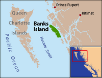
Banks Island is located on the east side of Hecate Strait
|
|
| Geography | |
| Location | Hecate Strait |
| Coordinates | 53°25′N 130°10′W / 53.417°N 130.167°W |
| Area | 1,005 km2 (388 sq mi) |
| Length | 72 km (44.7 mi) |
| Width | 9.7–18 km (6.0–11.2 mi) |
| Highest elevation | 536 m (1,759 ft) |
| Highest point | unnamed |
| Administration | |
| Province | British Columbia |
Banks Island is a beautiful island located off the coast of British Columbia, a province in Canada. It sits in the Hecate Strait, which is a body of water on the west coast of Canada.
This island is found south of the city of Prince Rupert. It is also east of the Queen Charlotte Islands. To the east of Banks Island, you'll find Pitt Island and McCauley Island, separated by Principe Channel. To the west is Bonilla Island. South of Banks Island is the Estevan Group of islands, and beyond that is Caamaño Sound.
Banks Island is about 72 kilometres (45 mi) long. Its width changes, ranging from 9.7 kilometres (6.0 mi) to 18 kilometres (11 mi). The total area of the island is 1,005 square kilometres (388 sq mi). The highest point on the island reaches 536 metres (1,759 ft) above sea level. It is part of the Skeena-Queen Charlotte Regional District.
The island got its name in 1787. Archibald Menzies, a botanist and surgeon, named it. He was on a fur trading ship called the Princess Royal. Menzies named the island after Sir Joseph Banks. Sir Joseph Banks was a very important person at the time. He was the president of the Royal Society and had traveled with James Cook on his famous voyages. Banks also encouraged British fur trading trips to the Pacific Northwest.
Contents
Exploring Banks Island's Past
Banks Island has an interesting history, especially regarding early explorations.
First Visitors and Explorers
In the late summer of 1787, two British fur traders arrived at Banks Island. Their names were James Colnett and Charles Duncan. They anchored their ships, the Prince of Wales and the Princess Royal, in a place they called Calamity Bay. This bay is at the south end of Banks Island.
Their ships stayed there for about eleven weeks to be repaired. During this time, the British explorers met some of the Kitkatla Tsimshian people. These were some of the first meetings between the British and the local Indigenous groups in this area.
Mapping the Coast
While their ships were being fixed, the British explorers used smaller boats. They explored the many waterways around Banks Island. This included places like Principe Channel, Douglas Channel, and Laredo Sound. Their explorations were very important. They created some of the first detailed maps of this part of the coast. These maps helped future explorers understand the area better.
Spanish Exploration
A few years later, in 1792, a Spanish explorer named Jacinto Caamaño visited the region. He sailed through Principe Channel in his ship, the Aranzazu. Caamaño used copies of the maps made by Colnett. These maps showed some areas that hadn't been fully explored yet.
Because of this, the Viceroy of New Spain asked Caamaño to lead another expedition. Caamaño spent about a month at the southern end of Pitt Island. During this time, he had many interactions with the Tsimshian people who lived on Pitt and Banks Islands. His voyage added more details to the maps of the coast.
 | Ernest Everett Just |
 | Mary Jackson |
 | Emmett Chappelle |
 | Marie Maynard Daly |

