Bannock Pass facts for kids
Quick facts for kids Bannock Pass |
|
|---|---|

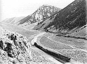
A postcard showing a Gilmore and Pittsburgh Railroad train climbing the west side of Bannock Pass.
|
|
| Elevation | 7,684 ft (2,342 m)[1] |
| Traversed by | |
| Location | Lemhi County, Idaho / Beaverhead County, Montana, United States |
| Range | Rocky Mountains |
| Coordinates | 44°48′52″N 113°16′19″W / 44.81444°N 113.27194°W |
Bannock Pass is a high mountain pass located in the Rocky Mountains. It sits right on the border between Montana and Idaho. This pass is also part of the Continental Divide. This means that water on one side flows to the Pacific Ocean, and water on the other side flows to the Atlantic Ocean.
The pass is very high up, at about 7,684 feet (2,342 meters) above sea level. A road crosses the pass, connecting Leadore, Idaho to Dillon, Montana. This road is known as Idaho State Highway 29 in Idaho and Montana Secondary Highway 324 in Montana.
Contents
What is Bannock Pass?
Bannock Pass is a low point between mountains. It makes it easier for people to travel from one side of a mountain range to the other. It is found in the Beaverhead Mountains, which are part of the larger Bitterroot Range. These mountains are a big part of the Rocky Mountains.
Where is it exactly?
The pass is located right on the border between Lemhi County, Idaho and Beaverhead County, Montana. It's a key spot on the Continental Divide, which is like a giant natural "watershed" line across North America.
Don't Get Confused!
There's another pass nearby called Bannack Pass. It sounds very similar to Bannock Pass. Bannack Pass is about 33 miles (53 kilometers) to the southeast. It is also in the Beaverhead Mountains, on the Montana-Idaho border, and on the Continental Divide. Both passes are almost the same height, around 7,679 feet (2,340 meters). So, it's easy to mix them up!
A Look Back: History of Bannock Pass
Bannock Pass gets its name from the Bannock Native American people. They lived in this area for a very long time.
The Railroad Through the Pass
In the early 1900s, a railroad was built through this area. The Gilmore and Pittsburgh Railroad worked on this project in 1909 and 1910. To make sure the train could climb the steep mountains, the railroad used special zig-zag tracks called "switchbacks." They also dug a tunnel under the very top of the pass. This tunnel was a bit east of where the main highway is today. The railroad stopped using this route in 1939.
 | William L. Dawson |
 | W. E. B. Du Bois |
 | Harry Belafonte |

