Leadore, Idaho facts for kids
Quick facts for kids
Leadore, Idaho
|
|
|---|---|

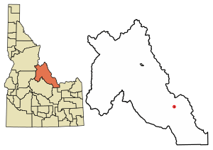
Location of Leadore in Lemhi County, Idaho.
|
|
| Country | United States |
| State | Idaho |
| County | Lemhi |
| Area | |
| • Total | 0.31 sq mi (0.80 km2) |
| • Land | 0.31 sq mi (0.80 km2) |
| • Water | 0.00 sq mi (0.00 km2) |
| Elevation | 5,971 ft (1,820 m) |
| Population
(2010)
|
|
| • Total | 105 |
| • Estimate
(2019)
|
106 |
| • Density | 343.04/sq mi (132.62/km2) |
| Time zone | UTC-7 (Mountain (MST)) |
| • Summer (DST) | UTC-6 (MDT) |
| ZIP code |
83464
|
| Area code(s) | 208 |
| FIPS code | 16-45910 |
| GNIS feature ID | 2411640 |
Leadore is a small town in Lemhi County, Idaho, United States. It is located in the beautiful Lemhi Valley. In 2010, the town had a population of 105 people. Leadore is known for its history with railroads.
Contents
History of Leadore
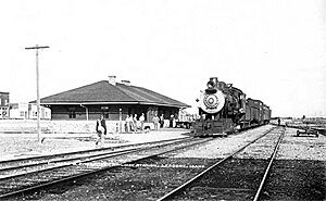
The town of Leadore started in 1910. This was when the Gilmore and Pittsburgh Railroad was built. The railroad connected areas from Armstead, Montana, over Bannock Pass, and into the Lemhi Valley.
The original plan for the train station was in a town called Junction, Idaho. However, the land owner there refused to sell the land. So, the station was built in Leadore instead.
Leadore became an important place for the railroad. It had the railroad's repair shops. It was also where a special branch line to Gilmore, Idaho connected to the main railway line. Even though the railroad stopped running in 1939, Leadore has remained the biggest town in its area.
In 2001, a new building was constructed in Leadore. It looks just like the town's old railway station. This new building now serves as the town's community center.
Geography and Location
Leadore is found in the southeastern part of Lemhi County. It sits within the Lemhi Valley. The Lemhi River flows along the northeast side of the town. This river then runs northwest to join the Salmon River near Salmon, Idaho.
Roads and Travel
Idaho State Highway 28 (also called Railroad Street) goes right through the middle of Leadore. If you travel northwest on this highway, you will reach Salmon, the county seat, about 45 miles away. If you go southeast, you will reach Interstate 15 at Sage Junction, about 90 miles away.
Idaho State Highway 29 starts in Leadore and heads northeast. It goes about 13 miles to the Montana state line at Bannock Pass. This pass is on the Continental Divide. From Bannock Pass, Montana Secondary Highway 324 continues northeast. It connects to Interstate 15 near Clark Canyon Dam, which is about 48 miles northeast of Leadore.
Town Size
According to the United States Census Bureau, Leadore covers a total area of about 0.31 square miles (0.80 square kilometers). All of this area is land.
Climate
Leadore has a steppe climate. This type of climate means it is generally dry. It gets some rain, but not enough to be a forest.
| Climate data for Leadore, Idaho, 1991–2020 normals, extremes 1965–present | |||||||||||||
|---|---|---|---|---|---|---|---|---|---|---|---|---|---|
| Month | Jan | Feb | Mar | Apr | May | Jun | Jul | Aug | Sep | Oct | Nov | Dec | Year |
| Record high °F (°C) | 53 (12) |
56 (13) |
69 (21) |
77 (25) |
91 (33) |
97 (36) |
102 (39) |
99 (37) |
93 (34) |
84 (29) |
69 (21) |
60 (16) |
102 (39) |
| Mean maximum °F (°C) | — | — | — | — | — | — | — | — | — | 55.4 (13.0) |
39.5 (4.2) |
28.5 (−1.9) |
55.4 (13.0) |
| Mean daily maximum °F (°C) | 29.7 (−1.3) |
33.6 (0.9) |
43.1 (6.2) |
52.3 (11.3) |
62.4 (16.9) |
70.8 (21.6) |
82.5 (28.1) |
81.4 (27.4) |
71.0 (21.7) |
55.4 (13.0) |
39.5 (4.2) |
28.5 (−1.9) |
54.2 (12.3) |
| Daily mean °F (°C) | 17.3 (−8.2) |
20.7 (−6.3) |
30.9 (−0.6) |
38.6 (3.7) |
47.3 (8.5) |
54.2 (12.3) |
62.0 (16.7) |
60.9 (16.1) |
52.3 (11.3) |
40.2 (4.6) |
27.6 (−2.4) |
17.1 (−8.3) |
39.1 (4.0) |
| Mean daily minimum °F (°C) | 4.9 (−15.1) |
7.8 (−13.4) |
18.7 (−7.4) |
25.0 (−3.9) |
32.1 (0.1) |
37.7 (3.2) |
41.4 (5.2) |
40.4 (4.7) |
33.6 (0.9) |
24.9 (−3.9) |
15.7 (−9.1) |
5.7 (−14.6) |
24.0 (−4.4) |
| Record low °F (°C) | −38 (−39) |
−38 (−39) |
−21 (−29) |
−8 (−22) |
4 (−16) |
19 (−7) |
24 (−4) |
19 (−7) |
10 (−12) |
−14 (−26) |
−22 (−30) |
−40 (−40) |
−40 (−40) |
| Average precipitation inches (mm) | 0.32 (8.1) |
0.31 (7.9) |
0.53 (13) |
0.87 (22) |
1.55 (39) |
1.62 (41) |
0.90 (23) |
0.90 (23) |
0.79 (20) |
0.68 (17) |
0.36 (9.1) |
0.51 (13) |
9.34 (236.1) |
| Source 1: NOAA (precipitation 1981–2010) | |||||||||||||
| Source 2: National Weather Service | |||||||||||||
Population and People
| Historical population | |||
|---|---|---|---|
| Census | Pop. | %± | |
| 1950 | 159 | — | |
| 1960 | 112 | −29.6% | |
| 1970 | 111 | −0.9% | |
| 1980 | 114 | 2.7% | |
| 1990 | 74 | −35.1% | |
| 2000 | 90 | 21.6% | |
| 2010 | 105 | 16.7% | |
| 2019 (est.) | 106 | 1.0% | |
| U.S. Decennial Census | |||
2010 Census Information
In 2010, the census counted 105 people living in Leadore. There were 48 households and 24 families. The population density was about 338 people per square mile. There were 81 housing units in total.
All the people living in Leadore at that time were identified as White.
Households and Families
Out of the 48 households, about 29% had children under 18 living there. About 42% were married couples living together. A small number of households (2.1%) had a female head with no husband. Another small number (6.3%) had a male head with no wife. Half of all households (50%) were made up of individuals, not families. Also, 31% of households had someone living alone who was 65 years old or older.
The average household had 2.19 people. The average family had 3.38 people.
Age and Gender
The average age of people in Leadore was 41.3 years. About 28% of residents were under 18 years old. About 7% were between 18 and 24 years old. Roughly 20% were between 25 and 44. About 26% were between 45 and 64. Finally, 20% of the people were 65 years old or older.
In terms of gender, 51.4% of the population was male. The other 48.6% was female.
See also
 In Spanish: Leadore para niños
 | Misty Copeland |
 | Raven Wilkinson |
 | Debra Austin |
 | Aesha Ash |


