Barnaslingan facts for kids
Quick facts for kids Barnaslingan |
|
|---|---|
| Barr na Slinneán | |

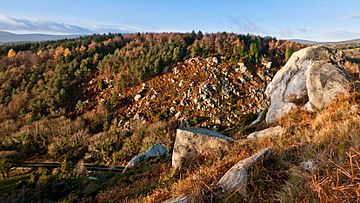
Looking across The Scalp from the summit of Barnaslingan
|
|
| Highest point | |
| Elevation | 238 m (781 ft) |
| Geography | |
| Location | County Dublin, Ireland |
| Parent range | Dublin Mountains |
| OSI/OSNI grid | O2191620294 |
| Topo map | OSI Discovery #50 |
Barnaslingan is a hill in County Dublin, Ireland. It stands about 238 meters (781 feet) tall. The name Barnaslingan comes from Irish words meaning "summit of the shoulder blades." This hill is famous for a special natural spot called The Scalp. The Scalp is a deep, narrow valley found to the west of Barnaslingan's top.
In 1837, a writer named Samuel Lewis described The Scalp. He called it a "deep natural chasm" with high, sloping sides. He noted that huge pieces of rock had fallen from these sides. These rocks were piled up, looking as if they might fall at any moment.
Contents
How The Scalp Was Formed
The Scalp is a narrow valley that was shaped by glaciers. This happened about 12,000 years ago during the last Ice Age. During that time, a giant sheet of ice covered the Irish Sea. It also stretched inland over the Dublin-Wicklow Mountains.
As the ice began to melt, several large lakes formed. One of these lakes was near Enniskerry. It was held in place by the mountains and the ice sheet. The huge amount of water pushed hard against the ground. Eventually, it found a weak spot in the rock. This pressure carved out the channel we now call The Scalp.
Similar valleys were created in nearby County Wicklow. These include the Glen of the Downs and the Rocky Valley. The Scalp is special because it's a great example of a valley formed by a glacial lake overflowing. Because of this, it is listed as an Area of Scientific Interest.
Animals and Nature
The steep, rocky slopes of The Scalp are home to many animals. You might see a group of feral goats living there. The area is also a natural home for deer and badgers. It's a great place to see wildlife in its natural habitat.
Roads and Buildings
The R117 road goes right through The Scalp. This road connects Kilternan and Enniskerry. Even though the valley floor is quite narrow, a few buildings are located along the road.
One of the most noticeable buildings is the Scalp Service Station. Before 1963, this building was a dance hall called "The New Era." Another building, which is now a private house, used to be a tea room called "Butler's Tea House."
Nearby Attractions
Overlooking The Scalp area is the Kilternan Golf and Country Club. This place first opened as a hotel in 1970. It was built around an old house from the 1800s called Springfield. This house was once the home of a poet and mathematician named George Darley (1795-1846).
The land around the hotel is also home to a dry ski slope. This is where the Ski Club of Ireland has its headquarters. The ski slope is still open and used by many people.
Walking Trails
Barnaslingan is part of a forest recreation area. This area is owned by a company called Coillte. It is managed by the Dublin Mountains Partnership. There are several walking trails in the woods that are clearly marked. You can also find a permanent orienteering course there. Barnaslingan is also a part of the longer walking path called the Dublin Mountains Way.
 | Selma Burke |
 | Pauline Powell Burns |
 | Frederick J. Brown |
 | Robert Blackburn |


