
Barren Island facts for kids

Barren Island
Location in Andaman and Nicobar Islands

Barren Island
Location in Bay of Bengal
Location of Barren Island
|
|
| Geography | |
|---|---|
| Location | Bay of Bengal |
| Coordinates | 12°17′N 93°52′E / 12.28°N 93.86°E |
| Archipelago | Andaman Islands |
| Adjacent bodies of water | Indian Ocean |
| Total islands | 1 |
| Major islands |
|
| Area | 8.34 km2 (3.22 sq mi) |
| Length | 3.4 km (2.11 mi) |
| Width | 3.1 km (1.93 mi) |
| Coastline | 12.38 km (7.693 mi) |
| Highest elevation | 353 m (1,158 ft) |
| Administration | |
| District | North and Middle Andaman |
| Island group | Andaman Islands |
| Island sub-group | East Volcano Islands |
| Taluk | Rangat Taluk |
| Demographics | |
| Population | 0 (2017) |
| Pop. density | 0.00 /km2 (0 /sq mi) |
| Additional information | |
| Time zone | |
| PIN | 744202 |
| Telephone code | 031927 |
| ISO code | IN-AN-00 |
| Avg. summer temperature | 30.2 °C (86.4 °F) |
| Avg. winter temperature | 23.0 °C (73.4 °F) |
| Census Code | 35.639.0004 |

| Barren Volcano | |
|---|---|

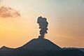
Barren Island erupting in 1995
|
|
| Geography | |
| Location | Andaman Islands, India |
| Geology | |
| Mountain type | Stratovolcano with pyroclastic cones |
| Last eruption | 2019 |
Barren Island is a special island found in the Andaman Sea. It's famous because it's the only confirmed active volcano in South Asia. This means it's the only volcano in this part of the world that still erupts! It's part of India's Union Territory of Andaman and Nicobar Islands. The island is about 138 kilometers (86 miles) northeast of Port Blair, which is the capital city of the territory.
Contents
Volcano's History
The first time people recorded the volcano erupting was way back in 1787. Since then, it has erupted more than ten times. The most recent eruption happened in 2017.
After the first eruption in 1787, more eruptions were noted in 1789, 1795, 1803–04, and 1852. Then, the volcano was quiet for about 150 years. This quiet period is called "dormancy."
In 1991, the island had another big eruption that lasted for six months. This eruption caused a lot of damage, especially to the animals living there.
Impact on Animals
After the 1991 eruption, a team of scientists visited Barren Island. They wanted to see how the eruption affected the animals. Their report showed that many bird species and their numbers had gone down.
The scientists only saw 6 out of the 16 types of birds known to live on the island. The Pied Imperial Pigeon was the most common bird they found. At night, they also saw one type of rat and 51 different kinds of insects. The report also mentioned that the volcano was still letting out gas.
More eruptions happened in 1994–95 and again from 2005–07. The 2005–07 eruption might have been connected to the huge 2004 Indian Ocean earthquake. A lighthouse built in 1993 was even destroyed by these eruptions.
Recent Activity
On January 23, 2017, a team of scientists saw the volcano erupting again. The team leader, Abhay Mudholkar, said the volcano was erupting in short bursts, lasting about five to ten minutes.
During the day, they only saw clouds of ash. But after the sun went down, they saw bright red lava shooting out of the volcano's opening. Hot lava also flowed down its sides.
Scientists have studied the rocks from Barren Island. They found that the oldest lava flows on land are about 1.6 million years old. The island itself sits on very old ocean floor, about 106 million years old. All the eruptions recorded have been on the lower side of how powerful volcanoes can be. For example, the 2017 eruption was rated as a 2 on a scale that measures volcano power.
Island's Geography
Barren Island is located in a chain of volcanoes. This chain sits where two huge pieces of the Earth's crust, called tectonic plates, meet. These are the Indian plate and the Burmese plate. Another nearby island, Narcondam Island, is also a volcano, but it's currently dormant (sleeping).
The recent eruptions have all happened inside a large bowl-shaped area called a caldera. This caldera is about 2 kilometers (1.2 miles) wide. It was formed a long time ago when a much older, bigger volcano collapsed. The edges of this old volcano form steep cliffs around the island.
The highest point on Barren Island is 353 meters (1,158 feet) above sea level. However, most of the original volcano is actually underwater! It stands on the seafloor about 2,250 meters (7,382 feet) below the ocean surface. The island itself is about 3 kilometers (1.9 miles) across. Its total surface area is about 8.34 square kilometers (3.22 square miles).
Life on Barren Island
As its name suggests, Barren Island has many empty, rocky areas. No humans live on the island. However, some animals do manage to survive the tough conditions.
You might find a small group of goats there. There are also birds, bats like flying foxes, and a few types of rodents, such as rats. These animals have adapted to live in this unique volcanic environment.
Fun for Visitors
The waters around Barren Island are known as one of the best places in the world for scuba diving. Divers love the super clear water there. They can see amazing Manta Rays and interesting rock shapes made by old lava flows. There are also beautiful coral gardens that are growing quickly.
This diving spot is a bit far away, but you can get there. You can either go on a special live-aboard ship (where you sleep on the boat) or with scuba diving companies based at Havelock Island.
Island Management
Barren Island is part of the North and Middle Andaman area. This district is part of the Indian union territory of Andaman and Nicobar Islands. No one lives permanently on the island.
Images for kids
-
Barren Island erupts
-
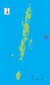
Outline map of the Andaman Islands, with the location of Barren Island highlighted (red circle)
-
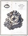
Topography of the island


