Bartlett Haystack facts for kids
Quick facts for kids Bartlett Haystack |
|
|---|---|

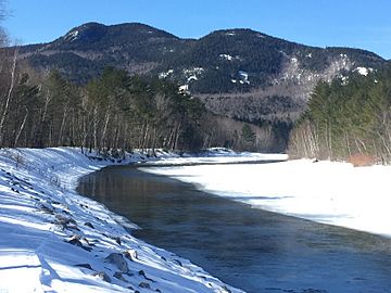
Bartlett Haystack rising above the Saco River
|
|
| Highest point | |
| Elevation | 2,995 feet (913 m) |
| Geography | |
| Location | Carroll County, NH |
| Topo map | USGS Bartlett |
Bartlett Haystack is a mountain found in Bartlett, New Hampshire. It's a cool place to explore in the White Mountains region.
Contents
About Bartlett Haystack Mountain
Bartlett Haystack is a mountain that stands 913 meters (about 2,995 feet) tall. It's located in the town of Bartlett, New Hampshire.
Who Was Josiah Bartlett?
The mountain and the town of Bartlett are both named after an important person named Dr. Josiah Bartlett (1729–1795). He was one of the people who signed the Declaration of Independence. This document announced that the United States was a free country. Josiah Bartlett also served as the sixth Governor of New Hampshire.
Mountains Nearby
Bartlett Haystack has other mountains close by. To its west, you'll find Mount Tremont. This mountain is taller, reaching about 1,027 meters (3,371 feet). To the southeast, across a place called Bear Notch, is Bear Mountain. It's about 981 meters (3,220 feet) high.
Water Around the Mountain
Bartlett Haystack is part of the watershed of the Saco River. A watershed is an area of land where all the water drains into one main river or body of water. The Saco River eventually flows into the Gulf of Maine, which is part of the Atlantic Ocean.
- Water from the east side of Bartlett Haystack flows into Albany Brook. This brook then joins the Saco River.
- Water from the north side goes into Stony Brook, another stream that feeds the Saco River.
- On the south side, water drains into Douglas Brook. This brook flows into the Swift River, which is also a part of the Saco River system.

