
Battle Road facts for kids

A section of the Battle Road
|
|
| Former name(s) | Old Concord Road Bay Road |
|---|---|
| Namesake | Battles of Lexington and Concord |
| Length | 18 mi (29 km) |
| Location | Concord, Massachusetts Lincoln, Massachusetts Lexington, Massachusetts |
| West end | Lexington Road and Old Bedford Road, Concord |
| East end | Wood Street, Lexington |
The Battle Road, also known as the Old Concord Road or the Bay Road, is a historic road in Massachusetts, United States. It was once the main road connecting Lexington, Lincoln, and Concord. These were important towns during the American Revolutionary War. On April 19, 1775, thousands of American colonists (called militia) and British soldiers (called redcoats) fought along Battle Road. This happened as the British retreated from Concord back to Boston.
Contents
The Battles of Lexington and Concord: A Historic Retreat
Why Did the British Retreat from Concord?
After fighting in Concord, Lieutenant Colonel Francis Smith was worried about his soldiers' safety. He sent groups of soldiers, called flankers, to walk along a ridge. Their job was to protect his main force from about 1,000 colonial militia who were now in the area.
As the British marched east out of Concord, this ridge ended near Meriam's Corner. This was a crossroads about a mile (2 km) from Concord village. The main road here crossed a small stream. To get over the narrow bridge, the British soldiers had to bring their flankers back into the main group. They had to march very close together, only three soldiers wide.
Colonial militia companies from the north and east had gathered at this spot. They now had more fighters than the British. The British were seeing what their general, Thomas Gage, had hoped to avoid. Thousands of colonial militiamen could quickly gather when British forces left Boston.
The Fight at Meriam's Corner
As the last British soldiers crossed the narrow bridge, the British rear guard turned and fired. They shot at the colonial militiamen. The colonists had been firing from a distance, but now they were much closer. The colonists fired back, and this time their shots were very effective. Two British soldiers were killed, and about six were wounded. No colonists were hurt. After crossing the bridge, Smith sent his flankers out again.
Battles Along the Road to Lexington
About a mile (1 km) past Meriam's Corner, on Brooks Hill, nearly 500 militiamen had gathered. They waited south of the road, ready to shoot down at the British soldiers below. Smith's leading soldiers charged up the hill to push them away. But the colonists did not leave. They caused many injuries to the British attackers. Smith pulled his men back from Brooks Hill. The British column then continued to another small bridge in Lincoln, at Brooks Tavern. Here, more militia companies attacked even harder from the north side of the road.

The British soldiers soon reached a place called the "Bloody Angle." Here, the road goes uphill and turns sharply left through a lightly wooded area. The militia from Woburn had placed themselves on the southeast side of this bend. Other militia, who had been fighting since Meriam's Corner, were on the northwest side. This trapped the British in a crossfire. Other militia companies on the road attacked from behind.
About 500 yards (450 m) further, the road took another sharp turn, this time to the right. Again, a large group of militiamen attacked the British column from both sides. As they passed through these two sharp turns, the British lost thirty soldiers who were killed or wounded. Four colonial militia were also killed. These included Captain Jonathan Wilson of Bedford, Captain Nathan Wyman of Billerica, Lt. John Bacon of Natick, and Daniel Thompson of Woburn. The British soldiers escaped by running. This was a pace the colonists could not keep up through the woods and swampy land. Colonial forces right behind the British were too crowded and disorganized to do more than bother them from the rear.
The British Face More Attacks
As more militia forces arrived from other towns, the colonial forces grew to about 2,000 men. The road now straightened to the east, with open fields and orchards on the sides. Lt. Col. Smith sent out flankers again. They managed to trap some militia from behind and cause injuries. British soldiers were also getting hurt from these fights and from constant long-range shooting by the militiamen. The tired British were running out of bullets.
.jpg)
When the British column got close to the border between Lincoln and Lexington, they faced another surprise attack. This was from a hill overlooking the road. Captain John Parker's Lexington militiamen, some of whom were bandaged from earlier fighting, had set this ambush. At this point, Lt. Col. Smith was shot in the thigh and fell from his horse. Major John Pitcairn took command of the column. He sent light infantry companies up the hill to clear out the militia.
The light infantry cleared two more hills as the column moved east—"The Bluff" and "Fiske Hill." They suffered even more injuries from ambushes set by new militia companies joining the battle. In one volley of musket fire from the colonial soldiers, Major Pitcairn's horse got scared and ran off. Pitcairn was thrown to the ground and hurt his arm. Now, both main leaders of the British group were injured or had lost their horses. Their men were tired, thirsty, and running out of ammunition. Some surrendered or were captured. Some even broke ranks and ran forward toward Lexington.
One British officer said, "we began to run rather than retreat in order... We tried to stop the men and form them two deep, but it was no use. The confusion grew instead of lessening... the officers got to the front and pointed their bayonets. They told the men if they went forward they would die. After this, they began to form up under heavy fire."
Only one British officer among the first three companies was not hurt as they neared Lexington Center. He understood how dangerous their situation was: "Very few men had any ammunition left. They were so tired that we could not keep flanking parties out. So we would soon have had to give up our weapons, or be shot by the Rebels whenever they wanted. We were not able to keep them off." Then he heard cheering ahead. A full brigade, about 1,000 men with cannons, led by Earl Percy, had arrived to save them. It was about 2:30 p.m., and the British column had been marching since 2 o'clock in the morning.
Rev. Joseph Thaxter, a Minuteman from Westford, wrote about what happened:
We chased them and killed some. When they got to Lexington, they were so closely chased and tired, that they would have soon given up. But Lord Percy met them with many more soldiers and two cannons. They fired them, but the balls went high over our heads. But no cannon ever did more damage. Such stories of their effects had been spread by the loyalists through our troops. From this time, more went back than chased. We chased to Charlestown Common, and then went back to Cambridge. When the army gathered at Cambridge, Colonel Prescott with his regiment of minute men, and John Robinson, his Lieutenant Colonel, were quick to be at their post.
New Ways of Fighting
Afterward, British officers and soldiers were frustrated. They said the colonial militiamen shot at them from behind trees and stone walls. They did not face them in large, straight lines like in European wars. This idea of the individual colonial farmer, fighting with his musket and on his own, has become a famous American story. "Chasing the red-coats down the lane / Then crossing the fields to emerge again / Under the trees at the turn of the road, / And only pausing to fire and load."
However, starting at the North Bridge and throughout the British retreat, the colonial militias often worked together as organized groups. They did this even when they spread out to use cover. Earl Percy thought about the British experience that day. He understood how important the American fighting style was:
During the whole event, the Rebels attacked us in a very spread out, unplanned way. But they did so with determination and courage. They never dared to form into any regular group. Indeed, they knew too well what was right to do. Anyone who sees them as an unplanned crowd will find themselves very wrong. They have men among them who know very well what they are doing. They have been used as Rangers against the Native Americans and Canadians. And this country, being very covered with wood and hilly, is very good for their way of fighting.
Exploring the Battle Road Trail Today

A five-mile (8 km) part of Battle Road became part of the Minute Man National Historical Park in 1959. This park is managed by the National Park Service. The park has a restored colonial landscape that looks like the path where the British and colonial militia fought. There's also a monument where Paul Revere was captured during his famous midnight ride. You can also see the Captain William Smith House and the Hartwell Tavern. The Hartwell Tavern is a restored 18th-century inn and house. Here, you can watch "living history" programs from May through October. You can get to the Battle Road Trail from several different parking areas.
In some places, the trail leaves the old historic road. This is so it can follow the path of the minutemen more closely. It crosses fields, wet areas, and goes through forests. The land in this area has gentle hills. The height above sea level changes from about 150 feet to 230 feet.
What Can You See on the Battle Road Trail?
The Battle Road is completely inside today's Minute Man National Historical Park. Here are some interesting places you can find along the road, listed from west to east. This matches the order of events on April 19, 1775.
Important Landmarks Along the Trail

- Meriam's Corner (Lexington Road and Old Bedford Road), Concord
This was the site of the first fight between the colonial militia and the British soldiers. The fighting continued for the next eighteen miles. (Around 12:30 PM)
-
- Grave of British soldiers
- Nathan Meriam House
- Lexington Road, Concord
- Route 2A (North Great Road), Lincoln
-
- Brooks Hill (Around 12:45 PM)
- Noah Brooks Tavern
- Job Brooks House
- Joshua Brooks House
- Route 2A (North Great Road) and Old Bedford Road, Lincoln
- The Bloody Angle (Around 1:00 PM)
- Grave of British soldiers
- Battle Road, Lincoln

-
- The Fight Through Lincoln (Around 1:10 PM)
- Hartwell Tavern
- Samuel Hartwell House (now in ruins)
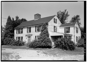
- Captain William Smith House
- Route 2A (North Great Road), Lincoln
.jpg)
-
- Grave of British soldiers
- Paul Revere capture site
- Battle Road, Lincoln
- Josiah Nelson House (now in ruins)
- Grave of British soldiers
- Thomas Nelson Jr. House (now in ruins)
- Airport Road, Lexington

-
- Tabitha Nelson House (now in ruins)
- Captain John Parker's Revenge (Around 1:30 PM)
- Jacob Whittemore House
- Route 2A (North Great Road) and Old Massachusetts Avenue, Lexington
- The Bluff (Around 1:35 PM)
- Old Massachusetts Avenue, Lexington
- Grave of British soldiers
- Battle at Fiske Hill (Around 1:40 PM)
- Grave of British soldiers
- Ebenezer Fiske House (only foundation parts remain)
