
Bayshore Cutoff facts for kids
Quick facts for kids Bayshore Cutoff |
|
|---|---|
.jpg)
Bayshore Highway crosses the Bayshore Cutoff at Tunnel 5, Sierra Point (c. 1915).
|
|
| Overview | |
| Other name(s) | Bay Shore Cut-Off |
| Status | Revenue service |
| Owner | Peninsula Corridor Joint Powers Board |
| Locale | San Francisco and northern San Mateo counties |
| Termini | San Francisco San Bruno |
| Stations | 7 (2 closed) |
| Service | |
| Type | Commuter rail, heavy rail |
| System | SP (Coast Line, Peninsula Commute; 1863–1992) Caltrain and Union Pacific (1992–present) |
| History | |
| Commenced | October 26, 1904 |
| Completed | December 8, 1907 |
| Technical | |
| Line length | 11.04 mi (17.77 km) |
| Number of tracks | 2 (4 in Brisbane after CTX) |
| Track gauge | 4 ft 8 1⁄2 in (1,435 mm) standard gauge |
| Electrification | planned, 25 kV AC |
| Operating speed | 79 mph (127 km/h) |
| Highest elevation | 20.3 ft (6.2 m) |
The Bayshore Cutoff is a special railway line. It connects San Francisco and San Bruno. This line runs along the eastern side of the San Francisco Peninsula.
The Southern Pacific (SP) company finished building it in 1907. It cost about $7 million, which was a lot of money back then. The line included five tunnels. Four of these tunnels are still used today by Caltrain. Caltrain is the train service that took over from Southern Pacific's old commuter line.
The dirt and rocks dug out from the tunnels were used for something important. They helped build the Visitacion or Bayshore Yard. This was a big train yard near Brisbane.
Before the Bayshore Cutoff, trains took a longer, harder route. That old route went around the western side of San Bruno Mountain. It passed through Colma and Daly City. Trains needed extra engines to get up the steep hills and around the sharp turns. This old route was nearly 13 miles long. The Bayshore Cutoff made the trip shorter, only about 10.5 miles. It also had much flatter tracks.
Once the Bayshore Cutoff was ready, most trains started using it. The old route was then called the Ocean View line. It became a smaller branch line. Later, parts of it were removed. In the 1980s, BART bought the land from the old Ocean View line. They used it to build the train extension to San Francisco International Airport.
One of the tunnels, Bayshore Cutoff Tunnel 5, is no longer used. It was closed in 1955-56. This happened when the Bayshore Freeway was built. The freeway needed the space where the tunnel was. The old train yard was used until the 1970s. Now, people are thinking about building new shops and businesses there.
Contents
How the Bayshore Cutoff Was Built

The first train tracks in this area were laid in 1863. They were built by the San Francisco and San Jose Railroad. This company later became part of Southern Pacific (SP). The original tracks went through the Mission District in San Francisco.
Southern Pacific took over the train service in 1870. They started looking for a better route as early as 1878. SP officially announced plans for the Bayshore Cutoff in 1901. They also planned to add a second track to the line.
Newspapers at the time were very excited about the Cutoff. They said it would save 15 minutes of travel time. This would make San Jose a more popular place to live.
The Bayshore Railway company was created to build the Cutoff. It was a part of Southern Pacific. Construction began in 1904 and finished in 1907. It was a very expensive project for its time. The Cutoff helped Southern Pacific fix three major traffic problems on their lines.
Trains immediately started using the new Bayshore Cutoff. They have used it ever since. Today, Caltrain runs daily commuter trains through four of these tunnels. The fifth tunnel at Sierra Point was closed around 1956. This happened when the Bayshore Freeway was built.
The old route west of San Bruno Mountain became less important. It was called the Ocean View line. The tracks were removed in 1942. Later, the land was sold to BART for their airport extension.

SP also built a large train yard at Visitacion, near Brisbane. They bought Visitacion Cove and filled it with dirt. This dirt came from the tunnels and from dredging the Bay. The yard was used to put trains together. It also had a big roundhouse and shops. These were used to fix steam locomotives.
After 1958, diesel engines replaced steam engines. The yard was used less often. SP moved its freight operations to Oakland in 1964. The Bayshore Yard started to be taken apart in 1979. The land was sold in 1989.
How the Line Was Designed
The Bayshore Cutoff has five tunnels. They are numbered from north to south. It also has the old Bayshore Yard near Brisbane. The historic Bayshore Roundhouse is still there. It was used to fix steam locomotives. The first four tunnels are in San Francisco.
The new line was much flatter than the old one. The highest point on the Bayshore Cutoff is only about 20 feet above sea level. The old route went up to 292 feet. The Cutoff is also shorter, about 11 miles long. This saved about 2.65 miles compared to the old route.
After the Cutoff was finished, train travel time was much faster. A trip from San Jose to San Francisco was cut from two hours to 90 minutes. For faster trains, it was only 70 minutes.
The Bayshore Cutoff has two tracks. But the land outside the tunnels is wide enough for four tracks. Extra tracks were added in Brisbane between 2004 and 2006. This was part of the Caltrain Express project.
Building the Tunnels
Work on the Bayshore Cutoff began in April 1904. An earthquake in November 1904 was at first confused with the blasting work. Workers in the tunnels were scared by the shaking from the big 1906 San Francisco earthquake. But no one was hurt, and the tunnels were not damaged. After the earthquake, construction continued. The rubble from the earthquake was even used to fill some areas, which helped speed up the work.
By July 1907, the Cutoff was almost finished. It was called "one of the fastest pieces of railroad in the United States."
-
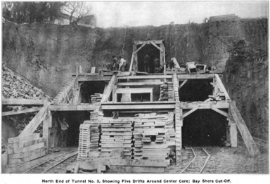
Five-drift tunnel construction (Tunnel No. 3)
-
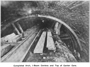
Brick arch in tunnel
-
Nearly complete tunnel, with steel arch forms
-
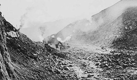
Steam shovel working in cut (1906)
-
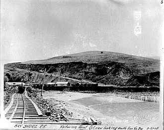
Cut at Visitacion Point (1905)
-
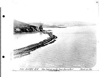
North from Sierra Point, prior to fill (1905)
-
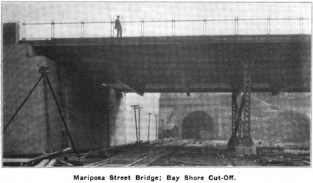
Bridge at Mariposa Street (1907)
-
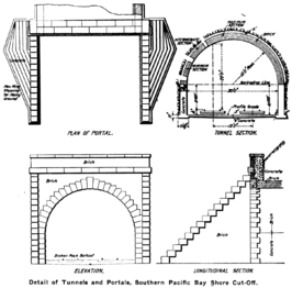
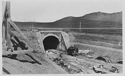
Tunnel and portal details (1904)
-
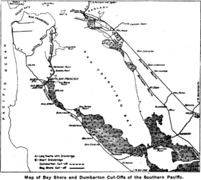
Map of Bayshore and Dumbarton Cut-Offs


.jpg)


The Tunnels Themselves
The five tunnels together are about 9,947 feet long. This is about one-fifth of the entire Bayshore Cutoff. Each tunnel is 30 feet wide. This allows for two tracks. The tunnels are about 27 feet high in the center.
Most tunnels were built by digging small tunnels first. Then, concrete walls were built. After that, a brick arch was added at the top. The space above the arch was filled with rock. Finally, the rest of the tunnel was cleared.
| No. | Length | Crosses | North portal | South Portal | Image |
|---|---|---|---|---|---|
| 1 | 1,817.3 ft | Potrero Hill | Mariposa St, between Pennsylvania & Indiana | 22nd St (Pennsylvania & Iowa) | .jpg) South portal (2010) |
| 2 | 1,086.4 ft | Potrero Hill | 23rd St (Pennsylvania & Indiana) | 25th St (Connecticut & Pennsylvania) |  North portal (2017) |
| 3 | 2,364 ft | Hunters Point | Palou Ave (Dunshee & Phelps) | Williams Ave (Diana & Reddy) |  South portal (c.1907) |
| 4 | 3,547 ft | Candlestick Point | Salinas Ave (Gould & Carr) | Blanken Ave (Bayshore & Tunnel) | .jpg) South portal (2012) |
| 5 | 1,133.8 ft | Sierra Point | between Van Waters & Rogers Rd and Bayshore Blvd | between Bayshore Blvd & US 101 (now filled) |  North portal (1908) |
Tunnels 1 and 2 are near the 22nd Street station. Tunnel 1 is north of it, and Tunnel 2 is south. Both go through Potrero Hill. Tunnel 2 was built to have four tracks, but only two are used now.
_(cropped).jpg)
Tunnel 3 goes through the Hunters Point area. It was built under an orphanage. The tracks are about 175 feet below the ground.
Tunnel 4 crosses Candlestick Point. The 1906 earthquake caused a spring to leak into Tunnel 4. This made the tunnel bulge, and water leaked in. The leak was finally fixed in 1911.
Tunnel 5 goes through Sierra Point. This tunnel was closed in 1956. This happened when the Bayshore Freeway was made bigger. The freeway needed the land where the tunnel was. The land around Sierra Point was leveled to help build the freeway. The southern entrance of Tunnel 5 is now filled in. The northern entrance still exists, but it is fenced off.
Bayshore Yard
.png)
- Cutoff
- Railyard
- Roundhouse

The dirt from digging the tunnels was used to create the new Bayshore Yard. This yard was built on land reclaimed from San Francisco Bay. Over 3 million cubic yards of dirt were used to create the yard. This included mud dredged from the Bay. Because it was built on reclaimed land, the buildings needed deep foundations. The land under the tracks also needed constant refilling for ten years.
The Bayshore Yard had about 50 to 65 miles of tracks. It was shaped like a triangle. It was bounded by the Bayshore Cutoff, the Bayshore Highway, and Tunnel 4. The yard was 8,400 feet long and 1,800 feet wide. By 1921, the Bayshore Yard was mostly complete.
The yard was designed with many tracks for freight trains. It could hold over 1,000 train cars. Southern Pacific moved all its freight and maintenance work to Bayshore Yard. Before this, they had two other locations. The yard also had a "hump" to help sort train cars. This was only the second one built on the West Coast.
.jpg)
At its busiest, between 1911 and 1958, over 3,000 people worked at the yard. In 1921, the yard handled 42,000 train cars each month. During World War II, it handled even more.
The land for the Bayshore Yard was sold in 1989. A company called Universal Paragon bought it. They have suggested building new things there. Today, only a few buildings from the old yard remain. These include the Roundhouse, the Tank and Boiler Shop, and the Ice Manufacturing Plant.
Bayshore Roundhouse
|
Southern Pacific Railroad Bayshore Roundhouse
|
|

Roundhouse in 2012
|
|
| Location | Jct. of Industrial Way and Bayshore Ave., Brisbane, California |
|---|---|
| Area | less than one acre |
| Built | 1910 |
| Built by | Southern Pacific Railroad |
| Architectural style | Industrial |
| NRHP reference No. | 10000113 |
| Added to NRHP | March 26, 2010 |
.jpg)
_(cropped).jpg)
The Southern Pacific Railroad Bayshore Roundhouse is a historic building. It is located in Brisbane, California. It was added to the National Register of Historic Places in 2010.
The Roundhouse was finished in 1910. It is still standing, even though a fire in 2001 damaged half its roof. It was one of the first buildings at the new Bayshore railyard.
The Roundhouse is shaped like a big arc. It has forty stalls for trains. Seventeen of these stalls were inside the building. The others were outside.
The Roundhouse had a turntable to turn locomotives around. It was 80 feet wide. In 1941, it was made bigger, to 110 feet. This allowed it to handle Southern Pacific's largest steam locomotives. The fire in 2001 destroyed the roof over some of the stalls. Today, it is the last brick roundhouse left in California.
Other Buildings
The Erecting and Machine Shops building was very large. It had 15 pits for engines. It also had big cranes. A scene from the movie Harold and Maude was filmed here. This building was torn down in the mid-1980s.
The Tank and Boiler Shops stopped being used when steam locomotives were replaced. It is now used as a charcoal warehouse.
Other buildings included a Locomotive Paint Shop and a Car Repair building.
The Visitacion Ice Manufacturing Plant was built in 1924. It made ice for Pacific Fruit Express refrigerated train cars. It could make 90 tons of ice per day. This building was sold in 1962.
Train Stations
Here are the stations along the Bayshore Cutoff, from north to south:
- San Francisco Third and Townsend (Closed in 1975)
- San Francisco 4th and King
- 22nd Street (between Tunnel 1 and Tunnel 2)
- Paul Avenue (Closed in 2005; between Tunnel 3 and Tunnel 4)
- Bayshore (between Tunnel 4 and Tunnel 5)
- Butler Road (Closed in 1983)
- South San Francisco
- San Bruno
