
Beacon Hill, Warnford facts for kids
| Site of Special Scientific Interest | |
| Area of Search | Hampshire |
|---|---|
| Interest | Biological |
| Area | 46.4 hectares (115 acres) |
| Notification | 1984 |
| Location map | Magic Map |
Beacon Hill, Warnford, is a special place in Hampshire, England. It's one of two hills named Beacon Hill in the area. This particular hill is a Site of Special Scientific Interest (SSSI), which means it's protected for its amazing wildlife and natural features. It covers about 46.4 hectares (that's like 115 football fields!).
A big part of the hill, about 40.1 hectares, is also a National Nature Reserve. This means it's a place where nature is carefully looked after. On top of that, there's an ancient burial ground here. It has round barrows (old burial mounds) from the Late Neolithic or Bronze Age periods. This makes it a Scheduled Monument, protecting its historical importance.
Contents
Where is Beacon Hill Located?
Beacon Hill is found west of the Meon Valley, right across from another famous spot called Old Winchester Hill. From its top, you can see far across the Hampshire Basin to the south. You might even spot the New Forest, the Solent, and the Isle of Wight. On a clear day, you can see Portsdown Hill and even the top of Portsmouth's Spinnaker Tower.
Looking west, you'll see the Meon Valley, including villages like Meonstoke and West Meon. You can also see parts of the South Downs, like Old Winchester Hill and Butser Hill. To the north, the spire of Privett church stands out.
Two long walking trails cross Beacon Hill. These are the South Downs Way and the Monarch's Way. Because the soil on the hill is very delicate, the paths sometimes have temporary routes. These temporary paths go north through Warnford or south through Exton.
Why is Beacon Hill a Special Scientific Site?
Beacon Hill is a Site of Special Scientific Interest (SSSI) because of its unique natural environment. The hill has steep slopes made of chalk on the western side of the Meon valley. These slopes are covered with different types of plants and trees. You'll find chalk grassland, woodlands with beech, ash, and hazel trees, and areas of chalk scrub.
The SSSI is split into two separate parts. The main section includes two areas:
- About 16.2 hectares of "Beaconhill Beeches," which is a mixed forest with broadleaf trees and yew.
- About 23.54 hectares of beautiful chalk grassland.
The smaller, northern part of the SSSI is a strip of grassland on a north-facing slope.
Amazing Grassland Plants
The grassland here is home to many interesting plants. The most common ones are sheep's fescue, salad burnet, and common rock-rose. You can also find horseshoe vetch, yellow-wort, fragrant orchid, and clustered bellflower.
Even rarer plants grow here, too! These include rampion, field fleawort, hairy rock-cress, and man orchid.
Butterflies Galore!
Beacon Hill is also famous for its butterflies. Experts have found that 25 different types of butterflies breed here. Some of the special ones include the silver-spotted skipper and the Duke of Burgundy. There are also many brown argus, green hairstreak, chalkhill blue, marbled white, and dingy skipper butterflies. It's a fantastic place for butterfly watching!
How Beacon Hill Was Formed
Beacon Hill's shape and rocks tell a story about how the land changed over millions of years.
The Hill's Structure
Beacon Hill is part of a large fold in the Earth's crust called an anticline. This fold, known as the Winchester-East Meon Anticline, runs from east to west. Rivers like the Meon have cut through this fold, showing older layers of chalk rock. Beacon Hill and Old Winchester Hill are parts of this folded chalk. Beacon Hill is about 201 meters (659 feet) high, and Old Winchester Hill is a bit taller at 212 meters (696 feet).
How the Landscape Changed
Beacon Hill is a section of an east-facing escarpment, which is a steep slope. Both Beacon Hill and Old Winchester Hill are important for understanding the South Downs. They show where the main north-facing slope of the South Downs turns north.
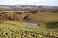
The hill has many deep, bowl-shaped valleys called combes on its eastern side. There are also deep dry valleys to the south and west. Several roads and paths meet near the summit, running along the spurs (ridges) between these valleys.
Images for kids
-
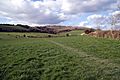
The south eastern combe from the South Downs Way above Exton.
-
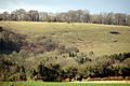
The back of the south eastern combe.
-
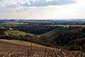
The Punchbowl, on the southern side, with view to Isle of Wight.
-
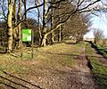
Beaconhill Beeches, part of the SSSI and NNR.
-
A combe on the eastern side, looking across the Meon Valley to Old Winchester Hill.
