
Portsdown Hill facts for kids
Quick facts for kids Portsdown Hill |
|
|---|---|

Portsdown Hill Area, Portsmouth North
|
|
| Highest point | |
| Elevation | 131 m (430 ft) |
| Listing | County Top |
| Geography | |
| Location | Hampshire, England |
| OS grid | SU627069 |
| Topo map | OS Landranger 196 |
Portsdown Hill is a long ridge made of chalk in Hampshire, England. The highest part of the hill is inside Fort Southwick. It is 131 meters (about 430 feet) above sea level. From the hill, you can see great views to the south. You can see Portsmouth, the Solent (a strait), Hayling Island, and Gosport. Beyond them, you can see the Isle of Wight.
The hill is on the mainland. It is just north of Ports Creek. This creek separates the mainland from Portsea Island. Most of Portsmouth, a big naval base, is on Portsea Island. To the north of the hill is the Forest of Bere. You can also see the South Downs far away. On a clear day, you might even spot Butser Hill. The hill is made of chalk that was pushed up by natural forces. This happened because of a fold in the earth called the Portsdown Anticline.
Southwick House is near the north side of the hill. This house was the main office for U.S. General Dwight D. Eisenhower during the D-Day invasions. Before D-Day, the generals prayed at Christ Church Portsdown, which is on the hill. This church has a special window to remember them. The A3(M) motorway goes through the east side of the hill. The older A3 road goes over the middle, near the George Inn pub and Christ Church. The closest train stations are Portchester, Cosham, and Bedhampton. Many stories are told about real and imagined tunnels inside the hill.
The area also has places where military research happens. These include a main site for Dstl (called Dstl Portsdown West) and sites run by QinetiQ. A part of the hill is a special nature area called a Site of Special Scientific Interest. Most of the southern side of the hill is open to the public. People can walk and enjoy the views there.
During the early part of the English Civil War, soldiers from Portsmouth fought battles on the hill. These were between the Royalist forces and the Parliamentarians. In the Victorian era, Portsdown Hill was famous for a big fair held every Easter Monday.
Contents
Portsdown Forts: Protecting Portsmouth
The forts on Portsdown Hill were built a long time ago. They were made after a special report in 1859. These forts were part of many fortifications built to protect Portsmouth and its dockyard. The dockyard is about 8 kilometers (5 miles) away.
The forts were built to stop an attack from inland. At that time, new types of guns could shoot very far. An enemy army could land somewhere else, go around, and then shoot at Portsmouth from the top of the hill. This would make the old defenses at Hilsea useless. So, six forts were planned along the 10-kilometer (6-mile) ridge. From west to east, they are Fort Fareham, Fort Wallington, Fort Nelson, Fort Southwick, Fort Widley, and Fort Purbrook. Two smaller forts, Crookhorn Redoubt and Farlington Redoubt, finished the line at the eastern end.
People thought the main threat was from Napoléon III of France. But this danger went away soon after the forts were finished. Because of this, the forts became known as "Palmerston's Folly" (meaning a silly idea). Even though they were never used for their first purpose, they were very helpful. They were used as anti-aircraft gun positions during World War II.
Exploring the Forts Today
- Fort Fareham is now a small industrial area. Parts of the fort are still standing and are protected as a Grade II listed building.
- Fort Wallington has mostly been taken down to make way for an industrial estate. What is left is also a protected Grade II listed building.
- Fort Nelson has been greatly repaired. It is now an artillery museum run by the Royal Armouries. It is a Grade I listed building, which is the highest level of protection.
- Fort Southwick was a military research place for many years. It was sold in 2003 for homes. It is also a Grade I listed building.
- Fort Widley is owned by Portsmouth council. It has horse stables and rooms for community events. You can take tours on summer weekends. It is a Grade II* listed building.
- Fort Purbrook sometimes opens for craft fairs. It also has an activity center where you can try archery, rifle shooting, and indoor rock-climbing. It is a Grade II* listed building.
The Crookhorn Redoubt, which guarded Fort Purbrook, started to sink and was taken down by 1876. The Farlington Redoubt only had its ditches and gun positions dug. It was finally taken down in the 1970s. A tunnel between Crookhorn and Purbrook has been found again.
Portsdown also gave its name to a military area in Singapore. Even after the British army left in 1967, the Portsdown estate is still active. Portsdown Road is the main road running through it.
Portsdown SSSI: A Special Natural Area
Over fifty hectares (about 123 acres) on the south side of Portsdown Hill are a Site of Special Scientific Interest (SSSI). This is because of its special chalk grassland habitat. Animals stopped grazing here in the early 1950s. Because of this, the area slowly became covered with bushes. These were mostly hawthorn, dogwood, and wild privet.
In 1995, a big project started to restore the area. This project was paid for by the Countryside Commission and Portsmouth City Council. Large areas of bushes have now been cleared by machines. This has allowed flowers and grasses to grow back naturally. To stop the bushes from growing back, cattle and horses graze there in the winter.
Some types of butterflies disappeared because their habitat was lost to the bushes. These included the Adonis blue, silver-studded blue, dingy skipper, and dark green fritillary. Other butterflies, like the chalkhill blue and small blue, were almost gone. But now they are doing well again. In fact, Portsdown Hill probably has the largest group of small blue butterflies in the UK.
Images for kids
-
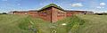
Part of the defenses of Fort Nelson
-
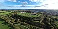
Fort Widley from the North, with Portsmouth, Isle of Wight, and Solent
-
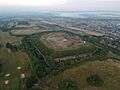
Fort Purbrook, Portsdown Hill, Portsmouth
-
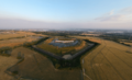
Fort Nelson, Portsdown Hill, viewed from the south


