Bear Peak (Boulder County, Colorado) facts for kids
Quick facts for kids Bear Peak |
|
|---|---|

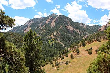
Bear Peak viewed from the NCAR Trail
|
|
| Highest point | |
| Elevation | 8,459 ft (2,578 m) |
| Prominence | 281 ft (86 m) |
| Isolation | 0.50 mi (0.80 km) |
| Geography | |
| Location | Boulder County, Colorado, U.S. |
| Parent range | Front Range |
| Topo map | USGS 7.5' topographic map Eldorado Springs, Colorado |
| Climbing | |
| Easiest route | hike |
Bear Peak is a tall mountain in the Front Range of the Rocky Mountains in North America. This peak stands at 8,459-foot (2,578 m) high. It is located in Boulder Mountain Park, about 5.2 miles (8.3 km) south of downtown Boulder. You can find it in Boulder County, Colorado, United States.
Contents
Discovering Bear Peak
Bear Peak is a well-known mountain that marks the southern end of Boulder's famous Flatirons. The Flatirons are large, slanted rock formations that stand out on the western side of the city. Hiking to the very top of Bear Peak is a very popular activity for many people.
Activities on Bear Peak
Besides hiking, Bear Peak is also a great spot for rock climbing. There are at least three main rock climbing areas right next to the peak. These spots are called The Slab, The Goose, and Seal Rock.
Rock Climbing Challenges
The rock climbs on Bear Peak range from easy to very difficult. Climbs are rated using a special system. A 5.2 rating means the climb is quite easy, perfect for beginners. A 5.13 rating means the climb is very challenging and only for experienced climbers.
Wildfires and Bear Peak
On June 26, 2012, a wildfire called the Flagstaff Fire started near Bear Peak. This fire burned a part of the upper section of the mountain. Some homes in south Boulder had to be evacuated to keep people safe. Luckily, no buildings were destroyed by the fire. The Flagstaff Fire was one of many fires that happened during a busy fire season in Colorado that year.
 | James B. Knighten |
 | Azellia White |
 | Willa Brown |


