
Beast Cliff facts for kids
Quick facts for kids Beast Cliff |
|
|---|---|
.jpg)
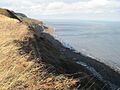
Looking north along Beast Cliff showing the intermediate plateau aligned with the horizon (2012)
|
|

Location in England
|
|
| OS grid | TA0099 |
| Coordinates | 54°22′50″N 0°27′34″W / 54.380501°N 0.459452°W |
| Topo map | OS Explorer OL27 |
Beast Cliff is a very steep cliff by the sea in North Yorkshire, England. It's located about halfway between the towns of Whitby and Scarborough. This area is super important for nature, so it's protected as a Special Area of Conservation and a Site of Special Scientific Interest. The famous Cleveland Way walking path runs right along the top of these cliffs.
Contents
Exploring Beast Cliff
.jpg)

Beast Cliff is made of ancient rocks like Jurassic sandstone and shale. It's covered in lots of plants and trees. Partway down the main cliff, there's a gently sloping area called an intermediate plateau where scrub and woodland grow. This plateau separates the lower and upper parts of the cliff.
The lower part of the cliff is about 45 meters (148 feet) high. It has two steep slopes with a nearly vertical section in between. The upper cliff is about 75 meters (246 feet) high and slopes at about 45 degrees. In total, Beast Cliff stands about 160 meters (525 feet) tall!
The cliffs are always changing because of landslides. This means the woodland is constantly growing new, young trees. You can see mosses and ferns covering the sandstone rocks. The forest is full of young ash and birch trees, with alder and willow growing near small pools of water.
The Cleveland Way is a long-distance walking path that follows the top of the cliffs. Long ago, people used to lower animals down on ropes to the intermediate plateau so they could graze there.
This whole coastline, from Maw Wyke to Beast Cliff near Robin Hood's Bay, is a special protected area. It's known as a Site of Special Scientific Interest because its coastal and woodland plants are nationally important. Part of the area is also a Special Area of Conservation, called "Beast Cliff–Whitby (Robin Hood's Bay)". These protections help keep the area natural and allow its unique geology and plants to thrive.
In 1923, a fishing boat called the FV Premier got stuck near the cliffs. The lifeboat from Robin Hood's Bay bravely rescued all nine crew members. Sadly, the boat later broke apart in the rough seas at the bottom of Beast Cliff.
A Unique Spot on the Map

Beast Cliff holds a special secret when it comes to maps! The British Ordnance Survey National Grid is a system that uses letters and numbers to pinpoint locations. Imagine the whole country divided into huge squares.
The OV0000 Square

At the northern end of Beast Cliff, there's a one-kilometer square on the map known as OV0000. This square is super unique! It's the only piece of land in a much larger 100-kilometer by 100-kilometer square, which is also labeled OV. All the other parts of this big OV square are covered by the North Sea.
This means OV0000 is the only land in the entire 500-kilometer square that starts with the letter 'O' in the British grid system. It's a tiny bit of land surrounded by a lot of ocean!
Geograph Project and OV0000
The Geograph Britain and Ireland project aims to take a photo of every one-kilometer square of land in Great Britain. They have a fun competition to see who can upload the first photo for each square.
When the first photo of OV0000 was uploaded in 2006, it set a new record! Since OV0000 was the only land square in its huge 100-kilometer "myriad" (as Geograph calls them), it became the first "myriad" to have all its land squares photographed. It was a big win for the project!
Only a very small part of OV0000 is actually land, mostly just the foreshore at the very bottom of the cliff.
Amateur Radio and OV00


There's a group called Worked All Britain for amateur radio enthusiasts. They give awards to people who can operate their radio stations from as many different 100-kilometer map squares as possible.
The first time someone operated a radio from the OV00 square was on September 8, 1977. In 1987, a special ladder was even built on the steepest part of Beast Cliff to help radio operators get down to the intermediate plateau. They used ropes to get to the ladder and then more ropes to reach the shore. An 8-meter (26-foot) radio mast was set up on a tree trunk. However, big storms in 1999 destroyed everything. A new route was built in 2006 for people to access this unique spot.
Images for kids
-
Looking north along Beast Cliff showing the intermediate plateau aligned with the horizon (2012)
