
Robin Hood's Bay facts for kids
Quick facts for kids Robin Hood's Bay |
|
|---|---|
 Robin Hood's Bay |
|

Robin Hood's Bay
|
|
| OS grid reference | NZ950053 |
| Civil parish |
|
| Unitary authority |
|
| Ceremonial county | |
| Region | |
| Country | England |
| Sovereign state | United Kingdom |
| Post town | Whitby |
| Postcode district | YO22 |
| Dialling code | 01947 |
| Police | North Yorkshire |
| Fire | North Yorkshire |
| Ambulance | Yorkshire |
| EU Parliament | Yorkshire and the Humber |
| UK Parliament |
|
Robin Hood's Bay is a charming village located in North Yorkshire, England. It sits right on the beautiful Yorkshire Coast, about 6 miles (10 km) south of Whitby and 15 miles (24 km) north of Scarborough.
This historic village is part of the area called Fylingdales. It's also a popular spot for hikers, as it's on the Cleveland Way national trail. Plus, it's the end point of Wainwright's famous Coast to Coast Walk, a long journey across England!
Contents
History of Robin Hood's Bay
_(LOC)_(16180464504).jpg)
How Robin Hood's Bay Got Its Name
The name "Robin Hood's Bay" is a bit of a mystery! It's unlikely that the famous Robin Hood ever actually visited this area. The name "Robyn Hoodis Baye" was first recorded in 1544.
There's an old English song called The Noble Fisherman that tells a story. In it, Robin Hood visits Scarborough, becomes a fisherman, and defeats French pirates. He then uses his treasure to build homes for the poor. However, this song was written much later, in the 1600s, and probably isn't based on a real event. It's more likely that the writer knew of Robin Hood's Bay and wanted to connect their story to the area.
Early Days of the Village
Around the year 1000, nearby areas like Raw and Thorpe (Fylingthorpe) were settled by people from Norway and Denmark. After the Norman conquest in 1069, much of this land was left empty. Later, William the Conqueror gave Fylingdales to Tancred the Fleming, who then sold it to the Abbot of Whitby.
The first mention of Robin Hood's Bay itself was between 1324 and 1346. A letter from Louis I, Count of Flanders, complained to King Edward III that Flemish fishermen were being taken by force to "Robyn Oeds Bay."
By the 1500s, a settlement had grown right on the coast. In 1536, a writer named Leland described "Robin Hoode Baye" as a "fishing village of 20 boats." After the monasteries were closed down in 1540, Whitby Abbey and its lands became the property of King Henry VIII. You can still see names like King Street and King's Beck from this time.
In the 16th century, Robin Hood's Bay was actually a more important port than Whitby! Old maps from 1586 even show tiny pictures of tall houses and an anchor for the bay.
Smuggling Secrets

Robin Hood's Bay is famous for its history of smuggling. The village has a maze of tiny, winding streets. People say there are secret underground passages connecting the houses!
In the late 1700s, smuggling was very common along the Yorkshire coast. Ships from other countries would bring illegal goods like tea, gin, rum, brandy, and tobacco. These items were smuggled in from the Netherlands and France to avoid paying taxes. Local groups would then distribute them.
There were even battles between smugglers and the "excise men" (officials who collected taxes). In 1773, two excise boats were outgunned and chased away by three smuggling vessels. In 1779, a big fight happened in the dock over 200 barrels of brandy and gin, and 15 bags of tea!
Fishing, Farming, and Brave Lifeboats

For many years, fishing and farming were the main jobs for families in Robin Hood's Bay. Many houses built between 1650 and 1750 were home to families involved in fishing. They often owned or partly owned small fishing boats called cobles.
Fishing was busiest in the mid-1800s. Fishermen used cobles for line fishing in winter and larger boats for catching herring. The fish were loaded into baskets, and people would walk or ride across the moorland paths to sell them in towns like Pickering or York.
A special plaque in the village tells a heroic story from 1881. A ship called "Visiter" got stuck in Robin Hood's Bay during a terrible storm. To save the crew, the lifeboat from Whitby had to be pulled 6 miles (10 km) overland! It took 18 horses and 200 men to clear 7-foot (2.1 m) deep snowdrifts. The road into the village was so narrow and twisty that men had to knock down garden walls and pull up bushes to make way for the lifeboat. The crew of the "Visiter" was rescued after two attempts.
Today, fishing is not as big as it used to be. Most of the village's money now comes from visitors who come to enjoy its beauty.
Fossils and Marine Life
Robin Hood's Bay is also well-known for the many fossils you can find on its beach. The rocks on the north side of the bay are especially good for finding ammonites (ancient sea creatures that look like coiled shells), especially after winter storms.
From 1912 to 1983, a place called the Robin Hood's Bay Marine Laboratory operated here. Scientists from Leeds University and the University of Sheffield studied sea life there for over 70 years.
Geography of Robin Hood's Bay
.jpg)
Robin Hood's Bay is built in a natural crack between two steep cliffs. The village houses are mostly made of sandstone with red-tiled roofs, giving them a unique look.
The main street, called New Road, winds down from the top of the cliff. At the top, you'll find the manor house, newer homes, and St Stephen's Church, Fylingdales. The road goes through the village, crosses a small stream called King's Beck, and finally reaches the beach by a cobbled path known as Wayfoot. The stream then flows out onto the beach.
The cliffs around the bay are made up of different types of rock, including shales and sandstones. The area is also important for geologists because a specific rock layer near Robin Hood's Bay helps define a period in Earth's history called the Pliensbachian Epoch, which was about 183 to 189 million years ago!
The two rocky points at each end of the beach are called Ness Point (to the north) and Old Peak (to the south).
Getting Around Robin Hood's Bay
The village once had its own train station on the Scarborough and Whitby Railway line, which opened in 1885. However, the railway closed in 1965. The old train tracks are now a popular path for walking and cycling. The closest working train station is in Whitby.
You can reach the village by car using the A171, which connects to Whitby and Scarborough. There's also a bus service, the X93 Arriva bus, that runs between Scarborough and Middlesbrough and stops in Robin Hood's Bay every hour (or more often in summer).
As mentioned, Robin Hood's Bay is the end point of Wainwright's famous Coast to Coast Walk. It's also part of the Cleveland Way, another long-distance walking path along the coast.
Churches in Fylingdales
.jpg)
Robin Hood's Bay is part of the Fylingdales area, which has two churches, both named St Stephen's. The Old St Stephen's Church, Fylingdales is on the hillside at Raw, above the village. This church replaced a very old one that had Saxon origins.
A newer church, also called St Stephen's, was built in 1870. It was designed by a famous architect named George Edmund Street.
Culture and Fun Facts

Robin Hood's Bay has appeared in books and movies!
- The famous novel Dracula by Bram Stoker, written in 1897, has parts set in Robin Hood's Bay. The author visited the area and used its steep paths and dramatic coastline in his story, including the ship that runs aground and the mysterious dog (which is Dracula himself!).
- The village is also the setting for the Bramblewick novels by Leo Walmsley (1892–1966). He even went to school in the old Wesleyan Chapel in the lower village. The 1935 film Turn of the Tide was filmed here and was based on one of his books.
- In 1925, a group of artists called the Fylingdales Group of Artists was started in Robin Hood's Bay.
- The 2008 movie Wild Child and the 2017 film Phantom Thread (starring Daniel Day-Lewis) both filmed scenes in Robin Hood's Bay, including the inside of the Victoria Hotel and the cliffs.
- "Missing in Time," a novel by Catherine Harriott, is set in the village and talks about its history and culture.
- There's even a poem called "Robin Hood's Bay" by children's poet Michael Rosen.
The local newspaper, Bayfair, shares news and information about the village. Visitors can also get internet access through the Bay Broadband Co-operative.
Local Media
If you're in Robin Hood's Bay, you can get local news and TV shows from BBC North East and Cumbria and ITV Tyne Tees.
Local radio stations include BBC Radio Tees, BBC Radio York, Greatest Hits Radio Yorkshire Coast, Coast & County Radio, and This is The Coast.
The village is also served by local newspapers like the Whitby Gazette and the Evening Gazette.
Famous People From Robin Hood's Bay
Some notable people have connections to Robin Hood's Bay:
- Eileen Colwell, a librarian, was born here.
- Steve Huison, an actor known for "The Full Monty," has lived in the village.
- Leo Walmsley, the author, lived in the village between 1894 and 1913.
Images for kids
-
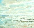
Robin Hood's Bay by Dame Ethel Walker, Aberdeen Art Gallery
-
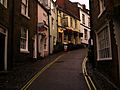
King Street in Robin Hood's Bay
-
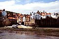
Robin Hood's Bay - view from the sea
-
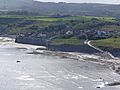
Robin Hood's Bay from the Cleveland Way
-
Morris Dancers in Robin Hood's Bay
-

Robin Hood's Bay Sculpture


See also
 In Spanish: Bahía de Robin Hood para niños
