Beatriz, Caguas, Puerto Rico facts for kids
Quick facts for kids
Beatriz
|
|
|---|---|
|
Barrio
|
|

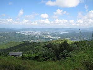
View of Caguas from Cerro Las Piñas in Beatriz
|
|

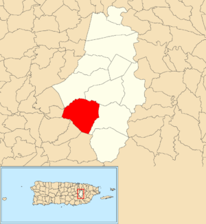
Location of Beatriz within the municipality of Caguas shown in red
|
|
| Commonwealth | |
| Municipality | |
| Area | |
| • Total | 6.13 sq mi (15.9 km2) |
| • Land | 6.13 sq mi (15.9 km2) |
| • Water | 0.00 sq mi (0 km2) |
| Elevation | 725 ft (221 m) |
| Population
(2010)
|
|
| • Total | 4,353 |
| • Density | 710.1/sq mi (274.2/km2) |
| Source: 2010 Census | |
| Time zone | UTC−4 (AST) |
Beatriz is a special area called a barrio in the city of Caguas, Puerto Rico. In 2010, about 4,353 people lived there.
Contents
Geography of Beatriz
Beatriz is located at these coordinates: 18°10′23″N 66°4′37″W / 18.17306°N 66.07694°W. It covers about 15.89 square kilometers (6.13 square miles) of land. Almost all of this area is land, with very little water.
This barrio is found in the Sierra de Cayey mountains. This mountain range is part of the larger Cordillera Central. Because of its location, Beatriz is different from other parts of Caguas. Most of Caguas is in a valley, but Beatriz is up in the mountains. The name Beatriz comes from the Doña Beatriz Creek. This creek flows through the area and into the Turabo River.
Communities and People
Barrios are like small towns or neighborhoods within a larger city. They are often divided into even smaller areas called sectores (which means "sectors" in English). These sectors can have different names like urbanización or reparto.
Here are some of the sectors you can find in Beatriz:
- Alturas de Beatriz
- Alturas de Caguas (Beatriz)
- Barrio Beatriz
- Colinas de Villa Coquí
- La Jurado
- Las Abejas
- Los Ortíz
- Los Panes
- Muñoz Grillo
- Piñas I
- Piñas II
- Piñas III
- Villa Paolo
In 2010, the population of Beatriz was 4,353 people. This means there were about 27,391 people living per square kilometer. Most of the people living in Beatriz were of Hispanic or Latino background, making up about 99.47% of the population.
| Historical population | |||
|---|---|---|---|
| Census | Pop. | %± | |
| 1900 | 868 | — | |
| 1950 | 2,713 | — | |
| 1980 | 3,543 | — | |
| 1990 | 3,807 | 7.5% | |
| 2000 | 4,467 | 17.3% | |
| 2010 | 4,353 | −2.6% | |
| U.S. Decennial Census 1899 (shown as 1900) 1910-1930 1930-1950 1980-2000 2010 |
|||
History of Beatriz
Puerto Rico became a territory of the United States after the Spanish–American War. This happened in 1898, following the Treaty of Paris of 1898. In 1899, the United States government counted the people in Puerto Rico. They found that 868 people lived in Beatriz barrio at that time.
During the 1800s, Beatriz was mostly made up of small farms. People grew food to feed their families. A scientist named William Edwin Safford visited Beatriz in 1898. He came to study and record the different plants growing in the area.
In 1899, a very strong storm called the 1899 San Ciriaco hurricane hit Beatriz. It caused a lot of damage. After the hurricane, many farmers started working for the new United States government. They helped build roads to fix the damage. At that time, a store owned by a rich landowner, Don Ramón Álvarez, was very important for the local economy. In 1900, one of his cashiers, Don Demetrio López, was chosen to be the local leader, or alcalde, of Beatriz.
More recently, Hurricane Maria hit Beatriz on September 20, 2017. Many homes lost electricity. Some residents still did not have power even six months later, in March 2018.
Cool Places to Visit
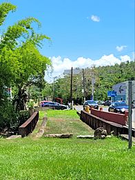
- Carretera Central: This is a very old and important road. It connects the city of San Juan in the north to Ponce in the south. This historic road goes right through Beatriz.
- Centro Los Panes: This is a community center. It's a place where people can gather and do activities. It's located near the La Jurado sector.
- Cerro Las Piñas: This is a hill that sits on the border of Beatriz and Beatriz, Cayey. From the top, you can see amazing views of the Caguas Valley and the mountains around it.
See also
 In Spanish: Beatriz (Caguas) para niños
- List of communities in Puerto Rico


