Bel Air North, Maryland facts for kids
Quick facts for kids
Bel Air North, Maryland
|
|
|---|---|

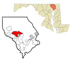
Location of Bel Air North, Maryland
|
|
| Country | United States |
| State | Maryland |
| County | Harford |
| Area | |
| • Total | 16.04 sq mi (41.55 km2) |
| • Land | 15.97 sq mi (41.36 km2) |
| • Water | 0.07 sq mi (0.20 km2) |
| Elevation | 460 ft (140 m) |
| Population
(2020)
|
|
| • Total | 31,841 |
| • Density | 1,994.05/sq mi (769.93/km2) |
| Time zone | UTC−5 (Eastern (EST)) |
| • Summer (DST) | UTC−4 (EDT) |
| FIPS code | 24-05825 |
Bel Air North is a special kind of community in Harford County, Maryland, United States. It's called a census-designated place (CDP). This means it's an area that the government counts for population, but it's not an official town or city with its own local government.
Bel Air North is located right next to the town of Bel Air, just to its north. In 2020, about 31,841 people lived here. This was an increase from 25,798 people in 2000.
Where is Bel Air North?
Bel Air North is in the western-central part of Harford County. You can find its center at 39°33′2″N 76°21′42″W / 39.55056°N 76.36167°W.
It shares borders with a few other places:
- To the south, it borders the town of Bel Air and another CDP called Bel Air South.
- To the southwest, it borders Fallston.
Some roads and natural features help mark its boundaries:
- Maryland Route 23 and Prospect Mill Road form the northern border.
- East of Bel Air, Maryland Route 22 (Churchville Road) separates Bel Air North from Bel Air South.
- West of Bel Air, Baltimore Pike does the same job.
- Winters Run is a stream that forms the southwest border, separating Bel Air North from Fallston.
U.S. Route 1 goes through the middle of Bel Air North. This major road goes around Bel Air to the north. If you follow Route 1 northeast for about 13 miles (21 km), you'll reach the Conowingo Dam on the Susquehanna River. If you go southwest for about 23 miles (37 km), you'll arrive in Baltimore.
The United States Census Bureau says that Bel Air North covers a total area of about 16.1 square miles (41.8 km2). Most of this area, about 16.1 square miles (41.6 km2), is land. A small part, about 0.1 square miles (0.2 km2), is water.
How Many People Live Here?
Bel Air North has grown quite a bit over the years. Here's how its population has changed:
| Historical population | |||
|---|---|---|---|
| Census | Pop. | %± | |
| 1970 | 2,771 | — | |
| 1980 | 5,043 | 82.0% | |
| 1990 | 14,880 | 195.1% | |
| 2000 | 25,798 | 73.4% | |
| 2010 | 30,568 | 18.5% | |
| 2020 | 31,841 | 4.2% | |
| source: | |||
Based on the census from 2000, there were 25,798 people living in Bel Air North. There were 8,716 households, which are groups of people living together in one home. Most of these households, 7,190, were families.
The people living in Bel Air North come from different backgrounds. In 2000, most residents were White (about 95%). There were also African American (about 2.2%), Asian (about 1.6%), and Native American (about 0.1%) residents. Some people identified with two or more races, and a small number were from other racial groups. About 1.1% of the population was Hispanic or Latino.
Many homes in Bel Air North have children. In 2000, about 48% of households had children under 18 living with them. Most households (72%) were married couples living together.
The population in Bel Air North is spread across different age groups:
- About 31% of the people were under 18 years old.
- About 32% were between 25 and 44 years old.
- About 22% were between 45 and 64 years old.
- About 8% were 65 years old or older.
The average age of people in Bel Air North was 35 years.
See also
 In Spanish: Bel Air North (Maryland) para niños
 | Stephanie Wilson |
 | Charles Bolden |
 | Ronald McNair |
 | Frederick D. Gregory |

