Belle, Missouri facts for kids
Quick facts for kids
Belle, Missouri
|
|
|---|---|

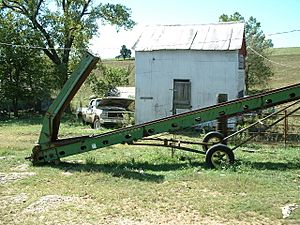
Grain conveyor on a farm near Belle
|
|

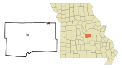
Location in Maries County and the state of Missouri
|
|
| Country | United States |
| State | Missouri |
| Counties | Maries, Osage |
| Incorporated | 1895 |
| Area | |
| • Total | 1.34 sq mi (3.46 km2) |
| • Land | 1.33 sq mi (3.46 km2) |
| • Water | 0.00 sq mi (0.00 km2) |
| Elevation | 1,024 ft (312 m) |
| Population
(2020)
|
|
| • Total | 1,381 |
| • Density | 1,034.46/sq mi (399.48/km2) |
| Time zone | UTC-6 (Central (CST)) |
| • Summer (DST) | UTC-5 (CDT) |
| ZIP code |
65013
|
| Area code(s) | 573 |
| FIPS code | 29-04150 |
| GNIS feature ID | 2394112 |
Belle is a small city located in the state of Missouri, USA. It sits partly in Maries County and partly in Osage County. In 2020, about 1,381 people lived there.
The part of Belle that is in Osage County is considered part of the Jefferson City Metropolitan Area. This means it's connected to the larger city of Jefferson City.
Contents
History of Belle
A post office opened in Belle in 1895. The reason for the name "Belle" is not fully known today.
Belle was once an important stop on the Chicago, Rock Island and Pacific Railroad. This railway was often called the Rock Island.
Geography and Location
Belle is found in the northeastern part of Maries County and the southeastern part of Osage County. It's located where two main roads, Missouri Route 28 and Missouri Route 89, meet.
Nearby Towns and Cities
- Vienna, which is the county seat for Maries County, is about 17 miles (27 km) southwest of Belle.
- Bland is about 5 miles (8 km) to the east-northeast.
- Linn is about 18 miles (29 km) to the northwest.
- The big city of St. Louis is about 93 miles (150 km) to the east-northeast.
Land and Water
Belle covers a total area of about 1.34 square miles (3.46 square kilometers). Most of this area is land. Only a tiny part, about 0.07%, is water.
The city is built on high ground. Water from this area flows in two directions:
- Northwest towards the Gasconade River, which then flows into the Missouri River.
- Southeast towards the Dry Fork, which is part of the Bourbeuse River and the larger Meramec River system.
Population Changes
| Historical population | |||
|---|---|---|---|
| Census | Pop. | %± | |
| 1910 | 383 | — | |
| 1920 | 437 | 14.1% | |
| 1930 | 630 | 44.2% | |
| 1940 | 621 | −1.4% | |
| 1950 | 906 | 45.9% | |
| 1960 | 1,016 | 12.1% | |
| 1970 | 1,133 | 11.5% | |
| 1980 | 1,233 | 8.8% | |
| 1990 | 1,218 | −1.2% | |
| 2000 | 1,344 | 10.3% | |
| 2010 | 1,545 | 15.0% | |
| 2020 | 1,381 | −10.6% | |
| U.S. Decennial Census | |||
The population of Belle has changed over the years. In 2010, there were 1,545 people living in the city. By 2020, the population had decreased slightly to 1,381 people.
Who Lives in Belle?
In 2010, most of the people living in Belle were White (97.5%). A small number of people were from other racial backgrounds. About 1.4% of the population identified as Hispanic or Latino.
The average age of people in Belle was about 36.2 years old. Many residents were under 18 (26.7%), and a good number were 65 or older (15.7%).
Education in Belle
The Maries County R-II School District is in charge of schools in Belle. They operate both Belle Elementary School and Belle High School.
Belle also has a public library. It is a part of the Heartland Regional Library System.
See also
 In Spanish: Belle (Misuri) para niños
 | Toni Morrison |
 | Barack Obama |
 | Martin Luther King Jr. |
 | Ralph Bunche |

