
Meramec River facts for kids
Quick facts for kids Meramec River |
|
|---|---|

|
|

Path of the Meramec River [1]
|
|
| Country | United States |
| State | Missouri |
| Region | Ozarks |
| Cities | Steelville, Missouri, Sullivan, Missouri, Pacific, Missouri, Valley Park, Missouri, Arnold, Missouri |
| Physical characteristics | |
| Main source | Dent County, Missouri 1,075 ft (328 m) 37°30′29″N 91°19′39″W / 37.50806°N 91.32750°W |
| River mouth | Mississippi River Arnold, Missouri 350 ft (110 m) 38°23′26″N 90°20′40″W / 38.39056°N 90.34444°W |
| Length | 229 mi (369 km) |
| Basin features | |
| Basin size | 3,980 sq mi (10,300 km2) |
| Tributaries |
|
The Meramec River is one of the longest rivers in the state of Missouri, United States. It flows freely, meaning it doesn't have many dams blocking its path. The river stretches about 229 miles (369 km) long.
It starts in Dent County and winds its way through many areas. Finally, it empties into the mighty Mississippi River near the cities of Arnold and Oakville. The Meramec River's watershed, which is the area of land that drains into the river, covers nearly 4,000 square miles (10,360 km²). This includes parts of 14 counties in the Ozarks region of Missouri.

Contents
River History and Uses
The name "Meramec" likely comes from an Algonquian word. It might mean "the river of ugly fishes" or "ugly water." Early explorers spelled the name in different ways, like Maramig or Merrimac.
The first European to explore the river was a French priest named Jacques Gravier. He traveled along the Meramec in 1699–1700. In the past, the river was very important for shipping. People used flatboats and steamboats to send things like lead, iron, and timber downstream.
Today, the Meramec River is still used for some commercial activities. Tour boats take visitors on trips, and barges move sand and gravel. But it's also a popular spot for fun activities! Many people enjoy canoeing and kayaking on the river. There are also trails along the riverbanks, perfect for hiking. If you walk along the river, you might see ducks, herons, beavers, and other amazing wildlife.

River Life: Animals and Fish
Years ago, the Meramec River faced problems with pollution. But local and state groups worked hard to clean it up. Now, the river is one of the most diverse waterways in Missouri. This means it's home to many different kinds of plants and animals.
The river is full of fish! You can find black crappie, channel catfish, flathead catfish, largemouth bass, paddlefish, rainbow trout, brown trout, rock bass, smallmouth bass, and walleye. The Meramec also has some of the richest mussel beds in the state. An endangered animal called the Eastern Hellbender also lives in the river.
The Meramec River is special because it has a "Red Ribbon Trout Area." This is one of only three such areas in Missouri. Here, large springs flow into the river, keeping the water cool. This cool water is perfect for rainbow trout and brown trout. The Missouri Department of Conservation manages these areas to help grow very large, trophy-sized fish.
Maramec Spring is the fifth-largest spring in Missouri. It's located in Maramec Spring Park, which is south of St. James. This park is also home to an old iron works and a place where people can fish for trout.
.jpg)
Flooding and River Management
Since the Meramec River flows freely without many dams to control its water, it can sometimes flood. There have been big floods in December 1982, December 2015, and May 2017. The city of Valley Park was saved from these floods by a large levee, which is a wall built to hold back water.
Flooding along the Meramec seems to be happening more often. Cities like Eureka, Pacific, and Valley Park have experienced major floods multiple times in short periods. Experts believe this increase in flooding is linked to changes in climate and how land is developed near rivers.
The Meramec Basin Project: A Dam That Was Stopped
For a long time, there were plans to build several large dams on the Meramec River and its smaller streams. The U.S. Army Corps of Engineers first thought of these dams in 1938 to help control floods. However, these plans were delayed by World War II.
In the 1960s, the "Meramec Basin Project" started moving forward. The main dam was planned for Sullivan, Missouri, near Meramec State Park. But many people were against these dams. A growing environmental movement in the 1960s and 1970s argued that the dams would harm the free-flowing river. People who enjoyed boating and fishing on the river also opposed the project.
A big event in 1976, when the Teton Dam in Idaho failed, made people even more worried about building large dams. Local people started a strong movement against the Meramec dams. They convinced politicians to let people vote on the project.
On August 8, 1978, people in twelve counties around the river voted on the dam proposal. A large majority, 64 percent, voted "no" to the dams. Even though this vote wasn't legally binding, it showed how strongly people felt. Because of this public opinion, the U.S. Congress decided to stop funding the project.
In 1981, President Ronald Reagan officially canceled the project. This was a huge victory for the American environmental movement. It was one of the first times that a major dam project by the Corps of Engineers was stopped after construction had already begun. It showed that regular people could make a big difference in protecting nature.
Images for kids
-
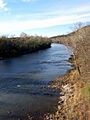
The Meramec River looking north from Route 66 State Park
-
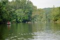
Canoers enjoy a float trip on the Meramec below Leasburg
-
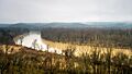
The Meramec River flowing through Castlewood State Park near St. Louis
-
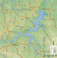
This map shows the extent of the main reservoir that would have been created at Sullivan by the Meramec Basin Project.

