
Pacific, Missouri facts for kids
Quick facts for kids
Pacific, Missouri
|
|
|---|---|
| City of Pacific | |

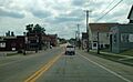
Downtown Pacific in August 2013
|
|

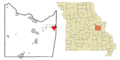
Location of Pacific, Missouri
|
|
| Country | United States of America |
| State | Missouri |
| Counties | Franklin, St. Louis |
| Area | |
| • Total | 6.68 sq mi (17.30 km2) |
| • Land | 6.65 sq mi (17.23 km2) |
| • Water | 0.03 sq mi (0.07 km2) |
| Elevation | 482 ft (147 m) |
| Population
(2020)
|
|
| • Total | 7,414 |
| • Density | 1,114.38/sq mi (430.28/km2) |
| Time zone | UTC-6 (Central (CST)) |
| • Summer (DST) | UTC-5 (CDT) |
| ZIP codes |
63069
|
| Area code(s) | 636 |
| FIPS code | 29-55910 |
| GNIS feature ID | 2396123 |
Pacific (once called Franklin) is a city in the state of Missouri, USA. It's mostly in Franklin County, but a small part reaches into St. Louis County. In 2020, about 7,414 people lived there.
Contents
History of Pacific
How Pacific Began (1820–1864)
The area that is now Pacific started to grow in the early 1800s. The first log cabin was built in 1820. A covered bridge was built over the nearby Meramec River in 1838.
In 1852, a town called Franklin, Missouri, was planned out. The next year, the Pacific Railroad built train tracks through the town. The railroad officially opened on July 19, 1853. A post office opened in 1854 and has been open ever since. The first school in the city was built in 1855.
In 1859, Franklin officially became a city. To honor the important railroad, its name was changed to Pacific.
The Battle of Pacific (1864)
During the American Civil War, on October 1, 1864, a group of soldiers from the Confederate States Army came to Pacific. They were led by General William Cabell. They arrived at sunrise and burned important buildings, including the train station and several bridges.
Union soldiers from nearby Saint Louis quickly came to Pacific. They met the Confederate troops just east of the city. The two groups fought for a few hours. When more Union soldiers arrived, Cabell's troops had to leave Pacific.
Pacific was seen as the last defense against a Confederate attack on Saint Louis. About a dozen soldiers were hurt on each side.
Pacific After the War (1864–1925)
The first newspaper in Pacific, the Franklin County Democrat, was published in 1871. A new train station opened in 1882. It was used until 1961 when train service to Saint Louis stopped. The station was torn down later.
In 1891, a big fire destroyed many buildings in the center of town. The Meramec River also flooded parts of Pacific several times, especially in 1895 and 1915. The old covered bridge south of town was badly damaged by a flood and then removed.
In 1925, the Missouri Botanical Garden bought a large piece of land west of Pacific. They moved some of their special plants, like orchids, there to protect them from pollution in Saint Louis. Later, the plants were moved back to the main garden. The land is now known as Shaw Nature Reserve.
The Route 66 Era (1925–1977)
U.S. Route 66 was a famous highway that started in 1926. In 1933, Route 66 was changed to go through downtown Pacific. As Route 66 became very popular, many travelers stopped in Pacific to eat and stay overnight. Places like the Red Cedar Inn and the Al-Pac Motel opened along Route 66.
Jensen's Point, a scenic overlook, was built in 1939. It offers amazing views of downtown Pacific and the Meramec River. It has been restored and is open to visitors.
In 1959, the U.S. Air Force built a Nike Hercules missile site south of Pacific. This site, called Nike Base SL-60, was one of four missile sites around Saint Louis. It was meant to defend the area during the Cold War. It operated from 1960 to 1968. Later, the city took over the land. Part of it became an elementary school.
In the 1960s, Interstate 44 was built. When it opened in 1965, it bypassed Pacific and Route 66. By 1977, signs for Route 66 in Pacific were removed.
Modern Growth (1977–Present)
The Missouri Eastern Correctional Center, a prison for men, was built east of Pacific in 1979. In 2004, the city of Pacific officially added the prison area to its boundaries.
In 1982, after the Meramec River flooded, a chemical called dioxin spread through a nearby town called Times Beach. This caused health problems, and the town had to be evacuated. Some people from Times Beach moved to Pacific, which made the city's population grow.
The Gustav Grauer Farm, a historic farm north of Pacific, was added to the National Register of Historic Places in 1984.
Geography of Pacific

Pacific is located on the border between Franklin and St. Louis counties. The city is about 30 miles (48 km) northeast of St. Louis.
The city is next to the Pacific Palisades Conservation Area. You can reach the Meramec River through this area. The Union Pacific railroad, the BNSF Railway, and Historic U.S. Route 66 all pass through Pacific.
The city covers about 5.93 square miles (15.36 square kilometers). Most of this is land, with a small amount of water. Pacific is directly west of Eureka and about 5 miles (8 km) east of Gray Summit.


Shopping and Dining Areas
The Old Downtown Commerce Area is mainly along First and St. Louis streets. Many of the old buildings from the late 1800s have been fixed up. New businesses have opened in these historic spots.
The Red Cedar Inn, on the east side of town, was a very old restaurant on Route 66. It was a popular place for people from all over the country to meet. The restaurant closed in 2007.
Population of Pacific
| Historical population | |||
|---|---|---|---|
| Census | Pop. | %± | |
| 1860 | 437 | — | |
| 1870 | 1,208 | 176.4% | |
| 1880 | 1,275 | 5.5% | |
| 1890 | 1,184 | −7.1% | |
| 1900 | 1,213 | 2.4% | |
| 1910 | 1,418 | 16.9% | |
| 1920 | 1,275 | −10.1% | |
| 1930 | 1,456 | 14.2% | |
| 1940 | 1,687 | 15.9% | |
| 1950 | 1,985 | 17.7% | |
| 1960 | 2,795 | 40.8% | |
| 1970 | 3,247 | 16.2% | |
| 1980 | 4,410 | 35.8% | |
| 1990 | 4,350 | −1.4% | |
| 2000 | 5,482 | 26.0% | |
| 2010 | 7,002 | 27.7% | |
| 2020 | 7,414 | 5.9% | |
| U.S. Decennial Census | |||
Population in 2010
In 2010, there were 7,002 people living in Pacific. This number includes people living in the Missouri Eastern Correctional Facility, a large prison in the area. The city had about 1,183 people per square mile (457 people per square kilometer). The average age of people in the city was about 36 years old.
Education in Pacific
Students in Pacific go to schools in the Meramec Valley R-III school system. Many residents also attend St. Louis Community College or East Central College.
Here are some of the schools in the Meramec Valley School District:
- Coleman Elementary School
- Nike Elementary School
- Robertsville Elementary School
- Zitzman Elementary School
- Meramec Valley Early Childhood Center
- Meramec Valley Community School (used to be Pacific Middle School)
- Pacific Intermediate (for 5th and 6th grades)
- Riverbend Middle School (for 7th and 8th grades)
- Pacific High School
St. Bridget of Kildare School is a private school in Pacific for students from pre-kindergarten to 8th grade.
Pacific also has a public library, which is part of the Scenic Regional Library system.
Images for kids
-
Downtown Pacific in August 2013
-
Location of Pacific, Missouri
See also
 In Spanish: Pacific (Misuri) para niños
